
Peach County, Georgia facts for kids
Quick facts for kids
Peach County
|
|
|---|---|

Peach County Courthouse in Fort Valley
|
|

Location within the U.S. state of Georgia
|
|
 Georgia's location within the U.S. |
|
| Country | |
| State | |
| Founded | July 18, 1924 |
| Named for | Peach fruit |
| Seat | Fort Valley |
| Largest city | Fort Valley |
| Area | |
| • Total | 151 sq mi (390 km2) |
| • Land | 150 sq mi (400 km2) |
| • Water | 1.0 sq mi (3 km2) 0.7%% |
| Population
(2020)
|
|
| • Total | 27,981 |
| • Density | 187/sq mi (72/km2) |
| Time zone | UTC−5 (Eastern) |
| • Summer (DST) | UTC−4 (EDT) |
| Congressional district | 2nd |
Peach County is a county located in the central part of Georgia, a state in the U.S.. In 2020, about 27,981 people lived there. Its main town, called the county seat, is Fort Valley.
Peach County was created in 1924, making it Georgia's newest county. It was formed from parts of Houston and Macon counties. The county is named after the peach fruit, because many peaches are grown in this area. Peach County is part of the larger Warner Robins and Macon city areas.
Contents
Geography of Peach County
Peach County is located in the middle of Georgia. It is one of the smallest counties in the state.
According to the U.S. Census Bureau, the county covers a total area of about 151 square miles. Most of this area, about 150 square miles, is land. Only a small part, about 1.0 square mile, is water.
Most of Peach County is in the Lower Ocmulgee River area. This river flows into the Altamaha River. A small part of the county in the north is in the Upper Ocmulgee River area. The very western tip of Peach County is in the Upper Flint River area.
Main Roads in Peach County
Many important roads run through Peach County, helping people travel around.
 Interstate 75
 U.S. Route 41
 U.S. Route 341
 State Route 7
 State Route 7 Connector
 State Route 11
 Georgia State Route 42
 Georgia State Route 49
 State Route 49 Connector
 Georgia State Route 96
 State Route 127
 State Route 247 Connector
 State Route 401 (This is another name for I-75)
 State Route 540 (Fall Line Freeway)
Neighboring Counties
Peach County shares borders with several other counties in Georgia:
- Bibb County - to the north
- Houston County - to the east
- Crawford County - to the northwest
- Taylor County - to the west
- Macon County - to the southwest
Towns and Cities
Peach County is home to several communities:
Cities in Peach County
- Byron (most of this city is in Peach County)
- Fort Valley (This is the county seat, where the county government is located)
- Warner Robins (part of this city is in Peach County)
- Perry (part of this city is in Peach County)
Population Information
| Historical population | |||
|---|---|---|---|
| Census | Pop. | %± | |
| 1930 | 10,268 | — | |
| 1940 | 10,378 | 1.1% | |
| 1950 | 11,705 | 12.8% | |
| 1960 | 13,846 | 18.3% | |
| 1970 | 15,990 | 15.5% | |
| 1980 | 19,151 | 19.8% | |
| 1990 | 21,189 | 10.6% | |
| 2000 | 23,668 | 11.7% | |
| 2010 | 27,695 | 17.0% | |
| 2020 | 27,981 | 1.0% | |
| 2023 (est.) | 28,805 | 4.0% | |
| U.S. Decennial Census 1790-1880 1890-1910 1920-1930 1930-1940 1940-1950 1960-1980 1980-2000 2010 2020 |
|||
As of the 2020 United States census, there were 27,981 people living in Peach County. There were 10,136 households and 6,596 families.
The table below shows the different groups of people living in Peach County over the years. The U.S. Census counts people by their race and ethnicity. Hispanic/Latino is an ethnic group, and people from any race can be Hispanic/Latino.
| Race / Ethnicity | Pop 2000 | Pop 2010 | Pop 2020 | % 2000 | % 2010 | % 2020 |
|---|---|---|---|---|---|---|
| White alone (NH) | 11,654 | 12,499 | 12,119 | 49.24% | 45.13% | 43.31% |
| Black or African American alone (NH) | 10,682 | 12,647 | 12,139 | 45.13% | 45.67% | 43.38% |
| Native American or Alaska Native alone (NH) | 66 | 59 | 63 | 0.28% | 0.21% | 0.23% |
| Asian alone (NH) | 77 | 222 | 194 | 0.33% | 0.80% | 0.69% |
| Pacific Islander alone (NH) | 8 | 8 | 6 | 0.03% | 0.03% | 0.02% |
| Other race alone (NH) | 21 | 26 | 98 | 0.09% | 0.09% | 0.35% |
| Mixed race or Multiracial (NH) | 162 | 344 | 815 | 0.68% | 1.24% | 2.91% |
| Hispanic or Latino (any race) | 998 | 1,890 | 2,547 | 4.22% | 6.82% | 9.10% |
| Total | 23,668 | 27,695 | 27,981 | 100.00% | 100.00% | 100.00% |
Education in Peach County
Schools in Peach County are part of the Peach County School District. The main high school for the county is Peach County High School.
Images for kids
-
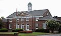
The Peach County Courthouse in Fort Valley.
See also
 In Spanish: Condado de Peach para niños
