Bibb County, Georgia facts for kids
Quick facts for kids
Bibb County
|
|
|---|---|

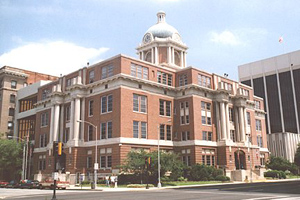
Bibb County courthouse in Macon
|
|

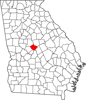
Location within the U.S. state of Georgia
|
|
 Georgia's location within the U.S. |
|
| Country | |
| State | |
| Founded | December 9, 1822 |
| Named for | William Wyatt Bibb |
| Seat | Macon |
| Largest city | Macon |
| Area | |
| • Total | 255 sq mi (660 km2) |
| • Land | 250 sq mi (600 km2) |
| • Water | 5.6 sq mi (15 km2) 2.2%% |
| Population
(2020)
|
|
| • Total | 157,346 |
| • Density | 629/sq mi (243/km2) |
| Time zone | UTC−5 (Eastern) |
| • Summer (DST) | UTC−4 (EDT) |
| Congressional districts | 2nd, 8th |
Bibb County is a county located in the state of Georgia in the United States. In 2020, about 157,346 people lived there. Bibb County is in the central part of Georgia. It is the largest county in the Macon area.
Bibb County has a special combined city-county government. This happened when the county joined with its main city, Macon, in 2014. In 2015, another small town called Payne City also joined this combined government.
Contents
History of Bibb County
This area was home to different groups of indigenous peoples for thousands of years. The Ocmulgee National Monument is a special park and historical site. It has two large mound and village areas built by ancient people. These were created by the Mississippian culture along the Ocmulgee River.
In 1539, an explorer named Hernando de Soto visited a large village called Ichisi. Experts think this village might have been at the Lamar Mounds. For many centuries, the Muscogee tribe lived in a large part of Georgia. They were descendants of the Mississippian culture.
European Settlement and Cotton Plantations
During the time of the colonies, European settlers traded a lot with the Muscogee people. Later, settlers wanted more land to grow cotton. In the 1830s, the Muscogee and other Native American tribes were forced to move. This event was called the "Indian Removal". They had to go to a new area west of the Mississippi River. Many people died during this difficult journey, which is known as the "Trail of Tears".
In the late 1700s, the cotton gin was invented. This machine made it easy to clean cotton. This meant that cotton could be grown in many more places. Bibb County became part of the ""Black Belt"". This name first referred to the rich, dark soil in these farming areas.
European-American farmers developed large cotton farms here. They used enslaved African Americans to do the hard work. Cotton was very valuable and was sold to factories in the northern states and England. By 1860, before the American Civil War, over a million enslaved African Americans lived in Georgia. They made up most of the people in many "Black Belt" counties.
Founding of Bibb County
The state of Georgia officially created Bibb County on December 9, 1822. The city of Macon was made the county seat (the main town for the county) in December 1823. Bibb County was formed from parts of Jones, Monroe, Houston, and Twiggs Counties. The county seat has always been Macon. No other county has ever been made from land that was part of Bibb County.
The county was named after Dr. William Wyatt Bibb. He was a doctor from Georgia who served in the U.S. House of Representatives and the U.S. Senate. Later, he moved to Alabama and became the first governor of that state.
From Civil War to Today
During the American Civil War, about 10% of the white men from Bibb County died fighting for the Confederate States Army. The war led to the freedom of enslaved people across the South. Georgia saw many battles, and some cities were destroyed.
For a long time, the county's economy depended on cotton and other farming. But things like bad weather and the boll weevil (a bug that destroys cotton) caused problems.
Macon, the county seat, continued to be the main city in Bibb County. It was the center of many important events and had many famous places.
On July 31, 2012, people in Macon and Bibb County voted to combine their city and county governments. This idea had failed four times before. The new combined government started on January 1, 2014. A small part of Macon that was in Jones County also became part of Bibb County.
Payne City was another small town in Bibb County. It was completely surrounded by Macon. In the 2012 vote, Payne City voters did not want to join the combined government. But in 2015, the government of Payne City asked to be dissolved. So, it officially became part of Macon-Bibb County.
Geography of Bibb County
Bibb County covers about 255 square miles. About 250 square miles are land, and 5.6 square miles (2.2%) are water. All of Bibb County is located in the Upper Ocmulgee River area. This river flows into the Altamaha River.
Neighboring Counties
- Jones County – to the northeast
- Twiggs County – to the east
- Houston County – to the south
- Peach County – to the south-southwest
- Crawford County – to the southwest
- Monroe County – to the northwest
Protected Natural Areas
Communities in Bibb County
Cities
Unincorporated Communities
These are areas that are not part of an official city.
Population of Bibb County
| Historical population | |||
|---|---|---|---|
| Census | Pop. | %± | |
| 1830 | 7,154 | — | |
| 1840 | 9,802 | 37.0% | |
| 1850 | 12,699 | 29.6% | |
| 1860 | 16,291 | 28.3% | |
| 1870 | 21,255 | 30.5% | |
| 1880 | 27,147 | 27.7% | |
| 1890 | 42,370 | 56.1% | |
| 1900 | 50,473 | 19.1% | |
| 1910 | 56,646 | 12.2% | |
| 1920 | 71,304 | 25.9% | |
| 1930 | 77,042 | 8.0% | |
| 1940 | 83,783 | 8.7% | |
| 1950 | 114,079 | 36.2% | |
| 1960 | 141,249 | 23.8% | |
| 1970 | 143,418 | 1.5% | |
| 1980 | 150,256 | 4.8% | |
| 1990 | 149,967 | −0.2% | |
| 2000 | 153,887 | 2.6% | |
| 2010 | 155,547 | 1.1% | |
| 2020 | 157,346 | 1.2% | |
| 2023 (est.) | 156,512 | 0.6% | |
| U.S. Decennial Census 1790-1880 1890-1910 1920-1930 1930-1940 1940-1950 1960-1980 1980-2000 2010 2020 |
|||
| Race / Ethnicity (NH = Non-Hispanic) | Pop 2000 | Pop 2010 | Pop 2020 | % 2000 | % 2010 | % 2020 |
|---|---|---|---|---|---|---|
| White alone (NH) | 76,262 | 65,494 | 56,787 | 49.56% | 42.11% | 36.09% |
| Black or African American alone (NH) | 72,503 | 80,744 | 85,234 | 47.11% | 51.91% | 54.17% |
| Native American or Alaska Native alone (NH) | 255 | 287 | 281 | 0.17% | 0.18% | 0.18% |
| Asian alone (NH) | 1,632 | 2,492 | 3,209 | 1.06% | 1.60% | 2.04% |
| Pacific Islander alone (NH) | 35 | 74 | 42 | 0.02% | 0.05% | 0.03% |
| Other race alone (NH) | 92 | 215 | 602 | 0.06% | 0.14% | 0.38% |
| Mixed race or Multiracial (NH) | 1,085 | 1,852 | 4,454 | 0.71% | 1.19% | 2.83% |
| Hispanic or Latino (any race) | 2,023 | 4,389 | 6,737 | 1.31% | 2.82% | 4.28% |
| Total | 153,887 | 155,547 | 157,346 | 100.00% | 100.00% | 100.00% |
As of the 2020 United States census, there were 157,346 people living in Bibb County. There were 56,726 households and 33,573 families.
Fun Things to Do
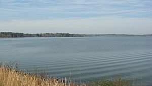
Lake Tobesofkee is about 10 miles west of Macon. It has three parks: Claystone, Sandy Beach, and Arrowhead Parks. Each park has a beach and playgrounds for kids. Sandy Beach also has tennis courts with lights, a water park with fun rides, and a softball field.
Getting Around Bibb County
Major Roads
 Interstate 16
 Interstate 75
 Interstate 475
 U.S. Route 23
 U.S. Route 41
- U.S. Route 41 Business (Macon)
 U.S. Route 80
 U.S. Route 129
- U.S. Route 129 Alternate (Macon)
 State Route 11
 State Route 19
 State Route 22
 State Route 49
 State Route 74
 State Route 87
 State Route 87 Connector
 State Route 247
 State Route 401 (this is the hidden name for I-75)
 State Route 404 (this is the hidden name for I-16)
 State Route 408 (this is the hidden name for I-475)
 State Route 540 (Fall Line Freeway)
Walking and Biking Paths
- Heritage Trail
- Ocmulgee Heritage Trail
See also
 In Spanish: Condado de Bibb (Georgia) para niños
 | John T. Biggers |
 | Thomas Blackshear |
 | Mark Bradford |
 | Beverly Buchanan |


