Ideal, Georgia facts for kids
Quick facts for kids
Ideal, Georgia
|
|
|---|---|

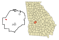
Location in Macon County and the state of Georgia
|
|
| Country | United States |
| State | Georgia |
| County | Macon |
| Area | |
| • Total | 1.15 sq mi (2.99 km2) |
| • Land | 1.14 sq mi (2.96 km2) |
| • Water | 0.01 sq mi (0.03 km2) |
| Elevation | 482 ft (147 m) |
| Population
(2020)
|
|
| • Total | 407 |
| • Density | 355.77/sq mi (137.34/km2) |
| Time zone | UTC-5 (Eastern (EST)) |
| • Summer (DST) | UTC-4 (EDT) |
| ZIP code |
31041
|
| Area code(s) | 478 |
| FIPS code | 13-40812 |
| GNIS feature ID | 0356328 |
Ideal is a small city located in Macon County, Georgia, in the United States. In 2020, about 407 people lived there. This was a bit less than the 499 people who lived there in 2010.
Contents
History of Ideal
Ideal has an interesting story behind its name. The town was first called "Joetown."
How Ideal Got Its Name
One day, two important railroad executives visited the town. One of them said it was an "ideal" spot for a train station. The other executive quickly said, "I've just named it!" That's how Joetown became Ideal.
When Ideal Became a Town
The Georgia General Assembly, which is Georgia's state legislature, officially made Ideal a town in 1906. This meant it had its own local government.
Geography of Ideal
Ideal is found in the western part of Macon County. Its exact location is 32.372918 degrees North and 84.188822 degrees West.
Roads and Nearby Towns
Georgia State Route 90 goes right through the middle of Ideal. If you drive southeast on this road for about 10 miles (16 km), you'll reach Oglethorpe. Oglethorpe is the main town, or county seat, for Macon County. If you drive northwest for about 8 miles (13 km), you'll get to Rupert.
Land and Water Features
The city of Ideal covers about 1.16 square miles (2.99 square kilometers). Most of this area is land. Only a tiny part, about 0.01 square miles (0.03 square kilometers), is water. Ideal is located where two creeks, Whitewater and Cedar creeks, meet. These creeks are fed by springs and flow into the Flint River.
People of Ideal (Demographics)
The population of Ideal has changed over the years. Here's a look at how many people have lived there during different census counts:
| Historical population | |||
|---|---|---|---|
| Census | Pop. | %± | |
| 1910 | 186 | — | |
| 1920 | 304 | 63.4% | |
| 1930 | 285 | −6.2% | |
| 1940 | 238 | −16.5% | |
| 1950 | 318 | 33.6% | |
| 1960 | 432 | 35.8% | |
| 1970 | 543 | 25.7% | |
| 1980 | 619 | 14.0% | |
| 1990 | 554 | −10.5% | |
| 2000 | 518 | −6.5% | |
| 2010 | 499 | −3.7% | |
| 2020 | 407 | −18.4% | |
| U.S. Decennial Census 1850-1870 1880 1890-1910 1920-1930 1930-1940 1940-1950 1960-19801990 |
|||
Population Breakdown in 2020
In 2020, there were 407 people living in Ideal. These people lived in 124 households, and 64 of these were families.
Here's a closer look at the different groups of people living in Ideal in 2020:
| Group | Number of People | Percentage |
|---|---|---|
| White (not Hispanic) | 113 | 27.76% |
| Black or African American (not Hispanic) | 270 | 66.34% |
| Asian | 1 | 0.25% |
| Other/Mixed (two or more races) | 21 | 5.16% |
| Hispanic or Latino | 2 | 0.49% |
See also
 In Spanish: Ideal (Georgia) para niños
 | George Robert Carruthers |
 | Patricia Bath |
 | Jan Ernst Matzeliger |
 | Alexander Miles |

