Flint River facts for kids
Quick facts for kids Flint River |
|
|---|---|

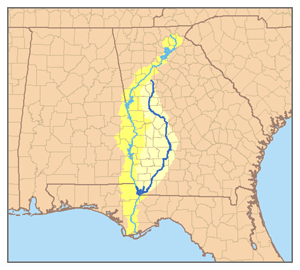
Map of the Apalachicola River system with the Flint River in dark blue and its watershed highlighted.
|

The Flint River is a long river in the state of Georgia, USA. It stretches about 344 miles (554 km) from north to south. This river helps drain a large area of western Georgia, about 8,460 square miles (21,900 km²).
The Flint River starts near Atlanta in the Piedmont region. It then flows south through wetlands in the southwestern part of Georgia. It is part of a bigger river system called the ACF basin. This basin also includes the Apalachicola and Chattahoochee rivers.
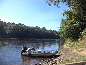
The upper part of the Flint River is very beautiful. It flows freely for over 200 miles (320 km) without any dams. Long ago, people also called it the Thronateeska River.
Contents
About the Flint River
The Flint River begins in East Point, a city south of Atlanta. It starts as water seeping from the ground. You can find its exact start near Plant Street, Willingham Drive, Elm Street, and Vesta Avenue. The river even flows under the runways of the Hartsfield-Jackson Atlanta International Airport.
The River's Journey
As the river flows south, it goes through the countryside of western Georgia. Smaller streams like Line Creek and Whitewater Creek join it. The river passes by Sprewell Bluff State Park, which is about 10 miles (16 km) west of Thomaston.
Further south, the river gets close to Andersonville. This town is famous for the Andersonville prison from the Civil War.
Cities and Lakes Along the River
In southwestern Georgia, the Flint River flows right through downtown Albany. Albany is the biggest city located on the river. Near Bainbridge, the Flint River meets Lake Seminole. This lake is formed where the Flint and Chattahoochee rivers come together. From Lake Seminole, the Apalachicola River continues south into Florida and then to the Gulf of Mexico.
Other streams also feed the Flint River. Kinchafoonee Creek joins it just north of Albany. Ichawaynochaway Creek flows into it in southwestern Mitchell County.
Besides Lake Seminole, another lake called Lake Blackshear is on the Flint River. It is about 15 miles (24 km) upstream from Albany.
A River Without Dams
The Flint River is special because it flows for over 200 miles (320 km) without any dams. Only about 40 rivers in the entire country are like this. This makes the Flint River very important for nature.
In the 1970s, there was a plan to build a dam at Sprewell Bluff. But Jimmy Carter, who was the Governor of Georgia at the time, and others stopped the plan. Carter's hometown of Plains is also close to the Flint River.
Nature and History of the River
The Flint River changes its look as it flows south through Georgia. Scientists divide it into three main parts.
River Sections
- Upper Part: In the red hills of the Piedmont region, the river flows through a deep channel. This channel is cut into hard, crystal-like rocks.
- Middle Part: South of a natural boundary called the fall line near Culloden, the river changes. It becomes a wide, swampy area with lots of trees.
- Lower Part: South of Lake Blackshear, the river changes again. It flows through a channel made of limestone rock. This part of the river is above the Upper Floridan Aquifer, which is a huge underground water source.
Major Floods
The Flint River has often experienced floods throughout history.
- 1994 Flood: In 1994, a big flood happened because of Tropical Storm Alberto. The river rose to 43 feet (13 meters) in Albany. This caused more than 23,000 people to leave their homes. It was one of the worst natural disasters in Georgia's history. The water was so high that Interstate 75 was closed in Macon. Albany State University was also badly flooded. The river became several miles wide in some places.
- Montezuma Flood: The town of Montezuma, Georgia was completely covered by water. The river went over a 29-foot (9-meter) wall that was supposed to protect the town. Cleanup in Albany took many months.
- Other Floods: Another serious flood happened in Albany in 1998, but it was not as bad as the 1994 one. Bainbridge also flooded in 1998. Other big floods happened in 1841 and 1925.
Environmental Concerns
In January 2002, a winter storm hit Atlanta. The airport's drainage system overflowed, and deicing fluid leaked into the river. This fluid got into the drinking water for some people. Luckily, no one got seriously sick. The airport later changed its drainage system to prevent this from happening again.
In May 2009, the Lower Flint River was named one of the "10 Waters to Watch" by the National Fish Habitat Action Plan. This was because of efforts to restore its natural habitats. However, in October 2009, AmericanRivers.org said the Flint was one of the most endangered rivers in the country. This was mainly due to new plans to build a dam on it.
Special Plants
The Flint River is home to a special plant called the Hymenocallis coronaria, also known as the Shoals spider-lily. This flower is rare and grows in only a few rivers in the southeastern United States. Four groups of these plants have been found and studied in the Flint River.
See also
 In Spanish: Río Flint para niños
 | Ernest Everett Just |
 | Mary Jackson |
 | Emmett Chappelle |
 | Marie Maynard Daly |


