Floridan aquifer facts for kids
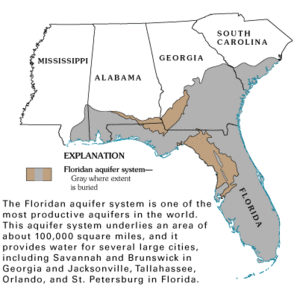
The Floridan aquifer system is a huge underground water source. It's made of layers of carbonate rock (like limestone) that hold water. This system covers about 100,000 square miles in the southeastern United States. It's found under all of Florida and parts of Alabama, Georgia, Mississippi, and South Carolina.
The Floridan aquifer system is one of the biggest and most important underground water sources in the world. It provides drinking water for almost 10 million people! In 2000, it was the 5th most used aquifer in the U.S. About 3,640 million gallons of water were taken from it every day. Most of this water (49%) was used for watering crops. Public water supply used 33%, industries used 14%, and homes used 4%. This aquifer is the main source of drinking water for many cities in Florida and Georgia.
Contents
How the Floridan Aquifer System Was Discovered
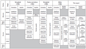
In 1936, a geologist named Victor Timothy Stringfield first found this huge water system in Florida. He called the rock layers the "principal artesian formations." Later, in 1944, M.A. Warren found that this system extended into southern Georgia. He used the term "principal artesian aquifer" for these rocks.
In 1955, another scientist, Garald G. Parker, noticed that the rock layers in southeast Florida were very similar. He realized they were all part of one big water unit and named it the "Floridan aquifer." As scientists learned more, they found different zones within this system. So, the name changed to the "Floridan aquifer system." It now includes the Upper and Lower Floridan aquifers.
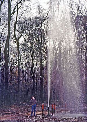
People started taking water from the Floridan aquifer system in 1887. The city of Savannah, Georgia, began using it for drinking water. Back then, the water pressure was so high that water shot out of wells without needing pumps! By 1898, hundreds of wells were in use in South Georgia. By 1943, there were about 3,500 wells in Georgia's coastal counties.
Water use grew steadily from 1950 to 1990. In the 1990s, new rules helped slow down the increase in water use. However, during a big drought from 1999 to 2001, water use went up again. This was mainly because more water was needed for farms.
Where the Floridan Aquifer System Is Found
The Floridan aquifer system covers about 100,000 square miles in the southeastern U.S. It's under all of Florida and parts of southern Alabama, southeastern Georgia, and southern South Carolina. The top part of the aquifer, called the Upper Floridan aquifer, has fresh water in most places. But it can be salty in areas south of Lake Okeechobee.
In central and southern Georgia, the limestone rocks of the aquifer are visible at the surface. This means they "crop out." As you go south, the aquifer usually dips underground. It gets covered by layers of sand and clay. In areas where the aquifer is close to the surface, sinkholes are more likely to form. This is because the limestone can dissolve easily. Some of the underground passages are so big that scuba divers can swim through them!
How Water Moves Through the Aquifer
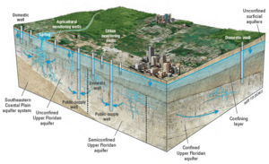
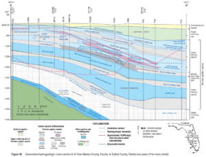
The rocks that make up the Floridan aquifer system formed a very long time ago. They are covered by layers of clay and sand. In some areas, like west-central Florida, the limestone is at the surface. Here, the aquifer is "unconfined," meaning water can easily soak into it. In other places, thick layers of clay cover the aquifer. Here, the aquifer is "confined," and the water is under pressure.
Water enters the aquifer (this is called "recharge") and flows through it. It then leaves the aquifer in places like springs (this is called "discharge"). How easily water moves depends on how much the aquifer is covered. Where the aquifer is at or near the surface, water dissolves the limestone. This creates many springs and sinkholes. Springs form when the water pressure is strong enough to push groundwater out onto the land. Florida has over 700 mapped springs! Wakulla Springs is one of the largest, with millions of gallons of water flowing out each day.
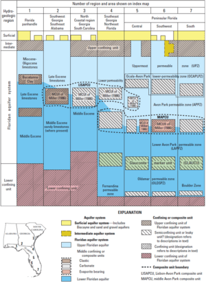
The Floridan aquifer system has two main parts: the Upper Floridan aquifer and the Lower Floridan aquifer. These two parts are sometimes separated by layers of clay or other rocks. If these layers are permeable (meaning water can pass through them), the Upper and Lower parts act like one unit. If the layers are less permeable, they are more separate.
Upper Floridan Aquifer
The Upper Floridan aquifer is the main source of water taken from the Floridan aquifer system. This is because it's close to the surface and holds a lot of water. The water in the Upper Floridan is mostly fresh. However, it can be salty in coastal areas due to saltwater intrusion (when ocean water seeps in). In central and southern Florida, the Upper Floridan aquifer is very thick. It can be divided into three different zones.
Lower Floridan Aquifer
The Lower Floridan aquifer usually lets less water pass through it than the Upper Floridan. The water here can also be more salty or have more minerals. However, in central Florida and parts of Georgia and Alabama, the Lower Floridan aquifer has fresh water.
A new area called the Oldsmar permeable zone has been mapped in Florida. This zone seems to have very high permeability, meaning water flows through it easily. It also contains fresh water in the central part of Florida. This new discovery is important because it could be a new source of water. It might also affect how groundwater moves deep within the aquifer system.
How Water Flows Through the Rocks
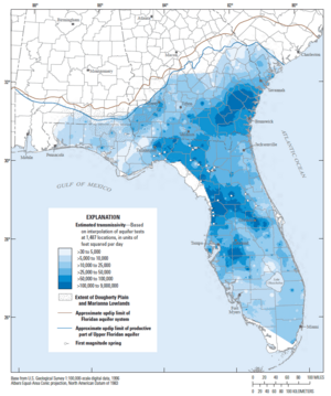
The rocks in the Floridan aquifer system are like sponges, but they vary a lot. Some parts let water flow through very easily, while others do not. This ability to let water pass through is called "transmissivity." It can change a lot from one place to another.
Where the aquifer is not covered or only thinly covered, water seeps in and dissolves the rock. This creates large pathways, so water flows very easily. Where the aquifer is covered by thick layers of clay, less dissolving happens. So, water flows less easily there. Scientists have mapped these differences. They found that water flows much faster where the aquifer is unconfined or thinly covered.
Sinkholes: Holes in the Ground
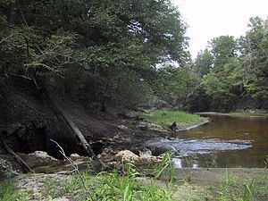
Sinkholes are common where the ground below is made of limestone or other rocks that can dissolve in water. As groundwater moves, it slowly dissolves these rocks, creating empty spaces and caverns underground. If the land above these spaces doesn't have enough support, it can suddenly collapse. These collapses can be small or very large, sometimes swallowing houses or roads.
Sinkholes form in different ways:
- Dissolution sinkholes happen when water directly dissolves the rock.
- Cover-subsidence sinkholes form slowly when loose soil above the rock gradually sinks.
- Cover-collapse sinkholes happen suddenly when the ground above a dissolved space collapses.
Taking out a lot of groundwater quickly, like for watering crops, can make sinkholes form faster. For example, Lake Jackson sometimes drains into a sinkhole at its bottom when the aquifer's water levels drop.
Springs: Water Flowing Out
There are 824 springs connected to the Floridan aquifer system. Most of them (751) are in Florida, 17 in Alabama, and 56 in Georgia. Springs are ranked by how much water flows out of them.
| Magnitude | Flow (cubic feet per second) |
|---|---|
| 1st magnitude | More than 100 cubic feet per second |
| 2nd magnitude | 10 to 100 cubic feet per second |
| 3rd magnitude | 1 to 10 cubic feet per second |
| 4th magnitude | 100 US gallons per minute to 1 cubic foot per second |
| 5th magnitude | 10 to 100 gallons per minute |
| 6th magnitude | 1 to 10 gallons per minute |
| 7th magnitude | 2 pints per minute to 1 gallon per minute |
| 8th magnitude | Less than 1 pint per minute |
| 0 magnitude | No flow (places where water used to flow) |
Florida has 33 "first magnitude" springs, which are the largest. Some famous ones include:
- Spring Creek (Wakulla County)
- Three Sisters Springs (Citrus County)
- Silver Springs (Marion County)
- Rainbow Springs (Marion County)
- Wakulla Spring (Wakulla County)
- Wacissa Spring Group (Jefferson County)
- Ichetucknee Springs (Columbia County)
- Weeki Wachee Springs (Hernando County)
- Juniper Springs (Marion County)
Georgia has only one first magnitude spring, Radium Spring, which sometimes stops flowing during dry times. Alabama has three third magnitude springs, which are smaller. Many springs are also found offshore in the Gulf of Mexico and Atlantic Ocean.
See also
- Biscayne Aquifer
- Kissingen Springs
- Woodville Karst Plain
- Gulf Trough
- Hydrogeology
- Cave diving
- Water wars in Florida
- Fountain of Youth
 | Claudette Colvin |
 | Myrlie Evers-Williams |
 | Alberta Odell Jones |


