
Lake Seminole facts for kids
Quick facts for kids Lake Seminole |
|
|---|---|

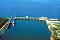
Jim Woodruff Lock and Dam. This earthen dam is over one mile (1.6 km) long but this photograph shows only the concrete and steel lock and water control structure of the dam. Florida is on the left, Georgia the right.
|
|

Lake Seminole
Location in Florida

Lake Seminole
Location in the United States
|
|
| Location | Georgia–Florida border, United States |
| Coordinates | 30°42′29″N 84°51′47″W / 30.708°N 84.863°W |
| Primary inflows | Chattahoochee, Flint River |
| Primary outflows | Apalachicola River |
| Catchment area | 17,200 sq mi (44,548 km2) |
| Basin countries | United States |
| Max. length | 35 mi (56 km) |
| Max. width | 2 mi (3.2 km) |
| Surface area | 37,500 acres (152 km2) |
| Average depth | 10 ft (3.0 m) |
| Max. depth | 30 ft (9.1 m) |
| Shore length1 | 376 mi (605 km) |
| Surface elevation | 77.5 ft (23.6 m) |
| 1 Shore length is not a well-defined measure. | |
Lake Seminole is a large reservoir (an artificial lake) located in the southwest part of Georgia. It sits right on the border with Florida. The U.S. Army Corps of Engineers takes care of the lake.
Two important rivers, the Chattahoochee and the Flint River, meet in Lake Seminole. From there, the water flows out through the Jim Woodruff Lock and Dam and becomes the Apalachicola River.
Lake Seminole covers about 37,500 acres of water. Its shoreline stretches for 376 miles, which is a very long distance! The lake is a popular spot for fishing, especially for largemouth bass. You can also find other fish like crappie, catfish, and striped bass. Besides fish, American alligators, snakes, and many types of waterfowl (like ducks and geese) live here. The lake is well-known for goose hunting.
Contents
Building Lake Seminole
The idea for Lake Seminole and the Jim Woodruff Dam started in 1946. The United States Congress approved the project, and construction began the next year. The dam was finished in 1952, and the lake officially opened in 1957.
The project was first expected to cost around $29 million. However, by the time it was completed, it cost $46.5 million. The lake was named after the Seminole Native American people.
About the Jim Woodruff Dam
The Jim Woodruff Dam is a very important part of Lake Seminole. It is located about 1,000 feet south of where the Chattahoochee and Flint Rivers used to meet naturally. This dam helps produce electricity and allows boats to travel on the river.
The dam is named after James W. Woodruff, Sr.. He was a businessman from Georgia who worked hard to develop the Apalachicola-Chattahoochee-Flint River system.
Dam Location
The Jim Woodruff Dam crosses the state line between Georgia and Florida. The eastern part of the dam is in Georgia. However, most of the dam, including the locks, gates, and power plant, is actually in Florida. It's just 100 feet south of Georgia's southeast corner.
Boating and Travel
The Jim Woodruff Dam has a single lock for boats. This lock is 450 feet long and 82 feet wide. It allows boats to travel from the Apalachicola River and the Gulf of Mexico into Lake Seminole and the rivers upstream.
Lake Seminole stretches far up the rivers. It goes about 30 miles along the Chattahoochee River. It also extends about 35 miles up the Flint River.
Fun at the Lake Parks
The United States Army Corps of Engineers manages 10 parks along the shores of Lake Seminole. In total, there are 35 parks available for people to enjoy outdoor activities. Five of these parks are campgrounds where you can stay overnight.
- Seminole State Park in Georgia covers 604 acres of land along the lake.
- Three Rivers State Park in Florida covers 686 acres of wetlands north of Sneads, Florida.
Historical Sites
Lake Seminole is also home to some interesting historical sites.
San Carlos de los Chacatos Mission
The West Bank Overlook, at the western end of the dam, is where the old Spanish mission called San Carlos de los Chacatos once stood. This mission was built in 1674 after a revolt by the Chacato people.
The mission was used by explorers like Marcos Delgado and Don Laureano de Torres y Ayala. It was attacked by Alibamu warriors in 1696. Later, during Queen Anne's War, British forces led by Colonel James Moore attacked it, and the mission was abandoned.
In 1813, during the Creek War, Uchee refugees resettled the site. But it was abandoned again in 1818 during the First Seminole War. The site was not found again until 1948 during archaeological work for the construction of Lake Seminole.
Fort Scott History
Fort Scott was built in 1816. It was located on the west bank of the Flint River, just before it flowed into the Apalachicola River. The fort's purpose was to protect the southern border of the United States at that time. This area was often subject to invaders coming from or through Spanish territory.
The fort was abandoned after Florida became a U.S. territory in 1821. There was no longer a border to defend there. Today, the site of Fort Scott is under the waters of Lake Seminole.
Images for kids
-
Jim Woodruff Lock and Dam. This earthen dam is over one mile (1.6 km) long but this photograph shows only the concrete and steel lock and water control structure of the dam. Florida is on the left, Georgia the right.
