Oglethorpe, Georgia facts for kids
Quick facts for kids
Oglethorpe, Georgia
|
|
|---|---|

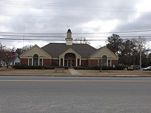
Oglethorpe municipal building in Oglethorpe
|
|

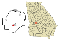
Location in Macon County and the state of Georgia
|
|
| Country | United States |
| State | Georgia |
| County | Macon |
| Area | |
| • Total | 2.05 sq mi (5.32 km2) |
| • Land | 2.01 sq mi (5.20 km2) |
| • Water | 0.05 sq mi (0.12 km2) |
| Elevation | 341 ft (104 m) |
| Population
(2020)
|
|
| • Total | 995 |
| • Density | 496.01/sq mi (191.49/km2) |
| Time zone | UTC-5 (EST) |
| • Summer (DST) | UTC-4 (EDT) |
| ZIP code |
31068
|
| Area code(s) | 478 |
| FIPS code | 13-57736 |
| GNIS feature ID | 0332561 |
Oglethorpe is a city located in Macon County, Georgia, in the United States. In 2020, about 995 people lived there. It is the main city, or county seat, of Macon County. The city was named after James Oglethorpe, who founded the state of Georgia.
Contents
History of Oglethorpe
Oglethorpe was started in 1838. It was in an area of Georgia known as the Black Belt. Here, many enslaved people worked on large farms, mostly growing cotton. Cotton was a very important crop that was sold for money.
The town became an official town in 1849 and a city in 1852. In 1857, Oglethorpe became the county seat for Macon County, taking over from Lanier.
Challenges in the 1860s
Oglethorpe was once one of the biggest cities in southwestern Georgia. However, in the early 1860s, serious outbreaks of diseases like malaria and smallpox caused many deaths. Because of this, the people who were still living in Oglethorpe moved south to Americus to escape the sickness.
Geography of Oglethorpe
Oglethorpe is in the southern part of Macon County. It is located on high ground to the west of the Flint River. This river forms the border between Oglethorpe and the nearby city of Montezuma.
Main Roads and Connections
Several important roads pass through Oglethorpe. Georgia State Route 49 goes through the center of town. It connects Oglethorpe to Montezuma in the east and Marshallville to the northeast. To the southwest, it leads to Americus.
Georgia State Route 90 also runs through Oglethorpe. It connects the city to Rupert to the northwest and Vienna to the southeast. Georgia State Route 128 also heads north from Oglethorpe, leading to Reynolds.
Another important road, Georgia State Route 26, passes through the south side of Oglethorpe. It goes east through Montezuma to Hawkinsville and west to Ellaville.
Land and Water Area
The U.S. Census Bureau says that Oglethorpe covers about 2.1 square miles (5.4 square kilometers). Most of this area is land, with a small part, about 0.05 square miles (0.13 square kilometers), being water.
Population and Demographics
| Historical population | |||
|---|---|---|---|
| Census | Pop. | %± | |
| 1850 | 113 | — | |
| 1860 | 454 | 301.8% | |
| 1870 | 400 | −11.9% | |
| 1880 | 442 | 10.5% | |
| 1890 | 486 | 10.0% | |
| 1900 | 545 | 12.1% | |
| 1910 | 924 | 69.5% | |
| 1920 | 871 | −5.7% | |
| 1930 | 953 | 9.4% | |
| 1940 | 1,048 | 10.0% | |
| 1950 | 1,204 | 14.9% | |
| 1960 | 1,169 | −2.9% | |
| 1970 | 1,286 | 10.0% | |
| 1980 | 1,305 | 1.5% | |
| 1990 | 1,302 | −0.2% | |
| 2000 | 1,200 | −7.8% | |
| 2010 | 1,328 | 10.7% | |
| 2020 | 995 | −25.1% | |
| U.S. Decennial Census 1850-1870 1870-1880 1890-1910 1920-1930 1940 1950 1960 1970 1980 1990 2000 2010 |
|||
Oglethorpe was first counted in the 1850 U.S. Census. The population has changed over the years. In 2020, there were 995 people living in the city. There were 561 households and 351 families.
Education in Oglethorpe
Macon County School District
The Macon County School District serves students from pre-school all the way to twelfth grade. The district has one elementary school, one middle school, and one high school. There are about 129 full-time teachers and over 2,200 students in the district.
- Macon County Elementary School
- Macon County Middle School
- Macon County High School
See also
 In Spanish: Oglethorpe para niños
 | John T. Biggers |
 | Thomas Blackshear |
 | Mark Bradford |
 | Beverly Buchanan |

