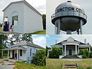
Junction City, Georgia facts for kids
Quick facts for kids
Junction City, Georgia
|
|
|---|---|

Junction City (in 2012)
|
|

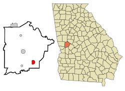
Location in Talbot County and the state of Georgia
|
|
| Country | United States |
| State | Georgia |
| County | Talbot |
| Government | |
| • Type | Mayor-council government |
| Area | |
| • Total | 2.48 sq mi (6.42 km2) |
| • Land | 2.35 sq mi (6.09 km2) |
| • Water | 0.13 sq mi (0.33 km2) |
| Elevation | 689 ft (210 m) |
| Population
(2020)
|
|
| • Total | 138 |
| • Density | 58.70/sq mi (22.67/km2) |
| Time zone | UTC-5 (Eastern (EST)) |
| • Summer (DST) | UTC-4 (EDT) |
| ZIP code |
31812
|
| Area code(s) | 706 |
| FIPS code | 13-42800 |
| GNIS feature ID | 316309 |
Junction City is a small town in Talbot County, Georgia, United States. It's a quiet place with a population of 138 people, according to the 2020 census. This town got its name because it's located where different railway lines used to meet.
Contents
History of Junction City
Junction City was planned out and built where several railway lines came together. This is why it's called "Junction City." The state's government, called the Georgia General Assembly, officially made Junction City a town in 1906. This means it became a recognized place with its own local government.
Geography and Location
Junction City is located in the state of Georgia. Its exact spot on a map is 32.603083 degrees North and 84.458190 degrees West.
Roads and Travel
The town is on the Fall Line Freeway. This freeway includes Georgia State Routes 96 and 540. It goes through the town from west to east. If you go east, it's about 15 miles (24 km) to Butler. If you go west, it's about 39 miles (63 km) to Columbus.
Another road, Georgia State Route 90, also runs through Junction City. This road goes northwest about 8 miles (13 km) to Talbotton. Talbotton is the main town in Talbot County. Route 90 also goes southeast about 8 miles (13 km) to Mauk.
Area and Water
The United States Census Bureau says that Junction City covers a total area of about 2.5 square miles (6.4 square kilometers). Most of this area is land. Only a small part, about 0.1 square miles (0.3 square kilometers), is water.
Population and Demographics
Demographics is the study of a population. It looks at things like how many people live in a place and what groups they belong to.
Population Changes Over Time
The population of Junction City has changed quite a bit over the years. When it first appeared in the U.S. census in 1910, 225 people lived there. The population grew for a while, reaching its highest point in 1930 with 341 people. Since then, the number of people living in Junction City has generally decreased.
| Historical population | |||
|---|---|---|---|
| Census | Pop. | %± | |
| 1910 | 225 | — | |
| 1920 | 323 | 43.6% | |
| 1930 | 341 | 5.6% | |
| 1940 | 326 | −4.4% | |
| 1950 | 259 | −20.6% | |
| 1960 | 226 | −12.7% | |
| 1970 | 269 | 19.0% | |
| 1980 | 254 | −5.6% | |
| 1990 | 182 | −28.3% | |
| 2000 | 179 | −1.6% | |
| 2010 | 177 | −1.1% | |
| 2020 | 138 | −22.0% | |
| U.S. Decennial Census 1850-1870 1880 1890-1910 1920-1930 1930-1940 1940-1950 1960-1980 1980-2000 |
|||
In the 2020 census, the population was 138 people. This shows that Junction City is a very small town.
See also
 In Spanish: Junction City (Georgia) para niños
 | Toni Morrison |
 | Barack Obama |
 | Martin Luther King Jr. |
 | Ralph Bunche |

