Hamilton, Georgia facts for kids
Quick facts for kids
Hamilton, Georgia
|
|
|---|---|

Hamilton, Georgia
|
|
| Motto(s):
"The heart of Harris County"
|
|

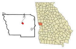
Location in Harris County and the state of Georgia
|
|
| Country | United States |
| State | Georgia |
| County | Harris |
| Named for | Paul Hamilton |
| Area | |
| • Total | 3.41 sq mi (8.84 km2) |
| • Land | 3.41 sq mi (8.84 km2) |
| • Water | 0.00 sq mi (0.00 km2) |
| Elevation | 771 ft (235 m) |
| Population
(2020)
|
|
| • Total | 1,680 |
| • Density | 492.09/sq mi (190.02/km2) |
| Time zone | UTC-5 (Eastern (EST)) |
| • Summer (DST) | UTC-4 (EDT) |
| ZIP code |
31811
|
| Area code(s) | 706 |
| FIPS code | 13-36220 |
| GNIS feature ID | 0315055 |
Hamilton is a city in the state of Georgia, United States. It is the main town, or county seat, of Harris County. Hamilton is also part of the larger Columbus, Georgia metropolitan area. In 2020, about 1,680 people lived in Hamilton. This was a big jump from just 307 people in 2000!
Contents
History of Hamilton
Hamilton was started in 1827. It became the county seat for the new Harris County that same year. It was officially made a town in 1828. Later, in 1903, it became a city.
The city got its name from Paul Hamilton. He was an important person in the past. He served as the United States Secretary of the Navy. He was also a Governor of South Carolina.
Geography of Hamilton
Hamilton is located at coordinates 32.764669 degrees North and -84.873103 degrees West. U.S. Route 27 is a major road that goes through the city. It runs from north to south. This road can take you about 25 miles (40 km) southwest to Columbus. It also goes about 8 miles (13 km) north to Pine Mountain. Another road, Georgia State Route 116, crosses U.S. Route 27 in Hamilton.
The city is found at the southern base of the Pine Mountain Range. This is the southernmost mountain range of the Appalachian Mountains in the U.S. The United States Census Bureau says that Hamilton covers about 2.1 square miles (5.4 square kilometers) of land. There is no water area within the city limits.
Population and People
| Historical population | |||
|---|---|---|---|
| Census | Pop. | %± | |
| 1870 | 359 | — | |
| 1880 | 493 | 37.3% | |
| 1900 | 418 | — | |
| 1910 | 403 | −3.6% | |
| 1920 | 437 | 8.4% | |
| 1930 | 438 | 0.2% | |
| 1940 | 473 | 8.0% | |
| 1950 | 449 | −5.1% | |
| 1960 | 396 | −11.8% | |
| 1970 | 357 | −9.8% | |
| 1980 | 495 | 38.7% | |
| 1990 | 454 | −8.3% | |
| 2000 | 307 | −32.4% | |
| 2010 | 1,016 | 230.9% | |
| 2020 | 1,680 | 65.4% | |
| U.S. Decennial Census | |||
In 2010, a census (a count of the population) showed that 1,016 people lived in Hamilton. There were 339 households and 179 families. By the year 2020, the population grew to 1,680 people.
Education in Hamilton
Hamilton is home to three of the seven schools in Harris County. These schools help students learn and grow.
- Park Elementary School
- Harris County Carver Middle School
- Harris County High School
City Roads and Transport
The main roads in Hamilton are U.S. Route 27 and Georgia State Route 116. These highways help people travel in and out of the city.
See also
 In Spanish: Hamilton (Georgia) para niños
 | Sharif Bey |
 | Hale Woodruff |
 | Richmond Barthé |
 | Purvis Young |

