
Shiloh, Georgia facts for kids
Quick facts for kids
Shiloh, Georgia
|
|
|---|---|
|
City
|
|

Shiloh, Lagrange , Georgia
|
|

Location in Harris County and the state of Georgia
|
|
| Country | United States |
| State | Georgia |
| Counties | Harris |
| Area | |
| • Total | 2.22 sq mi (5.74 km2) |
| • Land | 2.19 sq mi (5.67 km2) |
| • Water | 0.03 sq mi (0.07 km2) |
| Elevation | 892 ft (272 m) |
| Population
(2020)
|
|
| • Total | 402 |
| • Density | 183.65/sq mi (70.90/km2) |
| ZIP Code |
31826
|
| Area code(s) | 706 |
| FIPS code | 13-70428 |
| GNIS feature ID | 333034 |
Shiloh is a small city in Harris County, Georgia, United States. It is located in the northeastern part of the county. Shiloh is also part of the larger Columbus, Georgia–Alabama metropolitan area. In 2020, about 402 people lived there.
History of Shiloh
A post office opened in Shiloh in 1874. The community got its name from the local Shiloh Baptist Church. The church itself was named after Shiloh, a place mentioned in the Hebrew Bible. The state of Georgia officially recognized Shiloh as a city in 1961.
Geography of Shiloh
Shiloh is in the northeast corner of Harris County. It is located along Alternate U.S. Route 27. This road goes southwest about 33 miles (53 km) to Columbus. It also goes north about 6 miles (10 km) to Warm Springs.
Georgia State Route 85 is east of the city. It leads northeast about 6 miles (10 km) to Manchester. Georgia State Route 116 crosses Alternate U.S. Route 27 in Shiloh. This route goes east about 10 miles (16 km) to Woodland. It also goes west about 13 miles (21 km) to Hamilton. The big city of Atlanta is about 78 miles (126 km) northeast by road. Shiloh is in the Piedmont region of Georgia.
The city covers a total area of about 2.22 square miles (5.74 km²). A small part of this area, about 0.03 square miles (0.07 km²), is water.
Population of Shiloh
| Historical population | |||
|---|---|---|---|
| Census | Pop. | %± | |
| 1970 | 298 | — | |
| 1980 | 392 | 31.5% | |
| 1990 | 329 | −16.1% | |
| 2000 | 423 | 28.6% | |
| 2010 | 445 | 5.2% | |
| 2020 | 402 | −9.7% | |
| U.S. Decennial Census | |||
In 2000, there were 423 people living in Shiloh. These people made up 158 households, with 127 of them being families. By the 2020 census, the population had changed slightly to 402 people.
Images for kids
-
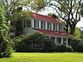
The William and Ann Copeland Jr. House is located near Shiloh. It was added to the National Register of Historic Places in 2008.

See also
 In Spanish: Shiloh (Georgia) para niños
