
Randolph County, Alabama facts for kids
Quick facts for kids
Randolph County
|
||
|---|---|---|

Randolph County Courthouse in Wedowee
|
||
|
||

Location within the U.S. state of Alabama
|
||
 Alabama's location within the U.S. |
||
| Country | ||
| State | ||
| Founded | December 18, 1832 | |
| Named for | John Randolph of Roanoke | |
| Seat | Wedowee | |
| Largest city | Roanoke | |
| Area | ||
| • Total | 584 sq mi (1,510 km2) | |
| • Land | 581 sq mi (1,500 km2) | |
| • Water | 3.6 sq mi (9 km2) 0.56% | |
| Population
(2020)
|
||
| • Total | 21,967 | |
| • Estimate
(2023)
|
22,786 |
|
| • Density | 37.61/sq mi (14.523/km2) | |
| Time zone | UTC−6 (Central) | |
| • Summer (DST) | UTC−5 (CDT) | |
| Congressional district | 3rd | |
|
||

Randolph County is a county located in the central eastern part of Alabama, a state in the United States. As of the 2020 census, about 21,967 people live here. The main town and county seat is Wedowee.
The county is named after John Randolph of Roanoke, who was an important politician from Virginia. For many years, Randolph County was a "dry county," meaning it was against the law to sell alcohol. But in 2012, people voted to change that rule.
Contents
History of Randolph County
Randolph County was officially created on December 18, 1832. This happened after the Creek people, who were Native Americans, moved from the area. The county was named to honor John Randolph, a famous politician from Virginia.
Randolph County is part of the Piedmont region. This is a hilly area that stretches from Alabama all the way to Pennsylvania. Early settlers described the county as having very clean and cold water. They also noted its gentle, rolling hills.
The first county seat was set up in 1833 at Hedgeman Triplett's Ferry. This spot was on the west side of the Big Tallapoosa River. It was about 10 miles (16 km) west of where Wedowee is today.
Moving the County Seat to Wedowee
Just two years later, in 1835, the county leaders decided to move the county seat. They chose Wedowee, which is more in the center of Randolph County. Wedowee is located on a branch of the Little Tallapoosa River.
The town of Wedowee got its name from a Creek tribal chief named "Wah-wah-nee" or "Wah-dow-wee." The town grew near where his village used to be, after the Creek people moved away.
Farming and Population Changes
Randolph County became known for farming, especially for growing cotton. Many African Americans lived and worked in the area, helping to grow these crops. After the American Civil War, many continued to live and work on farms.
However, during the early 1900s, many people, including African Americans, moved away. They were looking for new opportunities in other places. This led to a decrease in the county's population between 1920 and 1970. By 2010, about 20% of the people in Randolph County were African American.
Geography of Randolph County
Randolph County covers a total area of 584 square miles (1,510 square kilometers). Most of this area, about 581 square miles (1,500 square kilometers), is land. The rest, about 3.6 square miles (9.3 square kilometers), is water.
Neighboring Counties
Randolph County shares its borders with several other counties:
- Cleburne County to the north
- Carroll County, Georgia to the northeast
- Heard County, Georgia to the east
- Troup County, Georgia to the southeast
- Chambers County to the south
- Tallapoosa County to the southwest
- Clay County to the west
People of Randolph County (Demographics)
In 2020, there were 21,967 people living in Randolph County. There were 8,702 households and 5,720 families.
Population Details
According to the 2010 census, there were 22,913 people living in the county. The population density was about 39 people per square mile (15 people per square kilometer).
There were 9,164 households in 2010. About 27% of these households had children under 18 living with them. The average household had 2.46 people, and the average family had 2.98 people.
The population was spread out by age:
- 23.9% were under 18 years old.
- 8.2% were between 18 and 24.
- 22.9% were between 25 and 44.
- 28.0% were between 45 and 64.
- 17.0% were 65 years or older.
The average age in the county was 41.2 years. For every 100 females, there were about 94 males.
Transportation in Randolph County
Main Roads
 U.S. Highway 431
 State Route 22
 State Route 48
 State Route 77
Railroad
- CSX Transportation (a large railroad company)
Communities in Randolph County
Cities
Towns
Census-Designated Places
These are areas that are like towns but are not officially incorporated as cities or towns.
Unincorporated Communities
These are smaller communities that are not officially part of a city or town.
- Almond
- Ava
- Bacon Level
- Corinth (north)
- Corinth (south)
- Dingler
- Folsom
- Hobson
- Liberty Grove
- Louina
- Newell
- Omaha
- Potash
- Swagg
Places to Visit
Randolph County is home to Lake Wedowee. This lake is actually a part of the Tallapoosa River and is a popular spot for outdoor activities.
Images for kids
-
The official seal of Randolph County, Alabama.
-
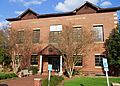
The Randolph County Courthouse in Wedowee.
See also
 In Spanish: Condado de Randolph (Alabama) para niños
