
Rock Mills, Alabama facts for kids
Quick facts for kids
Rock Mills, Alabama
|
|
|---|---|

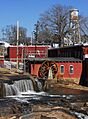
Wehadkee Creek at Rock Mills. Winter 2011.
|
|

Location in Randolph County and the state of Alabama
|
|
| Country | United States |
| State | Alabama |
| County | Randolph |
| Area | |
| • Total | 6.33 sq mi (16.39 km2) |
| • Land | 6.33 sq mi (16.38 km2) |
| • Water | 0.00 sq mi (0.01 km2) |
| Elevation | 781 ft (238 m) |
| Population
(2020)
|
|
| • Total | 603 |
| • Density | 95.34/sq mi (36.81/km2) |
| Time zone | UTC-6 (Central (CST)) |
| • Summer (DST) | UTC-5 (CDT) |
| ZIP code |
36274
|
| Area code(s) | 334 |
| FIPS code | 01-65592 |
| GNIS feature ID | 0153181 |
Rock Mills is a small community in Randolph County, Alabama, United States. It's called a census-designated place (CDP), which means it's a special area defined for counting people.
In 2010, about 600 people lived there. This was a little less than the 676 people counted in 2000. From 1890 to the 1920s, Rock Mills was an official town. It became a CDP in 2000.
Contents
Where is Rock Mills Located?
Rock Mills is located in Alabama, at these coordinates: 33°9′37″N 85°17′26″W / 33.16028°N 85.29056°W.
The U.S. Census Bureau says that the CDP covers a total area of about 6.3 square miles (16.3 square kilometers). All of this area is land.
Rock Mills Weather and Climate
The weather in Rock Mills, Alabama, has warm summers and mild winters. Here are some facts about its climate:
- The hottest month is usually July, with average high temperatures around 88.7°F (31.5°C).
- The coldest month is January, with average low temperatures around 32.2°F (0.1°C).
- The most rain usually falls in January and February.
- The driest month is often October.
- The highest temperature ever recorded was 107°F (42°C) in July.
- The lowest temperature ever recorded was -1°F (-18°C) in December.
| Climate data for Rock Mills, Alabama, 1991–2020 normals, extremes 1941–present | |||||||||||||
|---|---|---|---|---|---|---|---|---|---|---|---|---|---|
| Month | Jan | Feb | Mar | Apr | May | Jun | Jul | Aug | Sep | Oct | Nov | Dec | Year |
| Record high °F (°C) | 83 (28) |
83 (28) |
88 (31) |
92 (33) |
98 (37) |
105 (41) |
107 (42) |
104 (40) |
100 (38) |
99 (37) |
86 (30) |
80 (27) |
107 (42) |
| Mean maximum °F (°C) | 71.3 (21.8) |
74.7 (23.7) |
82.3 (27.9) |
86.1 (30.1) |
91.0 (32.8) |
95.4 (35.2) |
96.5 (35.8) |
96.4 (35.8) |
92.6 (33.7) |
87.4 (30.8) |
79.4 (26.3) |
72.6 (22.6) |
98.4 (36.9) |
| Mean daily maximum °F (°C) | 54.2 (12.3) |
60.0 (15.6) |
67.6 (19.8) |
75.3 (24.1) |
82.3 (27.9) |
87.4 (30.8) |
88.7 (31.5) |
88.8 (31.6) |
84.6 (29.2) |
75.0 (23.9) |
64.8 (18.2) |
57.1 (13.9) |
73.8 (23.2) |
| Daily mean °F (°C) | 43.2 (6.2) |
47.9 (8.8) |
54.7 (12.6) |
61.6 (16.4) |
69.6 (20.9) |
76.1 (24.5) |
78.1 (25.6) |
78.1 (25.6) |
72.9 (22.7) |
62.2 (16.8) |
52.1 (11.2) |
45.8 (7.7) |
61.9 (16.6) |
| Mean daily minimum °F (°C) | 32.2 (0.1) |
35.7 (2.1) |
41.8 (5.4) |
47.9 (8.8) |
56.8 (13.8) |
64.8 (18.2) |
67.5 (19.7) |
67.5 (19.7) |
61.1 (16.2) |
49.4 (9.7) |
39.5 (4.2) |
34.6 (1.4) |
49.9 (9.9) |
| Mean minimum °F (°C) | 13.1 (−10.5) |
19.6 (−6.9) |
23.3 (−4.8) |
30.6 (−0.8) |
41.2 (5.1) |
54.2 (12.3) |
58.9 (14.9) |
58.1 (14.5) |
47.2 (8.4) |
31.0 (−0.6) |
22.3 (−5.4) |
17.7 (−7.9) |
11.7 (−11.3) |
| Record low °F (°C) | 0 (−18) |
6 (−14) |
11 (−12) |
24 (−4) |
31 (−1) |
42 (6) |
51 (11) |
47 (8) |
32 (0) |
21 (−6) |
6 (−14) |
−1 (−18) |
−1 (−18) |
| Average precipitation inches (mm) | 5.27 (134) |
5.34 (136) |
5.23 (133) |
4.37 (111) |
4.11 (104) |
4.85 (123) |
4.47 (114) |
4.02 (102) |
3.39 (86) |
2.78 (71) |
4.12 (105) |
5.08 (129) |
53.03 (1,348) |
| Average precipitation days (≥ 0.01 in) | 9.6 | 9.3 | 8.7 | 8.0 | 7.5 | 9.8 | 11.0 | 9.2 | 6.3 | 5.9 | 5.9 | 9.2 | 100.4 |
| Source 1: NOAA | |||||||||||||
| Source 2: National Weather Service | |||||||||||||
People Living in Rock Mills
| Historical population | |||
|---|---|---|---|
| Census | Pop. | %± | |
| 1890 | 385 | — | |
| 1900 | 420 | 9.1% | |
| 1910 | 349 | −16.9% | |
| 1920 | 267 | −23.5% | |
| 2000 | 676 | — | |
| 2010 | 600 | −11.2% | |
| 2020 | 603 | 0.5% | |
| U.S. Decennial Census | |||
In 2000, there were 676 people living in Rock Mills. These people lived in 282 homes, and 192 of those were families. The community had about 107 people per square mile.
Most people in Rock Mills were White (97.63%). A smaller number were Black or African American (2.22%). About 1.63% of the people were of Hispanic or Latino background.
- About 25% of the population was under 18 years old.
- About 15% of the population was 65 years or older.
- The average age of people in Rock Mills was 38 years old.
Industries and Crafts of Rock Mills
Rock Mills has a history of important industries and crafts.
Wehadkee Mill: A Yarn and Twine Factory
The Wehadkee Mill was a factory that made yarn and twine. For many years, it provided jobs for people in Rock Mills. This mill was a big part of the community's economy.
Rock Mills Pottery: A Local Art Form
Rock Mills and nearby areas like Bacon Level, Alabama and old Cedric, Alabama were known for their pottery. Potters made useful items like:
- Urns
- Churns
- Jugs for liquids like whiskey, molasses, sugar, and milk
- Water pitchers and washing bowls
These potters are still famous today. Many potters from this area moved west to places like Mississippi and Texas. The main road for people moving west passed through here. This meant that travelers could buy the pottery they needed for their journey.
Some well-known local potters included:
- The Pittman Brothers
- The Boggs Family
- WD Pound
- Jessie Weathers
Images for kids
-
Wehadkee Creek at Rock Mills in Winter 2011.
See also
 In Spanish: Rock Mills (Alabama) para niños
