Temple, Georgia facts for kids
Quick facts for kids
Temple, Georgia
|
||
|---|---|---|

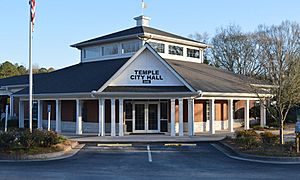
Temple City Hall
|
||
|
||

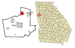
Location in Carroll County and the state of Georgia
|
||
| Country | United States | |
| State | Georgia | |
| Counties | Carroll, Haralson | |
| Area | ||
| • Total | 6.90 sq mi (17.87 km2) | |
| • Land | 6.81 sq mi (17.64 km2) | |
| • Water | 0.09 sq mi (0.23 km2) | |
| Elevation | 1,171 ft (357 m) | |
| Population
(2020)
|
||
| • Total | 5,089 | |
| • Density | 747.39/sq mi (288.56/km2) | |
| Time zone | UTC-5 (Eastern (EST)) | |
| • Summer (DST) | UTC-4 (EDT) | |
| ZIP code |
30179
|
|
| Area code(s) | 770 | |
| FIPS code | 13-75832 | |
| GNIS feature ID | 0333205 | |
Temple is a city located in the state of Georgia, in the United States. It is found in two different counties: Carroll County and Haralson County.
In 2020, about 5,089 people lived in Temple. This was a good increase from 4,228 people in 2010.
Contents
History of Temple
How Temple Got Its Name
The city of Temple got its name in 1883. This happened when a railroad line was built to the area. The city was named after a railroad official, Mr. Temple.
Later in 1883, the Georgia General Assembly officially made Temple a town. This means it became a recognized place with its own local government.
Where is Temple Located?
Geography of Temple, Georgia
Temple is in the northeastern part of Carroll County. A very small part of the city also reaches into Haralson County. The city's exact location is 33.735723 degrees North and 85.027298 degrees West.
Roads and Nearby Cities
U.S. Route 78 runs just south of the city center. You can travel east about 6 miles (10 km) to Villa Rica. If you go west, it's about 7 miles (11 km) to Bremen.
Interstate 20 also goes through the southern part of Temple. From here, you can drive about 38 miles (61 km) east to Atlanta, a much larger city. Going west on Interstate 20 will take you about 48 miles (77 km) to Oxford, Alabama. Carrollton, which is the county seat, is 12 miles (19 km) south of Temple.
Size of Temple
According to official measurements, Temple covers a total area of about 6.9 square miles (17.9 square kilometers). Most of this area, about 6.81 square miles (17.6 square kilometers), is land. A small part, about 0.09 square miles (0.2 square kilometers), is water.
Population of Temple
How Many People Live in Temple?
The number of people living in Temple has grown a lot over the years. Here's how the population has changed:
| Historical population | |||
|---|---|---|---|
| Census | Pop. | %± | |
| 1890 | 246 | — | |
| 1900 | 397 | 61.4% | |
| 1910 | 711 | 79.1% | |
| 1920 | 621 | −12.7% | |
| 1930 | 573 | −7.7% | |
| 1940 | 624 | 8.9% | |
| 1950 | 676 | 8.3% | |
| 1960 | 788 | 16.6% | |
| 1970 | 864 | 9.6% | |
| 1980 | 1,520 | 75.9% | |
| 1990 | 1,870 | 23.0% | |
| 2000 | 2,383 | 27.4% | |
| 2010 | 4,228 | 77.4% | |
| 2020 | 5,089 | 20.4% | |
| 2023 (est.) | 6,360 | 50.4% | |
| U.S. Decennial Census | |||
In 2020, there were 5,089 people living in Temple. These people lived in 1,575 households, and 1,391 of these were families.
As of 2020, all the people living in Temple resided in the Carroll County part of the city. The small part of Temple in Haralson County had no residents at that time.
Education in Temple
School Districts Serving Temple
Children living in the Carroll County part of Temple go to schools in the Carroll County School District.
If there were residents in the Haralson County part of Temple, they would attend schools in the Haralson County School District. However, as of 2020, no one lived in that section.
See also
 In Spanish: Temple (Georgia) para niños
 | Claudette Colvin |
 | Myrlie Evers-Williams |
 | Alberta Odell Jones |


