
Haralson County, Georgia facts for kids
Quick facts for kids
Haralson County
|
|
|---|---|

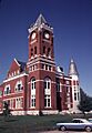
Former Haralson County Courthouse in Buchanan in 1980
|
|

Location within the U.S. state of Georgia
|
|
 Georgia's location within the U.S. |
|
| Country | |
| State | |
| Founded | January 26, 1856 |
| Named for | Hugh A. Haralson |
| Seat | Buchanan |
| Largest city | Bremen |
| Area | |
| • Total | 283 sq mi (730 km2) |
| • Land | 282 sq mi (730 km2) |
| • Water | 1.0 sq mi (3 km2) 0.4%% |
| Population
(2020)
|
|
| • Total | 29,919 |
| Time zone | UTC−5 (Eastern) |
| • Summer (DST) | UTC−4 (EDT) |
| Congressional district | 14th |
Haralson County is a county in the U.S. state of Georgia. It is located in the Northwest part of the state.
In 2020, about 29,919 people lived here. The main town, or county seat, is Buchanan. Haralson County was created on January 26, 1856. It was named after Hugh A. Haralson, who was a congressman from Georgia.
Haralson County is also part of the larger Atlanta area.
Contents
Exploring Haralson County's Geography
Haralson County covers about 283 square miles. Most of this area is land, with a small amount of water.
The county is mostly in the upper Piedmont region of Georgia. This area has rolling hills. You can also find some mountains here. These mountains are part of the foothills of the big Appalachian Mountains.
Most of the county is in the Upper Tallapoosa River area. A small part in the northwest is in the Upper Coosa River area. Both of these rivers are part of the larger ACT River Basin.
Main Roads and Highways
Many important roads run through Haralson County. These roads help people travel easily. They also connect the county to other parts of Georgia and nearby states.
 Interstate 20
 U.S. Route 27
U.S. Route 27 Business U.S. Route 78
 State Route 1
 State Route 1 Business
 State Route 8
- 20px State Route 16
 State Route 100
 State Route 113
 State Route 120
 State Route 402 (This is the official number for I-20)
Neighboring Counties
Haralson County shares borders with several other counties. These include:
- Polk County to the north
- Paulding County to the northeast
- Carroll County to the south
- Cleburne County in Alabama to the west
Population and People
The number of people living in Haralson County has grown over the years. Here's a look at the population changes:
| Historical population | |||
|---|---|---|---|
| Census | Pop. | %± | |
| 1860 | 3,039 | — | |
| 1870 | 4,004 | 31.8% | |
| 1880 | 5,972 | 49.2% | |
| 1890 | 11,316 | 89.5% | |
| 1900 | 11,922 | 5.4% | |
| 1910 | 13,514 | 13.4% | |
| 1920 | 14,440 | 6.9% | |
| 1930 | 13,263 | −8.2% | |
| 1940 | 14,377 | 8.4% | |
| 1950 | 14,663 | 2.0% | |
| 1960 | 14,543 | −0.8% | |
| 1970 | 15,927 | 9.5% | |
| 1980 | 18,422 | 15.7% | |
| 1990 | 21,966 | 19.2% | |
| 2000 | 25,690 | 17.0% | |
| 2010 | 28,780 | 12.0% | |
| 2020 | 29,919 | 4.0% | |
| 2023 (est.) | 32,038 | 11.3% | |
| U.S. Decennial Census 1790-1880 1890-1910 1920-1930 1930-1940 1940-1950 1960-1980 1980-2000 2010 2020 |
|||
Who Lives in Haralson County?
The 2020 census showed that 29,919 people lived in Haralson County. There were 11,259 households and 7,960 families.
Most people in the county are White (89.66%). About 4.19% are Black or African American. Other groups include Asian, Native American, and people of mixed races. About 1.66% of the population is Hispanic or Latino.
Education in Haralson County
Most public schools in Haralson County are part of the Haralson County School District. This district provides education for many students.
However, the City of Bremen has its own school system. It is called the Bremen City School District. Bremen is a city that is partly in Haralson County and partly in Carroll County.
Towns and Communities
Haralson County has several towns and smaller communities. These places are where people live and work.
Cities
- Bremen
- Buchanan (This is the county seat, the main town)
- Tallapoosa
- Waco
Unincorporated Communities
These are smaller communities that are not officially cities.
Images for kids
-
Former Haralson County Courthouse in Buchanan in 1980
See also
 In Spanish: Condado de Haralson para niños
