Tallapoosa, Georgia facts for kids
Quick facts for kids
Tallapoosa, Georgia
Talwa Posa
|
|||
|---|---|---|---|

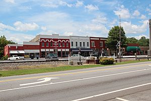
Downtown Tallapoosa
|
|||
|
|||

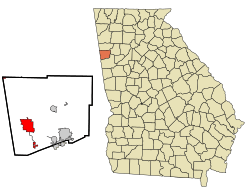
Location in Haralson County and the state of Georgia
|
|||
| Country | United States | ||
| State | Georgia | ||
| County | Haralson | ||
| Area | |||
| • Total | 10.05 sq mi (26.04 km2) | ||
| • Land | 10.03 sq mi (25.97 km2) | ||
| • Water | 0.03 sq mi (0.07 km2) | ||
| Elevation | 1,138 ft (347 m) | ||
| Population
(2020)
|
|||
| • Total | 3,227 | ||
| • Density | 321.80/sq mi (124.25/km2) | ||
| Time zone | UTC-5 (Eastern (EST)) | ||
| • Summer (DST) | UTC-4 (EDT) | ||
| ZIP code |
30176
|
||
| Area code(s) | 770 | ||
| FIPS code | 13-75300 | ||
| GNIS feature ID | 0323891 | ||
Tallapoosa /tæləˈpuːsə/ is a city in Haralson County, Georgia. It's located in the western part of the state. In 2020, about 3,227 people lived there. The city's name comes from the Tallapoosa River.
Contents
History of Tallapoosa
How Tallapoosa Got Its Name
The city of Tallapoosa was officially started as a town in 1860. Its name comes from the Tallapoosa River. The name "Tallapoosa" means "Grandmother town" or "Town of the Grandmother." This name comes from the Creek words "Talwa" (town) and "Puse" (grandmother).
The name "Tallapoosee" first appeared on Georgia maps around the 1820s. This was before the spelling became "Tallapoosa." The name shows respect for grandmothers. The native Creek and Cherokee people traced their family lines through their mothers. This is called a matrilineal system. Clan membership and traditions were passed down through the mother's side of the family.
The Role of Grandmothers in Creek Culture
The Tallapoosa branch of the Muskogee (Creek) tribe is one of the oldest groups in the Southeast. Grandmothers were very important in their communities. They were central figures in daily life. They had a big role in council meetings. People saw them as wise and full of traditional knowledge. Grandmothers helped solve problems and kept traditions alive. They also guided younger generations. They often led social and special events.
Tallapoosa as a Meeting Place
Tallapoosa was a key meeting spot for the Creek Indians. It was a central place for trade. It connected the Creek territory in the southern flatlands with the Cherokee territory in the northern Appalachian mountains.
A special historical marker in Tallapoosa is called "Seven Chestnuts." It marks where Creek Indians held their council meetings under seven chestnut trees. Another nearby marker is "Sandtown Trail." This marks a route the Creek Indians used. Later, white settlers also used it as a stagecoach route.
Fun Facts About Tallapoosa
Around 1891, Tallapoosa was sometimes called "Opossum Snout." An artist named Lyell E. Carr even made a painting with this title. Today, the city hosts a big New Year's Eve party. It's called the Possum Drop. It's one of the largest New Year's Eve celebrations in Georgia!
Geography of Tallapoosa
Tallapoosa is in the western part of Haralson County. This is in northwest Georgia. Its exact location is 33.7437 degrees North and 85.2879 degrees West.
Main Roads and Highways
Two main roads go through Tallapoosa. These are U.S. Route 78 and Georgia State Route 100. U.S. 78 runs east to west through the city. It's known as Atlanta Street. This road goes southeast about 7 miles (11 km) to Waco. It goes west about 9 miles (14 km) to Fruithurst, Alabama.
Georgia State Route 100 runs north and south through the city. It shares part of the road with U.S. 78. GA-100 goes north about 21 miles (34 km) to Cedartown. It goes south about 16 miles (26 km) to Bowdon. Interstate 20 is about 5 miles (8 km) south of the city center. You can get to it from exit 5 (GA-100). I-20 goes east about 58 miles (93 km) to Atlanta. It goes west about 99 miles (159 km) to Birmingham, Alabama.
Land and Water Area
The U.S. Census Bureau collects information about places. They say that Tallapoosa covers about 10.05 square miles (26.0 square kilometers). Most of this area is land. Only a very small part, about 0.03 square miles (0.07 square kilometers), is water.
Population of Tallapoosa
| Historical population | |||
|---|---|---|---|
| Census | Pop. | %± | |
| 1880 | 52 | — | |
| 1890 | 1,699 | 3,167.3% | |
| 1900 | 2,128 | 25.3% | |
| 1910 | 2,117 | −0.5% | |
| 1920 | 2,719 | 28.4% | |
| 1930 | 2,417 | −11.1% | |
| 1940 | 2,338 | −3.3% | |
| 1950 | 2,826 | 20.9% | |
| 1960 | 2,744 | −2.9% | |
| 1970 | 2,896 | 5.5% | |
| 1980 | 2,647 | −8.6% | |
| 1990 | 2,805 | 6.0% | |
| 2000 | 2,789 | −0.6% | |
| 2010 | 3,170 | 13.7% | |
| 2020 | 3,227 | 1.8% | |
| U.S. Decennial Census | |||
The population of Tallapoosa has changed over the years. In 1880, only 52 people lived there. By 2020, the population grew to 3,227 people. This shows how the city has grown over time.
Population in 2020
According to the 2020 United States census, there were 3,227 people living in Tallapoosa. These people lived in 1,368 households. About 789 families made their homes in the city. Most of the people living in Tallapoosa were White (89.71%). Other groups included Black or African American (4.93%), Native American (0.22%), Asian (0.56%), and people of mixed races (3.47%). About 1.12% of the population was Hispanic or Latino.
Notable People from Tallapoosa
- Leroy Almon – a famous woodcarver
- Rhubarb Jones – a well-known radio personality
See also
 In Spanish: Tallapoosa (Georgia) para niños
 | James B. Knighten |
 | Azellia White |
 | Willa Brown |


