Buchanan, Georgia facts for kids
Quick facts for kids
Buchanan, Georgia
|
|
|---|---|

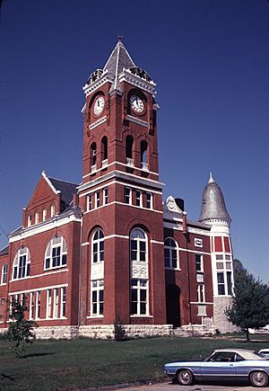
Former Haralson County courthouse in Buchanan, now the Buchanan-Haralson Public Library
|
|

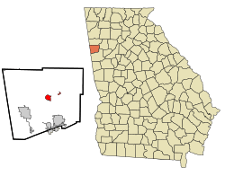
Location in Haralson County and the state of Georgia
|
|
| Country | United States |
| State | Georgia |
| County | Haralson |
| Named for | James Buchanan |
| Area | |
| • Total | 1.70 sq mi (4.40 km2) |
| • Land | 1.49 sq mi (3.86 km2) |
| • Water | 0.21 sq mi (0.54 km2) |
| Elevation | 1,243 ft (379 m) |
| Population
(2020)
|
|
| • Total | 938 |
| • Density | 629.95/sq mi (243.15/km2) |
| Time zone | UTC-5 (Eastern (EST)) |
| • Summer (DST) | UTC-4 (EDT) |
| ZIP code |
30113
|
| Area code(s) | 770 |
| FIPS code | 13-11616 |
| GNIS feature ID | 0354892 |
Buchanan is a city in Haralson County, Georgia, United States. It is also the county seat, which means it's where the main government offices for the county are located. In 2020, about 938 people lived here.
If you hear people from the area say the city's name, it sounds like "Buck-HAN-uhn."
Contents
A Look at Buchanan's History
Buchanan was started in 1856. It became the main town for the new Haralson County. The city was named after James Buchanan, who was a President of the United States.
Buchanan officially became a town in 1857. Later, in 1902, it was recognized as a city.
The Little Creek Schoolhouse
One special place in Buchanan is the Little Creek One-room Schoolhouse. This is one of the few old one-room schoolhouses still standing in Georgia. Back in 1900, there were about 7,000 of these schools across the state.
Where is Buchanan Located?
Buchanan is found in the eastern part of Haralson County. It's located at coordinates 33°48′6″N 85°11′1″W / 33.80167°N 85.18361°W.
A major road, U.S. Route 27, goes around the east side of the city. This road can take you north about 16 miles to Cedartown. If you go south, it's about 6 miles to Bremen.
The city covers a total area of about 4.4 square kilometers (1.7 square miles). Most of this area is land, while a smaller part is water.
Who Lives in Buchanan?
| Historical population | |||
|---|---|---|---|
| Census | Pop. | %± | |
| 1880 | 158 | — | |
| 1890 | 324 | 105.1% | |
| 1900 | 359 | 10.8% | |
| 1910 | 462 | 28.7% | |
| 1920 | 491 | 6.3% | |
| 1930 | 429 | −12.6% | |
| 1940 | 504 | 17.5% | |
| 1950 | 651 | 29.2% | |
| 1960 | 753 | 15.7% | |
| 1970 | 800 | 6.2% | |
| 1980 | 1,019 | 27.4% | |
| 1990 | 1,009 | −1.0% | |
| 2000 | 941 | −6.7% | |
| 2010 | 1,104 | 17.3% | |
| 2020 | 938 | −15.0% | |
| U.S. Decennial Census | |||
The number of people living in Buchanan changes over time. The 2020 United States census counted 938 people living in the city. There were 436 households and 274 families.
Different Backgrounds in Buchanan
People from many different backgrounds live in Buchanan. Here's a quick look at the racial makeup from the 2020 census:
- Most residents (about 85.5%) are White (not Hispanic).
- About 7.57% are Black or African American (not Hispanic).
- A small number (0.21%) are Asian.
- About 4.69% are from other backgrounds or a mix of races.
- About 2.03% are Hispanic or Latino.
Learning in Buchanan
The Haralson County School District manages the schools in the area. This district provides education from pre-school all the way up to twelfth grade.
Schools in the District
The Haralson County School District has several schools:
- Buchanan Elementary School
- Buchanan Primary School
- Tallapoosa Primary School
- West Haralson Elementary School
- Haralson County Middle School
- Haralson County High School
The district has over 3,766 students and 231 full-time teachers.
See also
 In Spanish: Buchanan (Georgia) para niños
 | Victor J. Glover |
 | Yvonne Cagle |
 | Jeanette Epps |
 | Bernard A. Harris Jr. |

