Calhoun County, Alabama facts for kids
Quick facts for kids
Calhoun County
|
||
|---|---|---|

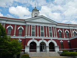
Calhoun County Courthouse in Anniston
|
||
|
||

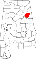
Location within the U.S. state of Alabama
|
||
 Alabama's location within the U.S. |
||
| Country | ||
| State | ||
| Founded | December 18, 1832 as Benton County |
|
| Named for | John C. Calhoun | |
| Seat | Anniston | |
| Largest city | Oxford | |
| Area | ||
| • Total | 612 sq mi (1,590 km2) | |
| • Land | 606 sq mi (1,570 km2) | |
| • Water | 6.4 sq mi (17 km2) 1.0% | |
| Population
(2020)
|
||
| • Total | 116,441 | |
| • Estimate
(2023)
|
116,429 |
|
| • Density | 190.26/sq mi (73.46/km2) | |
| Time zone | UTC−6 (Central) | |
| • Summer (DST) | UTC−5 (CDT) | |
| Congressional district | 3rd | |
|
||
Calhoun County is a county in the east-central part of the state of Alabama. In 2020, about 116,441 people lived there. Its main city, or county seat, is Anniston. The county is named after John C. Calhoun, who was a US Senator from South Carolina.
Calhoun County is part of the Anniston-Oxford Metropolitan Statistical Area. This means it's a busy area with cities and towns that are closely connected.
Contents
History of Calhoun County
Calhoun County was first created on December 18, 1832. It was originally called Benton County. It was named after Thomas Hart Benton, a US Senator from Missouri. The first county seat was Jacksonville.
Thomas Hart Benton and John C. Calhoun were both important politicians. However, over time, they started to disagree on big issues facing the country. Calhoun strongly believed in states' rights and wanted to protect certain traditions. Benton, on the other hand, became more focused on keeping the United States together as one nation.
Because of these disagreements, people in Alabama who supported Calhoun's ideas decided to rename the county. On January 29, 1858, Benton County became Calhoun County.
Later, in 1900, the county seat was moved from Jacksonville to Anniston. This happened after a long debate and a decision by the State Supreme Court.
On March 27, 1994, a very strong tornado, called an F4 tornado, hit the area. It caused a lot of damage, including destroying a church in Piedmont.
Geography of Calhoun County
Calhoun County covers about 612 square miles (1,585 square kilometers). Most of this area, about 606 square miles, is land. The rest, about 6.4 square miles, is water.
Neighboring Counties
Calhoun County shares borders with these other counties:
- Cherokee County - to the northeast
- Cleburne County - to the east
- Talladega County - to the south
- St. Clair County - to the west
- Etowah County - to the northwest
Protected Natural Areas
You can find parts of these special natural places in Calhoun County:
- Mountain Longleaf National Wildlife Refuge
- Talladega National Forest
Transportation in Calhoun County
Calhoun County has many ways to get around, including major highways and railways.
Main Highways
 Interstate 20
 U.S. Highway 78
 U.S. Highway 278
 U.S. Highway 431
 State Route 9
 State Route 21
 State Route 144
 State Route 200
 State Route 202
 State Route 204
 State Route 301
Railways
- Alabama and Tennessee River Railway
- Norfolk Southern Railway
- Amtrak (the Crescent train line)
Local Transit
- Areawide Community Transportation System
Population of Calhoun County
| Historical population | |||
|---|---|---|---|
| Census | Pop. | %± | |
| 1840 | 14,260 | — | |
| 1850 | 17,163 | 20.4% | |
| 1860 | 21,539 | 25.5% | |
| 1870 | 13,980 | −35.1% | |
| 1880 | 19,591 | 40.1% | |
| 1890 | 33,835 | 72.7% | |
| 1900 | 34,874 | 3.1% | |
| 1910 | 39,115 | 12.2% | |
| 1920 | 47,822 | 22.3% | |
| 1930 | 55,611 | 16.3% | |
| 1940 | 63,319 | 13.9% | |
| 1950 | 79,539 | 25.6% | |
| 1960 | 95,878 | 20.5% | |
| 1970 | 103,092 | 7.5% | |
| 1980 | 119,761 | 16.2% | |
| 1990 | 116,034 | −3.1% | |
| 2000 | 112,249 | −3.3% | |
| 2010 | 118,572 | 5.6% | |
| 2020 | 116,441 | −1.8% | |
| 2023 (est.) | 116,429 | −1.8% | |
| U.S. Decennial Census 1790–1960 1900–1990 1990–2000 2010–2020 |
|||
As of the 2020 census, there were 116,441 people living in Calhoun County. The county is home to many different groups of people.
Education in Calhoun County
Calhoun County has several public school districts. About 17,000 students attend public schools from kindergarten through 12th grade.
The county also has two public colleges:
- Gadsden State Community College has a campus in Anniston.
- Jacksonville State University is located in Jacksonville. It was founded in 1883 and has over 9,000 students.
School Districts
Here are the public school districts in Calhoun County:
- Anniston City School District
- Calhoun County School District
- Jacksonville City School District
- Oxford City School District
- Piedmont City School District
Communities in Calhoun County
Calhoun County has many different cities, towns, and smaller communities.
Cities
- Anniston (This is the county seat)
- Glencoe (partly in Etowah County)
- Jacksonville
- Oxford (partly in Talladega County and Cleburne County)
- Piedmont (partly in Cherokee County)
- Southside (partly in Etowah County)
- Weaver
Towns
Census-Designated Places (CDPs)
These are areas that are like towns but are not officially incorporated as cities or towns.
Unincorporated Communities
These are smaller communities that are not part of any city or town.
Ghost Towns
These are places that used to be towns but are now abandoned.
Places to Visit in Calhoun County
Calhoun County has many interesting places to visit:
- Jacksonville State University
- The Anniston Museum of Natural History
- The Berman Museum of World History
- The Coldwater Covered Bridge
- A part of the Talladega National Forest
See also
 In Spanish: Condado de Calhoun (Alabama) para niños
 | Janet Taylor Pickett |
 | Synthia Saint James |
 | Howardena Pindell |
 | Faith Ringgold |


