
Calera, Alabama facts for kids
Quick facts for kids
Calera
|
||
|---|---|---|
| Calera, Alabama | ||

The Calera Downtown Historic District was listed on the National Register of Historic Places on March 29, 2006.
|
||
|
||

Location of Calera in Chilton County and Shelby County, Alabama.
|
||

Calera
Location in the United States
|
||
| Country | United States | |
| State | Alabama | |
| Counties | Chilton, Shelby | |
| Area | ||
| • Total | 24.47 sq mi (63.38 km2) | |
| • Land | 24.21 sq mi (62.70 km2) | |
| • Water | 0.26 sq mi (0.68 km2) | |
| Elevation | 558 ft (170 m) | |
| Population
(2020)
|
||
| • Total | 16,494 | |
| • Density | 681.32/sq mi (263.05/km2) | |
| Time zone | UTC-6 (CST) | |
| • Summer (DST) | UTC-5 (CDT) | |
| ZIP code |
35040
|
|
| Area code(s) | 205, 659 | |
| FIPS code | 01-11416 | |
| GNIS feature ID | 2403965 | |

Calera is a city in Alabama, located in both Shelby and Chilton counties. It is also home to the Shelby County Airport.
In 2010, Calera had about 11,620 people. This was a huge jump from 2000, making it Alabama's fastest-growing city! Calera is part of the larger Birmingham area. By 2020, the population had grown even more, reaching 16,494 residents.
Contents
Exploring Calera's Location
Calera is in the southern part of Shelby County. Its city limits stretch south into Chilton County. The main highway through the city is U.S. Route 31.
Major Highways in Calera
Interstate 65 runs along the eastern side of Calera. You can get on or off I-65 at exits 228, 231, and 234.
- Birmingham is about 34 miles (55 km) north.
- Montgomery is about 59 miles (95 km) south.
Both cities are easily reached via I-65.
Calera's Size and Water Areas
The city covers a total area of about 24.47 square miles (63.38 square kilometers). Most of this area is land, about 24.21 square miles (62.70 square kilometers). A small part, about 0.26 square miles (0.68 square kilometers), is water.
The History of Calera
.jpg)
The city of Calera was officially started in 1887. Its name comes from a Spanish word meaning "quarry." This name was chosen because there were many limestone deposits in the area. Limestone is a type of rock often found in quarries.
Calera's Growing Population
Calera has seen a lot of growth over the years.
| Historical population | |||
|---|---|---|---|
| Census | Pop. | %± | |
| 1880 | 234 | — | |
| 1890 | 753 | 221.8% | |
| 1900 | 770 | 2.3% | |
| 1910 | 754 | −2.1% | |
| 1920 | 852 | 13.0% | |
| 1930 | 975 | 14.4% | |
| 1940 | 1,092 | 12.0% | |
| 1950 | 1,361 | 24.6% | |
| 1960 | 1,928 | 41.7% | |
| 1970 | 1,655 | −14.2% | |
| 1980 | 2,035 | 23.0% | |
| 1990 | 2,136 | 5.0% | |
| 2000 | 3,158 | 47.8% | |
| 2010 | 11,620 | 268.0% | |
| 2020 | 16,494 | 41.9% | |
| U.S. Decennial Census | |||
Who Lives in Calera? (2010 Census)
In 2010, there were 11,620 people living in Calera.
- About 71.2% of the people were White.
- About 23.0% were Black or African American.
- About 5.0% of the population identified as Hispanic or Latino.
- The average age of people in Calera was about 31.9 years old.
- About 26.5% of the population was under 18 years old.
Who Lives in Calera? (2020 Census)
By 2020, Calera's population had grown to 16,494 people.
| Race | Num. | Perc. |
|---|---|---|
| White (non-Hispanic) | 9,264 | 56.17% |
| Black or African American (non-Hispanic) | 5,205 | 31.56% |
| Native American | 31 | 0.19% |
| Asian | 134 | 0.81% |
| Pacific Islander | 3 | 0.02% |
| Other/Mixed | 816 | 4.95% |
| Hispanic or Latino | 1,041 | 6.31% |
Famous People from Calera
Some well-known people have connections to Calera:
- Shanavia Dowdell: A professional basketball player.
- Hut Stricklin: A former NASCAR driver.
- Virgil Trucks: A famous Major League Baseball pitcher.
Fun Places to Visit in Calera
Calera has several interesting spots:
- Shelby County Airport
- Heart of Dixie Railroad Museum: A great place to see old trains.
- George Roy Park
- Oliver Park
- Timberline Golf Course
- Calera Presbyterian Church
Calera's Weather and Climate
Calera has a climate with hot, humid summers. Winters are usually mild to cool. This type of weather is called a humid subtropical climate. The local National Weather Service office, which forecasts weather for the Birmingham area, is located in Calera.
| Climate data for Calera, Alabama | |||||||||||||
|---|---|---|---|---|---|---|---|---|---|---|---|---|---|
| Month | Jan | Feb | Mar | Apr | May | Jun | Jul | Aug | Sep | Oct | Nov | Dec | Year |
| Mean daily maximum °C (°F) | 12 (54) |
16 (60) |
19 (67) |
25 (77) |
28 (83) |
32 (89) |
33 (92) |
33 (91) |
30 (86) |
25 (77) |
19 (66) |
14 (58) |
24 (75) |
| Mean daily minimum °C (°F) | −1 (31) |
1 (33) |
5 (41) |
9 (48) |
13 (55) |
17 (63) |
19 (67) |
19 (66) |
16 (61) |
9 (48) |
4 (39) |
1 (33) |
9 (49) |
| Average precipitation mm (inches) | 130 (5.1) |
130 (5.3) |
170 (6.5) |
130 (5.2) |
100 (4) |
110 (4.2) |
140 (5.4) |
110 (4.2) |
97 (3.8) |
71 (2.8) |
94 (3.7) |
130 (5.1) |
1,400 (55.1) |
| Source: Weatherbase | |||||||||||||
Getting Around Calera
Chilton County Transit offers a dial-a-ride bus service in the city. This means you can call and arrange for a bus to pick you up.
Gallery
-
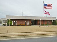
Calera City Hall
-
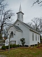
The Calera Presbyterian Church was built in 1885. The church building is now owned by the city. It was added to the Alabama Register of Landmarks and Heritage on March 12, 1997.
-
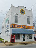
The Cowart Drug Store was built in 1885. It was added to the Alabama Register of Landmarks and Heritage on February 15, 1977.


See also
 In Spanish: Calera (Alabama) para niños
