Dunnavant, Alabama facts for kids
Quick facts for kids
Dunnavant, Alabama
|
|
|---|---|

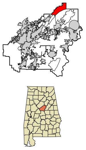
Location of Dunnavant in Shelby County, Alabama.
|
|
| Country | United States |
| State | Alabama |
| County | Shelby |
| Area | |
| • Total | 20.27 sq mi (52.51 km2) |
| • Land | 19.26 sq mi (49.87 km2) |
| • Water | 1.02 sq mi (2.64 km2) |
| Elevation | 666 ft (203 m) |
| Population
(2020)
|
|
| • Total | 936 |
| • Density | 48.61/sq mi (18.77/km2) |
| Time zone | UTC-6 (Central (CST)) |
| • Summer (DST) | UTC-5 (CDT) |
| Area code(s) | 205, 659 |
| GNIS feature ID | 117649 |
Dunnavant, sometimes spelled Dunavant, is a small community in Shelby County, Alabama, in the United States. It is known as a census-designated place, which means it's an area that looks like a town but isn't officially governed as one. It's also an unincorporated community, meaning it doesn't have its own local government like a city or town.
In 2010, about 981 people lived there. The name "Dunnavant" likely comes from a family who lived in the area a long time ago. This community even had its own post office from 1897 until 1958.
Dunnavant is found in the middle part of Alabama. It sits in the southern edges of the Appalachian Mountains. You can find it along Alabama State Route 25 and Shelby County Road 41.
If you travel north from Dunnavant, you'll reach Leeds in about 6 miles (10 kilometers). To the southeast, about 4 miles (6 kilometers) away, is the community of Vandiver. This route is quite winding and goes through mountains! If you head southwest on Shelby County 41, also known as Dunnavant Valley Road, you'll get to Chelsea in about 15 miles (24 kilometers).
Just like many places, Dunnavant's population changes over time. Here's how many people have lived there according to the official U.S. Census:
| Historical population | |||
|---|---|---|---|
| Census | Pop. | %± | |
| 2020 | 936 | — | |
| U.S. Decennial Census | |||
In 2020, the population of Dunnavant was 936 people. This number helps us understand how the community is growing or changing.
See also
 In Spanish: Dunnavant (Alabama) para niños
 | Claudette Colvin |
 | Myrlie Evers-Williams |
 | Alberta Odell Jones |


