
Wetumpka, Alabama facts for kids
Quick facts for kids
Wetumpka
|
|
|---|---|
 |
|

Location of Wetumpka in Elmore County, Alabama.
|
|
| Country | United States |
| State | Alabama |
| County | Elmore |
| Government | |
| • Type | Mayor/Council |
| Area | |
| • Total | 11.39 sq mi (29.51 km2) |
| • Land | 10.95 sq mi (28.37 km2) |
| • Water | 0.44 sq mi (1.14 km2) |
| Elevation | 185 ft (56 m) |
| Population
(2020)
|
|
| • Total | 7,220 |
| • Density | 659.12/sq mi (254.48/km2) |
| Time zone | UTC-6 (Central (CST)) |
| • Summer (DST) | UTC-5 (CDT) |
| ZIP Codes |
36092-36093
|
| Area code(s) | 334 |
| FIPS code | 01-81720 |
| GNIS feature ID | 0155305 |
Wetumpka is a city in Elmore County, Alabama. It is also the county seat, which means it is the main city where the county government is located. In 2020, about 7,220 people lived here. Elmore County has been growing very fast. Wetumpka is part of the larger Montgomery Metropolitan Area.
Wetumpka calls itself "The City of Natural Beauty." It has cool places like the Wetumpka crater, which was made by a meteorite. There are also the Jasmine Hill Gardens, which used to have a full-sized copy of the Temple of Hera from ancient Greece. The old downtown area of Wetumpka is built on both sides of the Coosa River. Long ago, the French built Fort Toulouse nearby in 1717.
Contents
What's in a Name?
The name Wetumpka comes from the Creek Native American language. It means "rumbling waters." This name likely describes the sound of the Coosa River rapids, especially at a spot called the Devil's Staircase. People say the sound of the rapids could be heard for miles. This was before dams like the Walter Bouldin Dam were built in the 1900s.
Later, when the Muscogee people were forced to move west to what is now Oklahoma, they named a new settlement Wetumka. They did this to remember their old village.
Wetumpka's Past
The Muscogee people lived in this area for a very long time. Their biggest towns were along the Coosa River and where it met the Tallapoosa River. These places were Wetumpka and Talisi (now Tallassee).
Early European Settlers

In the early 1700s, French colonists came to the area. They wanted to set up a fort to trade with the Creek people. They also wanted to stop British colonists from moving into their land. Jean-Baptiste Le Moyne ordered Fort Toulouse to be built in 1714. It was about 4 miles (6.4 km) from where the Coosa and Tallapoosa rivers meet. This was a very important spot for a fort.
The French traded at Wetumpka and kept soldiers at Fort Toulouse until 1763. Then, they gave the land to the British after losing a war. The British controlled this area for almost 25 years. Some Scottish and Irish traders married into the Creek families. Their children became important Creek leaders.
United States Takes Over

After the American Revolutionary War, Britain gave this land to the United States in 1783. In 1798, it became part of the Mississippi Territory. Around 1800, European-American settlers started arriving. Many brought enslaved African-American people to work for them. These settlers began to move onto the lands of the Native American tribes.
In the early 1800s, there were disagreements among the Creek people. Some wanted to keep their old traditions. Others, especially those who traded with the European Americans, adopted more of their ways. In 1811, a Shawnee chief named Tecumseh asked the Creek to join him. He wanted to unite Native American tribes to stop settlers from moving west.
When the U.S. went to war with Britain in 1812, the Creek who wanted to fight lost British support. But they kept fighting against American settlers. After a terrible event at Fort Mims, settlers asked for help. General Andrew Jackson led soldiers from Tennessee, Mississippi, and Georgia. They attacked the Creek in Alabama.

Jackson's forces won a big battle at Horseshoe Bend. He then went to Fort Toulouse and had it fixed. The fort was renamed Fort Jackson in his honor.
Jackson used the fort as his main base during the War of 1812. The Creek people who lost the war had to sign the Treaty of Fort Jackson in 1814. This treaty made them give up a huge amount of their land to the United States. After the war, many of Jackson's soldiers came back to settle near the fort.
Growing into a City
Settlers, mostly from Georgia and the Carolinas, moved into the rich land that the Creek had to leave. Wetumpka was in a great spot where rivers met. It quickly became a busy center for farming trade. The city officially became a town in 1834.
Cotton was the most important crop in Alabama. People grew a type of cotton that was easier to process thanks to Eli Whitney's cotton gin. Cotton from farms was brought to Wetumpka. From there, it was loaded onto steamboats. These boats traveled down the Coosa River to markets in Mobile to be sold.
Wetumpka grew very fast because of cotton. The city was split into two parts. The east side of the river was for businesses, with banks, stores, and hotels. The west side was for homes and churches.
By 1836, Wetumpka had 1,200 people. Some even said it was one of the most promising cities in the West. The city had its own steamboat, The Coosa Belle, to carry people and cotton to Mobile.
Wetumpka almost became the capital of Alabama. It was a strong choice along with Montgomery. But Montgomery won the vote. A big fire also happened in Wetumpka, burning many buildings. The bricks from these burned buildings were taken to Montgomery to help build Alabama's new capital.
Challenges and Progress
Even though Wetumpka didn't become the capital, its farmers and merchants did well before the American Civil War. They wanted to build a lock and dam so boats could travel further up the Coosa River. A famous person from Wetumpka was William Lowndes Yancey. He was a newspaper editor and politician who strongly believed that Southern states should be able to leave the United States.
In 1861, Southern states met in Montgomery to form the Confederate government. Most of Wetumpka's men went off to fight in the war. Wetumpka itself was not attacked by Union troops during the war.
After the war, the city's economy was ruined. In 1866, Elmore County was created from parts of other counties, and Wetumpka became its county seat. The city's population dropped a lot after the war. It didn't get back to its pre-war size until the 1950s.
In 1886, a terrible flood hit Wetumpka. It washed away the bridge connecting the two parts of the city. It took over a year to replace it.
Modern Wetumpka

The first paved road connecting Wetumpka to Montgomery was finished in 1924. As cars became common, people from Wetumpka could easily drive to Montgomery for work.
In 2022, two women who were helping stray cats in Wetumpka faced legal issues. The city later decided not to continue with the charges. These women, Beverly Roberts and Mary Alston, were even called "community heroes" for their efforts.
Where is Wetumpka?
Wetumpka is in the southwest part of Elmore County. It is on both sides of the Coosa River. This is about 5 miles (8 km) northeast of where the Coosa and Tallapoosa rivers join to form the Alabama River.
The city is located where the Appalachian foothills meet the flat Gulf Coastal Plain. This area is called the Fall Line.
Many important roads pass through Wetumpka. U.S. Route 231 goes north to Rockford and south to Montgomery. Alabama State Route 14 goes east to Tallassee and southwest to Prattville.
Downtown Wetumpka is next to the Coosa River. The Bibb Graves Bridge crosses the river and is a famous landmark. Right across the bridge are three old churches: First Methodist, First Presbyterian, and First Baptist. In 2019, a tornado damaged some of these churches.
The city has a total area of about 11.39 square miles (29.51 km2). Most of this is land, and a small part is water.
Wetumpka's Weather
Wetumpka has a humid subtropical climate. This means it has hot, humid summers and mild to cool winters.
| Climate data for Wetumpka, 1991–2020 normals, extremes 1896–2017 | |||||||||||||
|---|---|---|---|---|---|---|---|---|---|---|---|---|---|
| Month | Jan | Feb | Mar | Apr | May | Jun | Jul | Aug | Sep | Oct | Nov | Dec | Year |
| Record high °F (°C) | 85 (29) |
88 (31) |
91 (33) |
95 (35) |
104 (40) |
108 (42) |
108 (42) |
106 (41) |
107 (42) |
99 (37) |
90 (32) |
82 (28) |
108 (42) |
| Mean daily maximum °F (°C) | 57.9 (14.4) |
62.4 (16.9) |
70.0 (21.1) |
77.0 (25.0) |
84.4 (29.1) |
89.8 (32.1) |
92.1 (33.4) |
91.6 (33.1) |
87.6 (30.9) |
78.3 (25.7) |
68.0 (20.0) |
60.3 (15.7) |
76.6 (24.8) |
| Daily mean °F (°C) | 47.1 (8.4) |
50.9 (10.5) |
57.9 (14.4) |
64.8 (18.2) |
72.9 (22.7) |
79.5 (26.4) |
82.0 (27.8) |
81.5 (27.5) |
77.0 (25.0) |
66.6 (19.2) |
55.8 (13.2) |
49.3 (9.6) |
65.4 (18.6) |
| Mean daily minimum °F (°C) | 36.1 (2.3) |
39.6 (4.2) |
45.9 (7.7) |
52.5 (11.4) |
61.3 (16.3) |
69.3 (20.7) |
72.1 (22.3) |
71.4 (21.9) |
66.4 (19.1) |
54.9 (12.7) |
43.5 (6.4) |
38.5 (3.6) |
54.3 (12.4) |
| Record low °F (°C) | 8 (−13) |
−7 (−22) |
20 (−7) |
29 (−2) |
39 (4) |
48 (9) |
55 (13) |
53 (12) |
40 (4) |
28 (−2) |
12 (−11) |
12 (−11) |
−7 (−22) |
| Average precipitation inches (mm) | 4.97 (126) |
5.35 (136) |
5.63 (143) |
4.21 (107) |
3.73 (95) |
4.95 (126) |
5.15 (131) |
4.35 (110) |
3.39 (86) |
2.81 (71) |
3.85 (98) |
4.91 (125) |
53.30 (1,354) |
| Average snowfall inches (cm) | 0.0 (0.0) |
0.0 (0.0) |
0.3 (0.76) |
0.0 (0.0) |
0.0 (0.0) |
0.0 (0.0) |
0.0 (0.0) |
0.0 (0.0) |
0.0 (0.0) |
0.0 (0.0) |
0.0 (0.0) |
0.0 (0.0) |
0.3 (0.76) |
| Average precipitation days (≥ 0.01 in) | 9.4 | 9.1 | 8.5 | 6.9 | 6.7 | 9.6 | 10.7 | 9.6 | 6.1 | 6.2 | 6.9 | 8.8 | 98.5 |
| Average snowy days (≥ 0.1 in) | 0.0 | 0.0 | 0.1 | 0.0 | 0.0 | 0.0 | 0.0 | 0.0 | 0.0 | 0.0 | 0.0 | 0.0 | 0.1 |
| Average dew point °F (°C) | 37.8 (3.2) |
40.6 (4.8) |
45.5 (7.5) |
52.7 (11.5) |
61.2 (16.2) |
68.4 (20.2) |
71.4 (21.9) |
70.9 (21.6) |
66.0 (18.9) |
55.9 (13.3) |
45.9 (7.7) |
41.0 (5.0) |
54.8 (12.7) |
| Source 1: PRISM Climate Group | |||||||||||||
| Source 2: NOAA | |||||||||||||
People of Wetumpka
| Historical population | |||
|---|---|---|---|
| Census | Pop. | %± | |
| 1850 | 3,824 | — | |
| 1870 | 1,137 | — | |
| 1880 | 816 | −28.2% | |
| 1890 | 619 | −24.1% | |
| 1900 | 562 | −9.2% | |
| 1910 | 1,103 | 96.3% | |
| 1920 | 1,520 | 37.8% | |
| 1930 | 2,357 | 55.1% | |
| 1940 | 3,089 | 31.1% | |
| 1950 | 3,813 | 23.4% | |
| 1960 | 3,672 | −3.7% | |
| 1970 | 3,912 | 6.5% | |
| 1980 | 4,341 | 11.0% | |
| 1990 | 4,670 | 7.6% | |
| 2000 | 5,726 | 22.6% | |
| 2010 | 6,528 | 14.0% | |
| 2020 | 7,220 | 10.6% | |
| U.S. Decennial Census | |||
2020 Population Details
| Race | Num. | Perc. |
|---|---|---|
| White (not Hispanic) | 4,624 | 64.04% |
| Black or African American (not Hispanic) | 1,898 | 26.29% |
| Native American | 44 | 0.61% |
| Asian | 90 | 1.25% |
| Pacific Islander | 9 | 0.12% |
| Other/Mixed | 261 | 3.61% |
| Hispanic or Latino | 294 | 4.07% |
In 2020, there were 7,220 people living in Wetumpka. There were 2,917 households and 2,008 families.
2010 Population Details
In 2010, Wetumpka had 6,528 people and 2,206 households. About 64.88% of the people were White, and 32.83% were Black or African American.
About 18.4% of the people were under 18 years old. The average age was 38 years.
Fun Facts About Wetumpka
Wetumpka on TV and in Movies
In 2020, Wetumpka was chosen for HGTV's show Home Town Takeover. The show helped to fix up 12 buildings and public spaces in the city. It started airing in May 2021.
Four major movies have been filmed in downtown Wetumpka:
- The Grass Harp (1995)
- The Rosa Parks Story (2002)
- Big Fish (2003)
- Son of the South (2020)
The Wetumpka Meteor Crater
Wetumpka is home to a very special natural site. About 80 million years ago, a meteorite hit the area. It was about 1,000 feet (300 m) wide! The hills east of downtown are what's left of a 5-mile (8 km) wide impact crater. This area is called the Wetumpka crater or an astrobleme (which means "star-wound").
In 2002, scientists from Auburn University found proof that it was a real impact crater. They think the energy from the impact was like 175,000 times the energy of the nuclear bomb used in Hiroshima in 1945.
Jasmine Hill Gardens
This outdoor museum was built in the 1930s. The Fitzpatrick family, who owned the land, collected copies of ancient Greek statues. They used these to decorate their beautiful gardens. The gardens are now closed.
Outdoor Fun

Wetumpka and the Coosa River are great for outdoor activities. The Coosa River Challenge is an annual event that started in 2003. It's like a triathlon with a cross country run, mountain bike ride, and paddling on the Coosa River.
The Swayback Bridge Trail also hosts a yearly mountain bike race called "Attack on Swayback."
Wetumpka is popular for white water sports. People from all over the country come to paddle here. The city hosts the annual Coosa River Whitewater Festival. The Coosa River Paddling Club has built Corn Creek Park. It's a public place to get to the river and has nature trails.
Christmas on the Coosa
Christmas on the Coosa is a fun event held every December. The main part is a fireworks show and boat parade on the Coosa River, near the Bibb Graves Memorial Bridge. Boats decorated with Christmas lights float down the river. The fireworks light up the sky and reflect on the calm water. Before the river show, there are other events like a pageant, pictures with Santa, and a tree lighting at Goldstar Park.
Poarch Creek Casino
The Poarch Band of Creek Indians has built a casino next to the city. They plan to make it much bigger, adding a hotel and more attractions. This new complex will create many jobs.
City Services
The United States Postal Service has a post office in Wetumpka.
The Julia Tutwiler Prison for Women is in Wetumpka. This prison houses female inmates in Alabama.
Schools in Wetumpka
The city's schools are part of the Elmore County Public School System.
Public schools include Wetumpka Elementary School, Wetumpka Middle School, Wetumpka High School, and Redland Elementary School. Wetumpka Middle School was created by combining two other schools.
Famous People from Wetumpka
- James Anderson, actor in To Kill a Mockingbird
- William B. Bryant, a United States federal judge
- James Daniel, a football coach for the Pittsburgh Steelers
- John Kelly Fitzpatrick, a painter
- Hanley Funderburk, former president of Auburn University
- Robert D. Glass, the first African American justice on the Connecticut Supreme Court
- Lewis Jackson, head basketball coach for Alabama State University
- Jean Baptiste Louis DeCourtel Marchand, a French soldier
- Jason McLaughlin, a soccer player
- Charles McMorris, a US vice admiral
- Benjamin White Norris, a congressman
- Frank Oliver, a former NFL player
- Blake Percival, a whistleblower
- Jim Rogers, a businessman and author
- Jason Sanford, a science-fiction author
- Elizabeth Spiers, a writer and editor
- Monica Lisa Stevenson, a gospel musician
- Channing Tatum, actor, spent part of his childhood here
- Tevin Washington, a football player for Georgia Tech
- Thomas Williams, a congressman
- Jamie Winborn, a pro football player
- Jessica Meuse, a singer from American Idol
- William Lowndes Yancey, a politician
- John Q. Loomis, a Confederate army officer
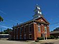
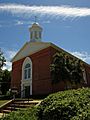
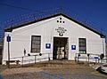
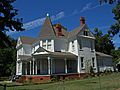
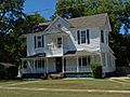
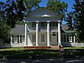
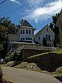
Buildings in Wetumpka
-
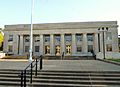
The Elmore County Courthouse.
-

Wetumpka City Hall.
-
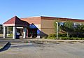
The Wetumpka Post Office.
-
First United Methodist Church of Wetumpka.
-
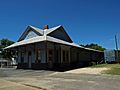
The Wetumpka L&N Depot, built in 1906.
-
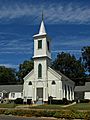
First Presbyterian Church of Wetumpka.
-
First Baptist Church of Wetumpka.
-
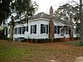
The Abel Hagerty House.
-
Julia Tutwiler Prison for Women.
-
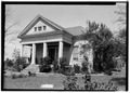
John Bruce Airey House.
-
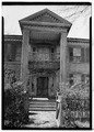
Kelly Fitzpatrick House.
-
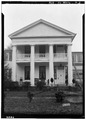
Paul M. Bates House (Bates-Jesse House).
-
John Bullard House (1823).
-
Benjamin Fitzpatrick House.
-

House, 400 E Tallassee Street.
-
House, 307 NW Main Street.
-
Florence Bateman House.
-
McCowen House.


See also
 In Spanish: Wetumpka para niños
