
Troy, Alabama facts for kids
Quick facts for kids
Troy, Alabama
|
||
|---|---|---|
|
County seat and City
|
||

Historic Downtown Square of Troy
|
||
|
||
| Nickname(s):
T-Town, T-Roy
|
||
| Motto(s):
"A Wonderful Place to Live!"
|
||

Location of Troy in Pike County, Alabama.
|
||

Troy, Alabama
Location in the United States
|
||
| Country | United States | |
| State | Alabama | |
| County | Pike | |
| Founded | 1838 | |
| Incorporated | 1843 | |
| Government | ||
| • Type | Mayor-Council | |
| Area | ||
| • Total | 28.42 sq mi (73.61 km2) | |
| • Land | 28.34 sq mi (73.41 km2) | |
| • Water | 0.08 sq mi (0.21 km2) | |
| Elevation | 541 ft (165 m) | |
| Population
(2020)
|
||
| • Total | 17,727 | |
| • Density | 625.45/sq mi (241.49/km2) | |
| Time zone | UTC-6 (CST) | |
| • Summer (DST) | UTC-5 (CDT) | |
| ZIP codes |
36079, 36081, 36082
|
|
| Area code | 334 | |
| FIPS code | 01-76920 | |
| GNIS feature ID | 0153725 | |

Troy is a city in Alabama, United States. It is the main city and county seat of Pike County. The city was officially started on February 4, 1843.
Before 1783, the land where Troy is now was part of a British colony called British West Florida. After 1783, it became part of the United States.
In 2020, about 17,727 people lived in Troy. This was a small decrease from 18,033 people in 2010. Troy is known for being home to Troy University. This is the fourth-largest university in Alabama.
Contents
- History of Troy: From Early Days to Today
- Geography of Troy
- Climate in Troy
- People and Population in Troy
- Education in Troy
- Culture and Events in Troy
- Economy and Jobs in Troy
- Infrastructure and Transportation
- Media in Troy
- Notable People from Troy
- Points of Interest in Troy
- Images for kids
- See also
History of Troy: From Early Days to Today
Early Settlements and Native American Life
For many centuries, different Native American tribes lived around the Troy area. The Muskogee Creek people were especially well-known here. Most Creek tribes lived near rivers and streams. In the Troy area, many settled near the Conecuh River and the Pea River.
European explorers and colonists later claimed this land. Spain, France, and Great Britain all had claims. But very few Europeans actually settled far inland. The United States gained control of the region from Spain in 1795. This led to the creation of the Mississippi Territory in 1798.
In 1819, Alabama became a state. Soon after, counties were organized. Pike County was one of the first, created in 1821. It was so large that people called it the "State of Pike." It included parts of several other counties we know today.
How Troy Became a City
The land that became Troy was settled in the early 1830s. It was first known as Deer Stand Hill, an old Native American hunting ground. Then it was called Zebulon, and later Centreville. Finally, in 1838, it was named Troy.
Troy became the county seat that same year. A new courthouse was built in 1839. This replaced Monticello as the main town. Hotels, taverns, and small shops quickly made Troy a busy center. Sadly, a big fire in 1901 destroyed much of the town. Troy had to be rebuilt. The courthouse was moved one block away from the town square.
Important Roads and Early Conflicts
An important road called the Federal Road was built after 1805. It helped settlers move and mail travel faster. In 1824, another military road was built. This road ran through Troy and Pike County. It became known as the Three Notch Road. It helped many settlers move into southern Alabama and northern Florida.
During this time, there were growing tensions between local Creek Indians and European settlers. As settlers moved onto Creek lands, the Creeks began to fight back. This was part of the Second Indian War in the Southeastern United States.
Battle of Hobdy's Bridge (1837)
On February 10, 1837, a group of American soldiers fought about 75 Creeks. The Creeks were trying to reach Florida. The soldiers found the Creek camp and attacked.
The Creeks used fallen trees for protection. They were low on supplies and even fired nails instead of bullets. The soldiers eventually took over the camp. They found items that had been taken from nearby farms. A few Creeks and one American soldier were killed. Even though they lost their supplies, the Creeks kept trying to escape.
Battle of Pea River (1837)
One of the last battles of the Second Creek War happened on March 27, 1837. It was about 17 miles east of Troy. Over 250 American soldiers tracked about 400 Creek people, including women and children. The Creeks were angry that their land was being taken. They burned homes and farms along the Pea River.
The soldiers found the Creek camp in a swamp. A fierce four-hour battle began. The Creek warriors, even some women and children, fought bravely. They even used bullets made from melted pewter plates. The soldiers eventually charged and defeated the Creeks. At least 50 Creek people were killed, and some were captured. Only five American soldiers died. The Creek survivors continued to flee south.
Troy During the Civil War
When the American Civil War started in 1861, Troy was a small village with about 600 people. Many men from Troy joined the Confederate army. The 57th Alabama Infantry Regiment, formed in 1863, included soldiers from Troy. They fought in battles like the Battle of Peachtree Creek.
Troy itself was mostly safe from the war's destruction. But many of its young men died in battles across the South. On April 26, 1865, Union soldiers camped near Troy. They moved on peacefully the next day.
Skirmish at Hobdy's Bridge (1865)
What some consider the very last battle of the Civil War happened near Troy. On May 19, 1865, Union soldiers were escorting mail. They were traveling through eastern Alabama. Even though the main war had ended, some former Confederate soldiers were still in the area.
A small group of Union soldiers gathered at Hobdy's Bridge. They were supposed to meet their commander there. But their commander had left early because of reports of pro-Confederate fighters. When the soldiers crossed the bridge, they ran into these fighters.
Three Confederate soldiers were injured. One Union soldier, Corporal John W. Skinner, was killed. He died six days after the soldier often called the last to die in the Civil War. This means Corporal Skinner was actually the last man killed in the war.
Troy After the Civil War


After the Civil War, Troy began to grow. New railroads and roads were built. When the Mobile & Girard Railroad was finished in 1870, Troy's population quickly increased. Many people moved to Troy to be closer to the railroad. One important person was Jeremiah Augustus "Gus" Henderson. His son, Charles Henderson, later became the governor of Alabama. He helped Troy a lot.
Troy grew rapidly in the following years. By 1890, another railroad, the Alabama Midland Railway, connected Troy to other cities. Factories, churches, stores, and beautiful Victorian-style houses were built. Many old houses and churches from this time can still be seen in the College Street Historic District. This area was added to the National Register of Historic Places in 1976.
In 1887, local educators worked to bring a teacher training school to Troy. Thanks to Senator Ariosto A. Wiley, Troy got the school. It was called Troy Normal School and was built in downtown Troy.
This school, now Troy University, had a challenging start. But it survived and grew. In 1924, it moved to its current location. Its name changed several times over the years. It became Troy State Teacher's College, then Troy State College, and then Troy State University. In 2005, it officially became Troy University.
Thanks to the railroads, factories, and the growing college, Troy continued to grow steadily into the early 1900s.
Geography of Troy
Troy is located at 31°48′32″N 85°58′12″W / 31.80889°N 85.97000°W. It is in the East Gulf Coastal Plains region of Alabama. The city sits along the Troy Cuesta ridge. This ridge separates two geographical areas: the Chunnenuggee Hills and the Southern Red Hills. These hills can reach heights of 400 to 500 feet (122 to 152 meters).
North of Troy, near Montgomery, the Chunnenuggee Hills end. The flat Black Prairie region, also known as the Black Belt, begins there. South of Troy, near Dothan, the Southern Red Hills end. The Dougherty Plains region then begins.
Much of the area around Troy is covered in pine forests. Common trees include pine, hickory, oak, pecan, and poplar. The Conecuh River, which is 231 miles (372 km) long, flows north of Troy. Pike County Lake, a 45-acre (18 ha) lake, is located south of Troy.
The U.S. Census Bureau says Troy covers about 26.3 square miles (68.1 km2). Most of this area, 26.2 square miles (67.9 km2), is land. Only a small part, 0.1 square miles (0.26 km2), is water.
Climate in Troy

Troy has a humid subtropical climate. This means it has hot, humid summers and mild winters. This climate is common in areas near the Gulf of Mexico.
During summer and fall, Troy can sometimes be affected by tropical storms and hurricanes. Recent major hurricanes that have impacted Troy include Hurricane Opal, Hurricane Ivan, Hurricane Katrina, and Hurricane Sally. Thunderstorms happen often in the summer. But they are strongest in spring and fall. Sometimes, strong winds and tornadoes can occur.
In late winter, Troy might get very small sleet or snow showers. A big snowstorm is rare. Tornadoes can also happen in deep winter. The last deep-winter tornado in the county was on Christmas Day, 2012. The two biggest snow events in Troy were in 2010 and during the 1993 Storm of the Century.
| Climate data for Troy, Alabama (1991–2020 normals, extremes 1908–present) | |||||||||||||
|---|---|---|---|---|---|---|---|---|---|---|---|---|---|
| Month | Jan | Feb | Mar | Apr | May | Jun | Jul | Aug | Sep | Oct | Nov | Dec | Year |
| Record high °F (°C) | 83 (28) |
85 (29) |
92 (33) |
97 (36) |
102 (39) |
108 (42) |
107 (42) |
107 (42) |
108 (42) |
103 (39) |
89 (32) |
82 (28) |
108 (42) |
| Mean maximum °F (°C) | 73.0 (22.8) |
77.1 (25.1) |
82.4 (28.0) |
86.1 (30.1) |
92.0 (33.3) |
94.7 (34.8) |
96.0 (35.6) |
95.8 (35.4) |
93.3 (34.1) |
88.0 (31.1) |
80.9 (27.2) |
75.6 (24.2) |
97.0 (36.1) |
| Mean daily maximum °F (°C) | 58.1 (14.5) |
62.6 (17.0) |
69.9 (21.1) |
76.8 (24.9) |
83.8 (28.8) |
88.6 (31.4) |
90.6 (32.6) |
89.9 (32.2) |
86.6 (30.3) |
78.1 (25.6) |
67.9 (19.9) |
60.7 (15.9) |
76.1 (24.5) |
| Daily mean °F (°C) | 47.6 (8.7) |
51.5 (10.8) |
58.0 (14.4) |
64.6 (18.1) |
72.5 (22.5) |
78.7 (25.9) |
80.9 (27.2) |
80.3 (26.8) |
76.4 (24.7) |
66.9 (19.4) |
56.3 (13.5) |
50.2 (10.1) |
65.3 (18.5) |
| Mean daily minimum °F (°C) | 37.1 (2.8) |
40.5 (4.7) |
46.1 (7.8) |
52.5 (11.4) |
61.1 (16.2) |
68.7 (20.4) |
71.1 (21.7) |
70.7 (21.5) |
66.3 (19.1) |
55.6 (13.1) |
44.8 (7.1) |
39.8 (4.3) |
54.5 (12.5) |
| Mean minimum °F (°C) | 20.6 (−6.3) |
24.7 (−4.1) |
29.3 (−1.5) |
38.2 (3.4) |
46.8 (8.2) |
61.1 (16.2) |
65.4 (18.6) |
64.3 (17.9) |
54.8 (12.7) |
40.6 (4.8) |
30.0 (−1.1) |
25.3 (−3.7) |
18.4 (−7.6) |
| Record low °F (°C) | −1 (−18) |
9 (−13) |
13 (−11) |
29 (−2) |
38 (3) |
47 (8) |
54 (12) |
54 (12) |
37 (3) |
26 (−3) |
12 (−11) |
4 (−16) |
−1 (−18) |
| Average precipitation inches (mm) | 4.54 (115) |
3.91 (99) |
4.83 (123) |
4.60 (117) |
3.54 (90) |
5.11 (130) |
5.33 (135) |
4.92 (125) |
3.91 (99) |
3.34 (85) |
3.80 (97) |
4.96 (126) |
52.79 (1,341) |
| Average snowfall inches (cm) | 0.0 (0.0) |
0.0 (0.0) |
0.0 (0.0) |
0.0 (0.0) |
0.0 (0.0) |
0.0 (0.0) |
0.0 (0.0) |
0.0 (0.0) |
0.0 (0.0) |
0.0 (0.0) |
0.0 (0.0) |
0.1 (0.25) |
0.1 (0.25) |
| Average precipitation days (≥ 0.01 in) | 9.0 | 8.0 | 7.2 | 6.5 | 6.8 | 9.3 | 10.6 | 9.3 | 6.6 | 5.1 | 6.6 | 9.0 | 94.0 |
| Average snowy days (≥ 0.1 in) | 0.0 | 0.0 | 0.0 | 0.0 | 0.0 | 0.0 | 0.0 | 0.0 | 0.0 | 0.0 | 0.0 | 0.0 | 0.0 |
| Source: NOAA (snow/snow days 1981–2010) | |||||||||||||
People and Population in Troy
| Historical population | |||
|---|---|---|---|
| Census | Pop. | %± | |
| 1850 | 600 | — | |
| 1870 | 1,058 | — | |
| 1880 | 2,294 | 116.8% | |
| 1890 | 3,449 | 50.3% | |
| 1900 | 4,097 | 18.8% | |
| 1910 | 4,961 | 21.1% | |
| 1920 | 5,696 | 14.8% | |
| 1930 | 6,814 | 19.6% | |
| 1940 | 7,055 | 3.5% | |
| 1950 | 8,555 | 21.3% | |
| 1960 | 10,234 | 19.6% | |
| 1970 | 11,482 | 12.2% | |
| 1980 | 13,124 | 14.3% | |
| 1990 | 13,051 | −0.6% | |
| 2000 | 13,935 | 6.8% | |
| 2010 | 18,033 | 29.4% | |
| 2020 | 17,727 | −1.7% | |
| U.S. Decennial Census | |||
Troy's Population in 2020
| Race | Num. | Perc. |
|---|---|---|
| White (non-Hispanic) | 9,054 | 51.07% |
| Black or African American (non-Hispanic) | 7,028 | 39.65% |
| Native American | 62 | 0.35% |
| Asian | 509 | 2.87% |
| Pacific Islander | 3 | 0.02% |
| Other/Mixed | 610 | 3.44% |
| Hispanic or Latino | 461 | 2.6% |
In 2020, the city of Troy had 17,727 people. There were 6,853 households and 3,227 families living in the city.
Troy's Population in 2010
In 2010, Troy had 18,003 people. There were 7,844 households and 3,187 families. The population density was about 531 people per square mile (205 per km2).
The city's population was about 55% White and 39% African American. About 3.4% were Asian, and 0.4% were Native American. About 1.97% of the people were Hispanic or Latino.
About 20% of households had children under 18. About 36.6% were married couples. The average household had 2.28 people. The average family had 2.98 people.
The median age in Troy was 27 years old. About 18.3% of the population was under 18. About 10% were 65 or older. Most people (78.2%) were born in Alabama.
The average income for a household was $25,352. For a family, it was $39,601. About 23.5% of the population lived below the poverty line. This included 27.5% of those under 18.
Education in Troy
Troy offers many schools for students of all ages.
Public Schools
- Charles Henderson High School
- Charles Henderson Middle School
- Troy Elementary School
- Troy-Pike Center for Technology
Private Schools
- Pike Liberal Arts School
- Covenant Christian School
- Collegedale Christian School
- New Life Christian Academy
Higher Education
Culture and Events in Troy
Troy is known for its strong community and economic growth. In 2010, it won an award for being a leader in economic development. CollegeRanker.com also named Troy one of the "Top 50 Best College Towns to Live in Forever" in 2016.
TroyFest: A Celebration of Art
TroyFest is an annual arts festival that started in 1982. It was first called the Jean Lake Memorial Art Show. Jean Lake was a famous artist from Troy. The festival takes place in downtown Troy. It features local art and showcases the best artists from the region. In 2001, TroyFest was named the "Official Year of Alabama Art Event." Today, it is still recognized as a top art show. It is also a "Top 10 Event" by the Alabama Bureau of Travel and Tourism.
Troy Pioneer Days: Step Back in Time
Every year, the Pioneer Museum of Alabama hosts Troy Pioneer Days. This event lets you experience life from the past. You can enjoy horse and wagon rides and trips on the Pioneer Express. There are also Native American camps. You can see demonstrations of candlemaking, spinning, weaving, and quiltmaking. You can also watch blacksmithing and enjoy drum and dance performances.
Pike Piddlers Storytelling Festival
The Pike Piddlers Storytelling Festival began in 2006. It brings some of the best storytellers in the country to Troy. Famous storytellers like Donald Davis and Kevin Kling have performed here. Before each storytelling show, traditional musicians play different types of music. This includes bluegrass, country, jazz, and Southern gospel. The festival starts in Brundidge, Alabama. Then it moves to Troy University for more storytelling concerts.
Alabama Torch Run for Special Olympics
The Alabama Law Enforcement Torch Run happens every May. It is held at the same time as the Alabama Special Olympics State Games. The run starts in northern Alabama and travels south. It stops in Birmingham and Montgomery before reaching Troy. The State Games Opening Ceremony is held at Troy University's Veterans Memorial Stadium. The "Flame of Hope" is carried into the stadium by police officers. This event helps raise money for Special Olympics.
Economy and Jobs in Troy
Troy has many important employers. These include Troy University, Lockheed Martin, and Sikorsky Aircraft. The Wal-Mart distribution center in nearby Brundidge is also a major employer. Other big companies are Sanders Lead, Wiley Sanders Truck Lines, and KW Plastics. Troy University's main campus employs about 700 people.
Major Employers in Troy
- Troy University
- Walmart Distribution Center
- City of Troy
- CGI Group
- Lockheed Martin Operations Facility
- Sikorsky Aircraft Corporation
- Wayne Farms
- AirTek Inc.
- Troy Regional Medical Center
- Horn Beverage Company (a Budweiser distribution center)
- HB&G Architectural Columns
- Sanders Lead Company
- Wiley Sanders Truck Lines, Inc.
- KW Plastics
- Golden Boy Foods, Ltd.
- Southern Classic Food Group
- Supreme Oil Company
- TroyCable
- Kimber Firearms Manufacturing (headquarters)
- Rex Lumber Company
- Conecuh Ridge Whiskey Distillery
Infrastructure and Transportation

Medical Centers
Troy has several medical facilities to serve its community:
- Troy Regional Medical Center
- Charles Henderson Child Health Center
- SARHA Doctors Center
- Pike Internal Medicine
Transportation Options
Bus Services
Troy and Pike County offer different bus services:
- Greyhound Lines Bus Station
- Pike County Transportation System (operates on weekdays by reservation)
- Troy University Transportation System (for university students and employees only)
Airports

The Troy Municipal Airport is about 5 miles (8 km) north of Troy. It handles private planes but not commercial flights. Most travelers use the Montgomery Regional Airport (51 miles north) or the Dothan Regional Airport (50 miles southeast). These airports have commercial airlines. Troy is also about 2.5 hours from Northwest Florida Beaches International Airport. It is about 3 hours from Hartsfield–Jackson Atlanta International Airport.
The Troy Municipal Airport opened in 1942 during World War II. It was an auxiliary air field for Maxwell Air Force Base. Today, it is a general-aviation airport. U.S. Army air traffic controllers manage the tower. The airport is often used by student pilots flying TH-67 helicopters from nearby Fort Novosel.
Highways
The closest major highways are Interstate 65, 40 miles (64 km) west of Troy, and Interstate 85, 45 miles (72 km) north. U.S. Highway 231 is Troy's main road. It connects Montgomery, Alabama, to Panama City Beach, Florida. U.S. 29 goes through downtown Troy and is known as Historic Three Notch Street. Troy is also served by three state routes: Alabama Highways 87, 167, and 10.
U.S. Routes:
 U.S. Route 231
 U.S. Route 29
State Routes:
 State Route 87
 State Route 167
 State Route 10
Rail Services
Freight train services in Troy are provided by Conecuh Valley Railroad and CSX.
Media in Troy
Newspapers
- Troy Messenger (one of Alabama's oldest newspapers, started in 1866)
- The Tropolitan (Troy University's student newspaper)
Radio Stations
- WTBF (FM)/94.7 Talk/Personality/Oldies
- WZHT (FM)/105.7 Urban Contemporary/Hip-Hop
- WAXU (FM)/91.1 Christian
- WTSU (FM)/89.9 Classical music
- WTBF (AM)/970 Talk/Personality
Television Stations
- WIYC
- Troy TrojanVision
- Studio 52
Notable People from Troy

Many interesting people have come from Troy, Alabama:
- J. Richard Blankenship was a United States Ambassador to the Bahamas.
- Major General Gwen Bingham was a commander at the White Sands Missile Range.
- Willie Davenport, an Olympic medalist sprinter.
- Charles Henderson, who was the 35th governor of Alabama.
- John Lewis, a famous American civil rights leader and former U.S. Representative, was born in Troy.
- C. Steven McMillan, CEO of Sara Lee Corporation from 2000 to 2005.
- Clarence "Pine Top" Smith, who invented boogie woogie music.
Points of Interest in Troy


Troy has many interesting places to visit:
- Troy University
- College Street Historic District
- Troy University Arboretum and Pocosin Nature Preserve
- Pioneer Museum of Alabama
- National Band Association Hall of Fame
- Conecuh River Depot Military Museum
- God's Way Baptist Church
- Johnson Center for the Arts
- Troy University International Art Center
- Pike County Lake and Fishing Dock
- Heart of Dixie Trail Ride
- Town Square Confederate Memorial Monument
- Troy-Pike Cultural Arts Center
- Troy Recreation Center
- Troy SportsPlex
- Bicentennial Park
- Murphree Park
Images for kids
-
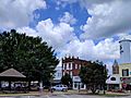
A view of historic downtown Troy
-
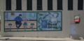
A Norman Rockwell painting on the side of Byrd Drugs in downtown Troy
-
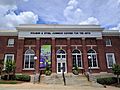
The Johnson Center for the Arts
-
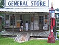
The old Adams General Store at the Pioneer Museum
-
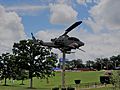
A Bell AH-1 SuperCobra in Bicentennial Park
-
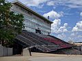
A view of Veterans Memorial Stadium


See also
 In Spanish: Troy (Alabama) para niños
