Conecuh River facts for kids
Quick facts for kids Conecuh River |
|
|---|---|
 |
|
| Country | United States |
| Location | Pensacola, Florida, Brewton, Alabama, East Brewton, Alabama, Pollard, Alabama, Flomaton, Alabama, Riverview, Alabama |
| Physical characteristics | |
| Main source | 32°08′14″N 85°40′43″W / 32.1371°N 85.6786°W |
| River mouth | Gulf of Mexico 30°59′48″N 87°10′33″W / 30.9966°N 87.1758°W |
| Length | 258 miles (415 km) |
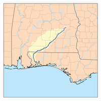
The Conecuh River and Escambia River are actually two names for the same river! This long river stretches about 258-mile (415 km) through the states of Alabama and Florida in the United States. It's an important waterway for the areas it flows through.
The River's Journey
The Conecuh River begins its journey near a place called Union Springs in Alabama. From there, it flows for about 198 miles (319 km) generally towards the southwest. It continues its path until it reaches Florida, near the town of Century.
A Name Change
When the river crosses into Florida, something interesting happens: its name changes! Just about 1.2 miles (1.9 km) downstream from the Alabama-Florida border, the river meets a smaller stream called Escambia Creek. After this meeting point, the river is no longer called the Conecuh River. Instead, it becomes known as the Escambia River.
Flowing to the Gulf
Once it becomes the Escambia River, it flows for another 60 miles (97 km) south. Its final destination is Escambia Bay, which is a part of Pensacola Bay. Pensacola Bay then opens up into the vast Gulf of Mexico. So, the water that started in Alabama eventually makes its way to the ocean!
River Maintenance
To help boats and ships travel more easily, the lower part of the river is sometimes made deeper. This process helps keep the river clear for different activities.
 | Aaron Henry |
 | T. R. M. Howard |
 | Jesse Jackson |


