Flomaton, Alabama facts for kids
Quick facts for kids
Flomaton, Alabama
|
|
|---|---|
 |
|

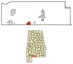
Location in Escambia County and Alabama
|
|
| Country | United States |
| State | Alabama |
| County | Escambia |
| Area | |
| • Total | 5.20 sq mi (13.46 km2) |
| • Land | 5.08 sq mi (13.17 km2) |
| • Water | 0.11 sq mi (0.29 km2) |
| Elevation | 62 ft (19 m) |
| Population
(2020)
|
|
| • Total | 1,466 |
| • Density | 288.30/sq mi (111.31/km2) |
| Time zone | UTC-6 (Central (CST)) |
| • Summer (DST) | UTC-5 (CDT) |
| ZIP code |
36441
|
| Area code(s) | 251 |
| FIPS code | 01-26824 |
| GNIS feature ID | 0157953 |
| Website | https://www.flomatonal.org/index.html |
Flomaton is a small town in Escambia County, Alabama, United States. It is located right next to the border between Alabama and Florida. In 2020, about 1,466 people lived there.
Contents
History of Flomaton
Flomaton became an official town in 1908. It started as a settlement around a railway junction in 1869. This junction was a meeting point for different train lines of the Louisville & Nashville Railroad. These train lines connected Flomaton to big cities like New York City, Cincinnati, Atlanta, and New Orleans. Trains also went south to the beach city of Pensacola, Florida.
The town's name, "Flomaton," is a mix of "Florida," "Alabama," and "town." This name shows its special location right on the border of the two states. In the early 1900s, Flomaton's economy was mainly based on the timber industry (cutting down trees for wood) and its important railway connections.
Geography and Location
Flomaton is located at 31°0′32″N 87°15′21″W / 31.00889°N 87.25583°W. It sits on the northern side of the border between Alabama and Florida. Just across the border, in Florida, is the town of Century.
Two major roads, U.S. Route 29 and U.S. Route 31, meet in Flomaton. U.S. Route 29 comes from Pensacola, Florida, about 45 miles (72 km) south. U.S. Route 31 comes from the west, starting near Mobile. These two highways travel together for about 14 miles (23 km) before they separate in Brewton.
The town is also an important railway junction. It connects CSX Transportation's train line from Montgomery to Mobile with its line going south to Pensacola and Florida's Gulf Coast. The town covers about 5.3 square miles (13.7 km2) of land.
Population Facts
| Historical population | |||
|---|---|---|---|
| Census | Pop. | %± | |
| 1910 | 559 | — | |
| 1920 | 724 | 29.5% | |
| 1930 | 915 | 26.4% | |
| 1940 | 837 | −8.5% | |
| 1950 | 1,036 | 23.8% | |
| 1960 | 1,454 | 40.3% | |
| 1970 | 1,584 | 8.9% | |
| 1980 | 1,882 | 18.8% | |
| 1990 | 1,811 | −3.8% | |
| 2000 | 1,588 | −12.3% | |
| 2010 | 1,440 | −9.3% | |
| 2020 | 1,466 | 1.8% | |
| U.S. Decennial Census 2013 Estimate |
|||
2020 Census
In the 2020 United States census, Flomaton had 1,466 people. There were 608 households and 416 families living in the town.
Here's a look at the different groups of people living in Flomaton in 2020:
| Race | Number of People | Percentage |
|---|---|---|
| White (not Hispanic) | 953 | 65.01% |
| Black or African American (not Hispanic) | 378 | 25.78% |
| Native American | 20 | 1.36% |
| Other/Mixed | 77 | 5.25% |
| Hispanic or Latino | 38 | 2.59% |
2010 Census
The 2010 census counted 1,440 people in Flomaton. This was a decrease from the 1,588 people counted in the year 2000.
In 2010, the town had 593 households. About 31.7% of these households had children under 18 living with them. The population density was about 271.6 people per square mile (104.9 per km2).
The racial makeup of the town in 2010 was:
- 69.5% White
- 27.2% Black or African American
- 1.6% Native American
- 1.32% from two or more races
- 2.3% of the population were Hispanic or Latino of any race.
The average age of people in Flomaton in 2010 was 37.4 years old. There were 670 males and 770 females.
Education
The schools in Flomaton are part of the Escambia County Public School System.
Notable People
- Sidney E. Manning — A soldier from World War I who received the Medal of Honor for his bravery.
See also
 In Spanish: Flomaton para niños
 | Roy Wilkins |
 | John Lewis |
 | Linda Carol Brown |

