
Union Springs, Alabama facts for kids
Quick facts for kids
Union Springs
|
||
|---|---|---|
|
City
|
||

Union Springs at sundown
|
||
|
||
| Nickname(s):
Bird Dog Field Trial Capital of the World;
The Serendipity Center of the South |
||

Location of Union Springs in Bullock County, Alabama.
|
||
| Country | United States | |
| State | Alabama | |
| County | Bullock | |
| Settled | 1835 | |
| Incorporated | 1844 | |
| Government | ||
| • Type | Mayor/Council | |
| Area | ||
| • Total | 6.69 sq mi (17.33 km2) | |
| • Land | 6.63 sq mi (17.17 km2) | |
| • Water | 0.06 sq mi (0.15 km2) | |
| Elevation | 522 ft (159 m) | |
| Population
(2020)
|
||
| • Total | 3,358 | |
| • Density | 506.49/sq mi (195.56/km2) | |
| Time zone | UTC-6 (Central (CST)) | |
| • Summer (DST) | UTC-5 (CDT) | |
| ZIP code |
36089
|
|
| Area code | 334 | |
| FIPS code | 01-77880 | |
| GNIS feature ID | 0128349 | |

Union Springs is a city in Bullock County, Alabama, USA. It is also the county seat, which means it's where the local government offices are located. In 2020, about 3,358 people lived here.
Union Springs is known as the "Bird Dog Field Trial Capital of the World." It's also called "The Serendipity Center of the South."
Contents
History of Union Springs
How Union Springs Began
The area where Union Springs is located was first settled by white people in the 1830s. This happened after the Creek Native Americans were moved from their lands.
The city got its name from the 27 natural springs that watered the land. These springs were a very important water source.
Becoming a City and County Seat
Union Springs officially became a city on January 13, 1844. Later, in 1866, when Bullock County was formed, people voted for Union Springs to be its county seat.
Geography and Location
Where is Union Springs Located?
Union Springs is in southeastern Alabama. It's right in the middle of Bullock County. Its exact location is 32°8'24.407" North and 85°42'46.094" West.
The Conecuh River actually starts within the city limits of Union Springs.

Major Roads and Size
The city is located where two main roads meet: U.S. Route 82 and U.S. Route 29.
- Route 82 goes east about 40 miles to Eufaula. It also goes northwest about 46 miles to Montgomery, which is Alabama's capital city.
- Route 29 goes north about 23 miles to Tuskegee. It also goes southwest about 40 miles to Troy.
Union Springs covers a total area of about 6.69 square miles (17.3 square kilometers). Most of this area is land, with a small part being water.
Climate
Weather in Union Springs
The climate in Union Springs has hot, humid summers. The winters are usually mild to cool. This type of weather is called a humid subtropical climate. On climate maps, it's shown as "Cfa."
| Climate data for Union Springs, Alabama, 1991–2020 normals, extremes 1892–2016 | |||||||||||||
|---|---|---|---|---|---|---|---|---|---|---|---|---|---|
| Month | Jan | Feb | Mar | Apr | May | Jun | Jul | Aug | Sep | Oct | Nov | Dec | Year |
| Record high °F (°C) | 82 (28) |
84 (29) |
92 (33) |
96 (36) |
102 (39) |
106 (41) |
107 (42) |
104 (40) |
106 (41) |
98 (37) |
89 (32) |
83 (28) |
107 (42) |
| Mean maximum °F (°C) | 74.1 (23.4) |
77.2 (25.1) |
83.1 (28.4) |
86.3 (30.2) |
90.3 (32.4) |
94.7 (34.8) |
96.0 (35.6) |
96.0 (35.6) |
92.6 (33.7) |
87.6 (30.9) |
81.3 (27.4) |
76.4 (24.7) |
97.6 (36.4) |
| Mean daily maximum °F (°C) | 58.0 (14.4) |
61.9 (16.6) |
69.2 (20.7) |
75.3 (24.1) |
81.9 (27.7) |
87.1 (30.6) |
89.4 (31.9) |
88.5 (31.4) |
85.1 (29.5) |
76.7 (24.8) |
67.2 (19.6) |
59.7 (15.4) |
75.0 (23.9) |
| Daily mean °F (°C) | 46.3 (7.9) |
49.7 (9.8) |
56.1 (13.4) |
62.0 (16.7) |
69.9 (21.1) |
76.7 (24.8) |
79.7 (26.5) |
78.9 (26.1) |
74.6 (23.7) |
64.2 (17.9) |
53.8 (12.1) |
48.4 (9.1) |
63.4 (17.4) |
| Mean daily minimum °F (°C) | 34.5 (1.4) |
37.5 (3.1) |
43.0 (6.1) |
48.8 (9.3) |
57.9 (14.4) |
66.3 (19.1) |
70.0 (21.1) |
69.3 (20.7) |
64.1 (17.8) |
51.8 (11.0) |
40.5 (4.7) |
37.0 (2.8) |
51.7 (11.0) |
| Mean minimum °F (°C) | 17.3 (−8.2) |
20.9 (−6.2) |
26.6 (−3.0) |
33.3 (0.7) |
44.9 (7.2) |
56.3 (13.5) |
63.6 (17.6) |
62.0 (16.7) |
49.6 (9.8) |
34.7 (1.5) |
26.5 (−3.1) |
19.4 (−7.0) |
13.5 (−10.3) |
| Record low °F (°C) | −2 (−19) |
−7 (−22) |
14 (−10) |
28 (−2) |
36 (2) |
44 (7) |
55 (13) |
51 (11) |
39 (4) |
26 (−3) |
15 (−9) |
3 (−16) |
−7 (−22) |
| Average precipitation inches (mm) | 5.02 (128) |
4.72 (120) |
5.47 (139) |
4.57 (116) |
4.34 (110) |
4.91 (125) |
5.90 (150) |
5.00 (127) |
3.79 (96) |
3.41 (87) |
4.83 (123) |
5.23 (133) |
57.19 (1,454) |
| Average snowfall inches (cm) | 0.0 (0.0) |
0.2 (0.51) |
0.2 (0.51) |
0.0 (0.0) |
0.0 (0.0) |
0.0 (0.0) |
0.0 (0.0) |
0.0 (0.0) |
0.0 (0.0) |
0.0 (0.0) |
0.0 (0.0) |
0.2 (0.51) |
0.6 (1.53) |
| Average precipitation days (≥ 0.01 in) | 8.5 | 7.8 | 7.5 | 6.7 | 5.9 | 8.7 | 9.9 | 8.9 | 5.8 | 4.6 | 6.0 | 7.6 | 87.9 |
| Average snowy days (≥ 0.1 in) | 0.0 | 0.1 | 0.1 | 0.0 | 0.0 | 0.0 | 0.0 | 0.0 | 0.0 | 0.0 | 0.0 | 0.2 | 0.4 |
| Source 1: NOAA | |||||||||||||
| Source 2: XMACIS2 (mean maxima/minima 1981–2010) | |||||||||||||
Population of Union Springs
How Many People Live Here?
| Historical population | |||
|---|---|---|---|
| Census | Pop. | %± | |
| 1870 | 1,455 | — | |
| 1880 | 1,862 | 28.0% | |
| 1890 | 2,049 | 10.0% | |
| 1900 | 2,634 | 28.6% | |
| 1910 | 4,055 | 53.9% | |
| 1920 | 4,125 | 1.7% | |
| 1930 | 2,875 | −30.3% | |
| 1940 | 3,107 | 8.1% | |
| 1950 | 3,232 | 4.0% | |
| 1960 | 3,704 | 14.6% | |
| 1970 | 4,324 | 16.7% | |
| 1980 | 4,431 | 2.5% | |
| 1990 | 3,975 | −10.3% | |
| 2000 | 3,670 | −7.7% | |
| 2010 | 3,980 | 8.4% | |
| 2020 | 3,358 | −15.6% | |
| U.S. Decennial Census | |||
The population of Union Springs has changed over the years. In 2020, the city had 3,358 residents.
Who Lives in Union Springs?
| Race | Num. | Perc. |
|---|---|---|
| White (non-Hispanic) | 318 | 9.47% |
| Black or African American (non-Hispanic) | 2,548 | 75.88% |
| Asian | 5 | 0.15% |
| Pacific Islander | 2 | 0.06% |
| Other/Mixed | 73 | 2.17% |
| Hispanic or Latino | 412 | 12.27% |
The 2020 census showed that most people living in Union Springs are Black or African American. There are also White, Asian, Pacific Islander, and people of mixed races. About 12% of the population is Hispanic or Latino.
Education in Union Springs
Local Schools
The schools in Union Springs are part of the Bullock County School District.
- There are two high schools: Bullock County High School and Bullock County Career Technical Center.
- South Highlands Middle School is the middle school.
- Union Springs Elementary is the elementary school.
There is also a private school called Conecuh Springs Christian School. It teaches students from kindergarten through 12th grade.
Media and News
Local Information Sources
- Newspaper: The local newspaper is the Union Springs Herald.
- Radio: You can listen to WQSI 93.9 FM for modern rock music.
City Services and Facilities
Important Infrastructure
The United States Postal Service has a post office in Union Springs. This is where people send and receive mail.
The Alabama Department of Corrections runs the Bullock Correctional Facility. This prison is located just outside Union Springs in Bullock County.
Economy and Jobs
How the City Makes Money
In the past, Union Springs was a big cotton-growing area. After the Civil War, the arrival of the railroad helped the city's economy grow.
By the early 1900s, many old cotton farms became places for hunting. This brought tourists to the area. Today, Union Springs is still an important business center for the farms around it.
A big employer in the city is Bonnie Plants, Inc.. This company sells plants and was started in 1918. It makes a lot of money each year.
Fun Things to Do
Recreation and Culture
Union Springs is famous for its yearly field trials. These events are for hunting dogs. They happen between October and March. People from all over the country come to watch and take part.
Famous People from Union Springs
Many notable people have connections to Union Springs:
- Henry Babers – A Christian speaker and Bible teacher.
- Winton M. Blount – He was the United States Postmaster General from 1969 to 1972.
- John Warren Branscomb – A bishop in the United Methodist Church.
- Edith Burroughs – The first African American woman to win a professional bowling tournament in the USA.
- Helen Claire – A Broadway actress.
- John Henrik Clarke – A writer and professor who studied African history.
- Fate Echols – An NFL football player.
- Lucy Feagin – The first woman to run a drama school in New York City.
- Seal Harris – A former heavyweight boxer.
- Jimmy Hitchcock – The first All-American football player at Auburn University.
- Eddie Kendricks – A co-founder of the famous music group The Temptations.
- Thom S. Rainer – The President and CEO of LifeWay Christian Resources.
- Tim Stowers – A college football coach.
- Mary Hardway Walker – One of the last people who had been enslaved in the United States.
Gallery
-
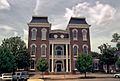
The Bullock County Courthouse in Union Springs is listed on the National Register of Historic Places.
-
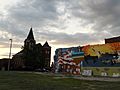
Union Springs at sundown
-
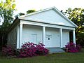
Sardis Baptist Church, located just outside Union Springs, was added to the National Register of Historic Places on November 29, 2001.
-
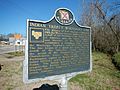
A historical marker near Union Springs shows the Indian Territory boundary line created by the Treaty of Fort Jackson.
-
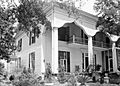
Foster House is listed on the National Register of Historic Places.
-
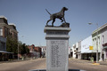
Bird dog monument, Life-size bronze statue of an English pointer


.jpg)
See also
 In Spanish: Union Springs (Alabama) para niños
