
Clayton, Alabama facts for kids
Quick facts for kids
Clayton City Alabama
|
||
|---|---|---|

Courthouse Square and Confederate Monument in Clayton
|
||
|
||

Location of Clayton in Barbour County, Alabama.
|
||
| Country | United States | |
| State | Alabama | |
| County | Barbour | |
| Area | ||
| • Total | 6.78 sq mi (17.55 km2) | |
| • Land | 6.78 sq mi (17.55 km2) | |
| • Water | 0.00 sq mi (0.00 km2) | |
| Elevation | 591 ft (180 m) | |
| Population
(2020)
|
||
| • Total | 2,265 | |
| • Density | 334.27/sq mi (129.06/km2) | |
| Time zone | UTC-6 (Central (CST)) | |
| • Summer (DST) | UTC-5 (CDT) | |
| ZIP code |
36016
|
|
| Area code(s) | 334 | |
| FIPS code | 01-15376 | |
| GNIS feature ID | 0116206 | |

Clayton is a town in Alabama, United States. It is the main town, or county seat, of Barbour County. In 2020, about 2,265 people lived there. This was a change from 3,008 people in 2010.
Contents
History of Clayton
Clayton became the county seat in 1834. This was just two years after Barbour County was created. The town is located in the middle of the county. It was built near the beginnings of the Pea and Choctawhatchee rivers. It was also on an old road that connected Hobdy's Bridge to Eufaula.
People started settling in the area around 1823. The town was named after Augustin S. Clayton. He was a judge and politician from Georgia. Clayton was officially laid out with a central courthouse square. The first court meeting happened there on September 23, 1833.
The Clayton post office opened in September 1835. John F. Keener was its first postmaster. On December 21, 1841, the Alabama Legislature officially made Clayton a town. At that time, about 200 people lived there. John Jackson became its first mayor after it was incorporated.
Clayton has a rich history. Four of its buildings are listed on the National Register of Historic Places. The town is also known for its unique Whiskey Bottle Tombstone. This was even shown in Ripley's Believe It or Not!.
Governor George Wallace was born nearby in Clio. He started his law and political career in Clayton. In March 1956, Governor Wallace attended a large public meeting at the Clayton football stadium. This meeting discussed important civil rights issues of the time. About 4,500 people attended, making it a very big event for the county.
Geography
Clayton is located at 31°52'39.014" North and 85°26'56.486" West.
The U.S. Census Bureau says the town covers about 17.3 square kilometers (6.7 square miles). All of this area is land.
Climate
The weather in Clayton has hot, humid summers. Winters are usually mild to cool. According to the Köppen Climate Classification system, Clayton has a humid subtropical climate. This means it has warm temperatures and plenty of rain throughout the year.
| Climate data for Clayton, Alabama, 1991–2020 normals, extremes 1956–present | |||||||||||||
|---|---|---|---|---|---|---|---|---|---|---|---|---|---|
| Month | Jan | Feb | Mar | Apr | May | Jun | Jul | Aug | Sep | Oct | Nov | Dec | Year |
| Record high °F (°C) | 82 (28) |
84 (29) |
88 (31) |
94 (34) |
98 (37) |
102 (39) |
104 (40) |
105 (41) |
102 (39) |
99 (37) |
92 (33) |
84 (29) |
105 (41) |
| Mean maximum °F (°C) | 74.0 (23.3) |
77.6 (25.3) |
83.0 (28.3) |
86.2 (30.1) |
92.7 (33.7) |
95.4 (35.2) |
97.3 (36.3) |
97.0 (36.1) |
94.3 (34.6) |
88.3 (31.3) |
81.9 (27.7) |
75.8 (24.3) |
98.3 (36.8) |
| Mean daily maximum °F (°C) | 58.3 (14.6) |
62.5 (16.9) |
69.8 (21.0) |
76.5 (24.7) |
84.0 (28.9) |
88.8 (31.6) |
91.3 (32.9) |
90.4 (32.4) |
86.1 (30.1) |
77.9 (25.5) |
68.3 (20.2) |
60.3 (15.7) |
76.2 (24.5) |
| Daily mean °F (°C) | 47.7 (8.7) |
51.3 (10.7) |
57.9 (14.4) |
64.4 (18.0) |
72.4 (22.4) |
78.8 (26.0) |
81.3 (27.4) |
80.7 (27.1) |
76.1 (24.5) |
66.7 (19.3) |
56.5 (13.6) |
50.1 (10.1) |
65.3 (18.5) |
| Mean daily minimum °F (°C) | 37.0 (2.8) |
40.1 (4.5) |
46.0 (7.8) |
52.4 (11.3) |
60.9 (16.1) |
68.8 (20.4) |
71.4 (21.9) |
71.1 (21.7) |
66.1 (18.9) |
55.4 (13.0) |
44.6 (7.0) |
39.8 (4.3) |
54.5 (12.5) |
| Mean minimum °F (°C) | 18.6 (−7.4) |
23.4 (−4.8) |
27.7 (−2.4) |
36.6 (2.6) |
44.9 (7.2) |
59.0 (15.0) |
65.2 (18.4) |
62.7 (17.1) |
52.5 (11.4) |
37.7 (3.2) |
27.2 (−2.7) |
23.5 (−4.7) |
16.7 (−8.5) |
| Record low °F (°C) | −6 (−21) |
11 (−12) |
13 (−11) |
27 (−3) |
32 (0) |
48 (9) |
57 (14) |
56 (13) |
42 (6) |
28 (−2) |
17 (−8) |
−5 (−21) |
−6 (−21) |
| Average precipitation inches (mm) | 4.55 (116) |
5.23 (133) |
5.21 (132) |
4.98 (126) |
3.70 (94) |
4.94 (125) |
6.03 (153) |
4.54 (115) |
3.68 (93) |
3.33 (85) |
3.83 (97) |
5.62 (143) |
55.64 (1,412) |
| Average snowfall inches (cm) | 0.2 (0.51) |
0.0 (0.0) |
0.0 (0.0) |
0.0 (0.0) |
0.0 (0.0) |
0.0 (0.0) |
0.0 (0.0) |
0.0 (0.0) |
0.0 (0.0) |
0.0 (0.0) |
0.0 (0.0) |
0.3 (0.76) |
0.5 (1.27) |
| Average precipitation days (≥ 0.01 in) | 7.8 | 8.4 | 7.2 | 6.5 | 5.9 | 9.9 | 10.0 | 9.0 | 6.2 | 4.3 | 5.4 | 7.8 | 88.4 |
| Average snowy days (≥ 0.1 in) | 0.4 | 0.1 | 0.0 | 0.0 | 0.0 | 0.0 | 0.0 | 0.0 | 0.0 | 0.0 | 0.0 | 0.1 | 0.6 |
| Source 1: NOAA | |||||||||||||
| Source 2: National Weather Service | |||||||||||||
Population Data
| Historical population | |||
|---|---|---|---|
| Census | Pop. | %± | |
| 1850 | 400 | — | |
| 1880 | 761 | — | |
| 1890 | 997 | 31.0% | |
| 1900 | 998 | 0.1% | |
| 1910 | 1,130 | 13.2% | |
| 1920 | 989 | −12.5% | |
| 1930 | 1,717 | 73.6% | |
| 1940 | 1,813 | 5.6% | |
| 1950 | 1,583 | −12.7% | |
| 1960 | 1,313 | −17.1% | |
| 1970 | 1,626 | 23.8% | |
| 1980 | 1,589 | −2.3% | |
| 1990 | 1,564 | −1.6% | |
| 2000 | 1,475 | −5.7% | |
| 2010 | 3,008 | 103.9% | |
| 2020 | 2,265 | −24.7% | |
| U.S. Decennial Census 2013 Estimate |
|||
2020 Census Information
| Race | Number | Percent |
|---|---|---|
| White (not Hispanic) | 779 | 34.39% |
| Black or African American (not Hispanic) | 1,413 | 62.38% |
| Asian | 2 | 0.09% |
| Other/Mixed | 35 | 1.55% |
| Hispanic or Latino | 36 | 1.59% |
In 2020, the town had 2,265 people. There were 569 households and 359 families living there.
2010 Census Information
In 2010, Clayton had 3,008 people. There were 552 households and 349 families. The town had about 450 people per square mile. There were 649 homes.
The people living in Clayton were mostly Black or African American (63.8%). White people made up 35.8% of the population. A small number of people were from other racial groups. About 0.6% of the population was Hispanic or Latino.
In terms of households, 28.8% had children under 18. About 31.2% were married couples. Another 27.7% were households led by a woman without a husband. About 36.8% were not families. Many households (33.5%) had only one person living there. About 13.1% had someone aged 65 or older living alone. The average household had 2.33 people, and the average family had 2.95 people.
The population was spread out by age:
- 11.9% were under 18 years old.
- 11.7% were 18 to 24 years old.
- 46.1% were 25 to 44 years old.
- 23.3% were 45 to 64 years old.
- 7.1% were 65 years or older.
The average age was 34.8 years.
The average income for a household in Clayton was $23,629. For a family, it was $17,778. About 29.3% of all people, and 27.4% of families, lived below the poverty line. This included 30.6% of those under 18 and 26.3% of those 65 or older.
Education
Clayton is part of the Barbour County Schools system. Both Barbour County High School and Barbour County Primary School are located in the town.
Famous People from Clayton
Many notable people have connections to Clayton:
- Mildred Adair (1895–1943), a composer, pianist, and teacher.
- George W. Andrews, who served in the U.S. House of Representatives.
- Billy Beasley, an Alabama politician.
- Jere Beasley (born 1935), who was Lieutenant Governor of Alabama twice and also acting Governor.
- Thomas J. Clarke (Alabama politician), a farmer and state lawmaker in the late 1800s.
- Bertram Tracy Clayton (1862–1918), a U.S. House of Representatives member from New York and a U.S. Army officer who died in World War I.
- Henry DeLamar Clayton, Sr. (1827–1889), a major general in the Confederate army and former President of the University of Alabama.
- Henry De Lamar Clayton, Jr. (1857–1929), who served in the U.S. House of Representatives and wrote the important Clayton Antitrust Act.
- Travis Grant (born 1950), a college and professional basketball player.
- Clarence Clement "Shovel" Hodge (1893–1967), a Major League Baseball pitcher.
- Katherine Jackson, the mother of the famous Jackson family of musicians.
- McDowell Lee, a member of the Alabama House of Representatives.
- Albert J. Lingo, who directed the Alabama Department of Public Safety from 1963 to 1965.
- Ann Lowe (1899–1981), a designer who created the wedding dress for Jacqueline Bouvier Kennedy Onassis when she married John F. Kennedy.
- George Wallace (1919–1998), a well-known Governor of Alabama and a candidate for U.S. president.
- George C. Wallace, Jr. (born 1951), who was the Alabama State Treasurer.
- Lurleen Wallace (1926–1968), also a Governor of Alabama.
- Ariosto A. Wiley, a U.S. Representative from 1901 to 1908.
Gallery
-
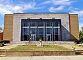
The Barbour County Courthouse is located in Clayton.
-
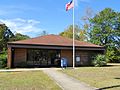
The post office in Clayton (ZIP code: 36016)
-
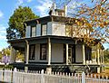
The Petty-Roberts-Beatty House is an octagon house built in 1861. It is one of only two antebellum octagonal houses built in Alabama and the only one to survive. It was added to the National Register of Historic Places on January 21, 1974.
-
The Miller-Martin Town House was built in 1859. This Gothic Revival townhouse is known for its hand-painted murals on the entrance hall ceiling. These murals show the four seasons. It was added to the National Register of Historic Places on December 16, 1974.
-
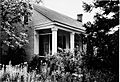
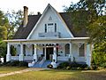
The Henry D. Clayton House was built around 1850. It was the home of Confederate General Henry D. Clayton, Sr., who was also a former President of the University of Alabama. His son, Henry D. Clayton, Jr., a legislator and judge, also lived here. This house was added to the National Register of Historic Places on December 8, 1976.
-
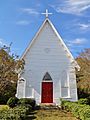
The Grace Episcopal Church is a Gothic Revival-style building. It was finished on February 26, 1876. It was added to the National Register of Historic Places on September 22, 1995.


See also
 In Spanish: Clayton (Alabama) para niños
