Jefferson County, Mississippi facts for kids
Quick facts for kids
Jefferson County
|
|
|---|---|

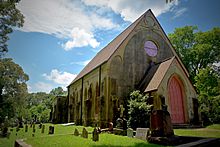
Historic Christ Church, Church Hill, Mississippi.
|
|

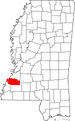
Location within the U.S. state of Mississippi
|
|
 Mississippi's location within the U.S. |
|
| Country | |
| State | |
| Founded | 1799 |
| Named for | Thomas Jefferson |
| Seat | Fayette |
| Largest city | Fayette |
| Area | |
| • Total | 527 sq mi (1,360 km2) |
| • Land | 520 sq mi (1,300 km2) |
| • Water | 7.3 sq mi (19 km2) 1.4% |
| Population
(2020)
|
|
| • Total | 7,260 |
| • Estimate
(2023)
|
6,941 |
| • Density | 13.776/sq mi (5.319/km2) |
| Time zone | UTC−6 (Central) |
| • Summer (DST) | UTC−5 (CDT) |
| Congressional district | 2nd |
Jefferson County is a place in the state of Mississippi, USA. It's called a county, and its western edge touches the famous Mississippi River.
In 2020, about 7,260 people lived here. This makes it one of the counties in Mississippi with the fewest people. The county seat, which is like its main town, is Fayette. Before 1825, the county seat was in a place called Old Greenville, which doesn't exist anymore.
Jefferson County is named after Thomas Jefferson, who was an early U.S. President. It was one of the very first counties created in the Mississippi Territory back in 1798. At first, it was called Pickering County.
Long ago, this area was known for its large cotton farms. But over time, farming changed, and many people moved to cities. Because of this, the county's population has become much smaller. For example, in 1900, there were three times as many people living here as there are today.
Contents
Exploring Jefferson County's Geography
Jefferson County covers a total area of about 527 square miles. Most of this area, about 520 square miles, is land. The rest, about 7.3 square miles, is water.
Main Roads in Jefferson County
These are the most important roads that go through the county:
Neighboring Counties and Parishes
Jefferson County shares borders with these other counties and a parish:
- To the north: Claiborne County
- To the northeast: Copiah County
- To the southeast: Lincoln County
- To the south: Franklin County
- To the southwest: Adams County
- To the west: Tensas Parish, Louisiana (a parish is like a county in Louisiana)
Special Protected Areas
Parts of these important natural areas are found in Jefferson County:
- Homochitto National Forest
- Natchez Trace Parkway
Who Lives in Jefferson County?
| Historical population | |||
|---|---|---|---|
| Census | Pop. | %± | |
| 1800 | 2,940 | — | |
| 1810 | 4,001 | 36.1% | |
| 1820 | 6,822 | 70.5% | |
| 1830 | 9,755 | 43.0% | |
| 1840 | 11,650 | 19.4% | |
| 1850 | 13,193 | 13.2% | |
| 1860 | 15,349 | 16.3% | |
| 1870 | 13,848 | −9.8% | |
| 1880 | 17,314 | 25.0% | |
| 1890 | 18,947 | 9.4% | |
| 1900 | 21,292 | 12.4% | |
| 1910 | 18,221 | −14.4% | |
| 1920 | 15,946 | −12.5% | |
| 1930 | 14,291 | −10.4% | |
| 1940 | 13,969 | −2.3% | |
| 1950 | 11,306 | −19.1% | |
| 1960 | 10,142 | −10.3% | |
| 1970 | 9,295 | −8.4% | |
| 1980 | 9,181 | −1.2% | |
| 1990 | 8,653 | −5.8% | |
| 2000 | 9,740 | 12.6% | |
| 2010 | 7,726 | −20.7% | |
| 2020 | 7,260 | −6.0% | |
| 2023 (est.) | 6,941 | −10.2% | |
| U.S. Decennial Census 1790-1960 1900-1990 1990-2000 2010-2013 |
|||
In 2020, there were 7,260 people living in Jefferson County. These people lived in about 2,448 homes, and 1,488 of these were families.
Here's a look at the different groups of people living in Jefferson County in 2020:
| Race | Number of People | Percentage |
|---|---|---|
| White | 891 | 12.27% |
| Black or African American | 6,138 | 84.55% |
| Native American | 10 | 0.14% |
| Asian | 14 | 0.19% |
| Pacific Islander | 5 | 0.07% |
| Other/Mixed | 128 | 1.76% |
| Hispanic or Latino | 74 | 1.02% |
Learning in Jefferson County
The Jefferson County School District is in charge of the public schools here. Students in the county also attend Copiah–Lincoln Community College, which is a college for students after high school.
Places in Jefferson County
Here are some of the towns and communities you can find in Jefferson County:
City
- Fayette (This is the main town, also called the county seat.)
Small Communities (Unincorporated)
These are smaller places that don't have their own city government:
- Cannonsburg
- Church Hill
- Harriston
- Lorman
- McBride
- Red Lick
- Union Church
Old Towns (Ghost or Defunct)
These are places that used to be towns but are not active communities anymore:
- Ashland (or Ashland Landing)
- Cane Ridge
- Coon Box
- Gum Ridge
- Old Greenville
- Rodney
- Shankstown
- Uniontown
Famous People from Jefferson County
Some notable people have connections to Jefferson County:
- Abijah Hunt: He was a merchant who lived in Old Greenville a long time ago. He owned many stores and places where cotton was processed along the Natchez Trace.
- David Hunt: He was a wealthy farmer who lived on a large farm called Woodlawn Plantation. He was one of the richest farmers in the area before the American Civil War.
- Zachary Taylor: He was a U.S. President and a soldier. He often stayed at his farm, Cypress Grove, in Jefferson County between 1840 and 1848.
See also
 In Spanish: Condado de Jefferson (Misisipi) para niños
 | Stephanie Wilson |
 | Charles Bolden |
 | Ronald McNair |
 | Frederick D. Gregory |

