Franklin County, Mississippi facts for kids
Quick facts for kids
Franklin County
|
|
|---|---|

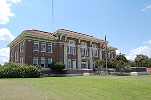
Franklin County Courthouse, Meadville, Mississippi.
|
|

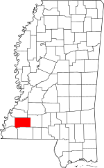
Location within the U.S. state of Mississippi
|
|
 Mississippi's location within the U.S. |
|
| Country | |
| State | |
| Founded | 1809 |
| Named for | Benjamin Franklin |
| Seat | Meadville |
| Largest town | Bude |
| Area | |
| • Total | 567 sq mi (1,470 km2) |
| • Land | 564 sq mi (1,460 km2) |
| • Water | 3.0 sq mi (8 km2) 0.5% |
| Population
(2020)
|
|
| • Total | 7,675 |
| • Estimate
(2023)
|
7,610 |
| • Density | 13.536/sq mi (5.226/km2) |
| Time zone | UTC−6 (Central) |
| • Summer (DST) | UTC−5 (CDT) |
| Congressional district | 3rd |
Franklin County is a county in the U.S. state of Mississippi. In 2020, about 7,675 people lived here. Its main town, or county seat, is Meadville. The county was created on December 21, 1809. It was named after Founding Father Benjamin Franklin. The Homochitto River flows through the county from one corner to the other.
Contents
History of Franklin County
Franklin County was the fourth county formed in Mississippi. It was first used for farming, especially for growing cotton. This work was done by enslaved African Americans. Cotton farming remained very important for the county's economy for many years.
This county is still mostly rural. Its population has dropped by about half since 1910. It is now the fourth least populated county in Mississippi. New farming machines and a pest called the boll weevil meant fewer farm workers were needed. Many people left the area and even the state. A lot of African Americans moved north or west during the Great Migration. This happened before and after World War II. Today, most people in the county are white. In 2000, over 36% of the population was African American.
Like other parts of Mississippi, Franklin County had Jim Crow laws. These laws kept people of different races separate in public places. Many white residents did not support the civil rights movement in the mid-1900s. In May 1964, two young Black men, Henry Hezekiah Dee and Charles Eddie Moore, were taken and killed. This happened before the Freedom Summer project began. Their bodies were found in the Mississippi River in July 1964. This was during the search for three missing civil rights workers.
No one was charged at the time. But the case was reopened in 2007 after a TV show about it. A local man, James Ford Seale, was later found guilty of the kidnappings and deaths. In 2008, the families of Dee and Moore sued the Franklin County government. They said that local law enforcement had been involved in the deaths. In 2010, Franklin County agreed to a private agreement with the families.
Geography and Natural Features
Franklin County covers about 567 square miles. Most of this area, about 564 square miles, is land. The rest, about 3 square miles, is water.
Main Roads in Franklin County
Neighboring Counties
- Jefferson County (north)
- Lincoln County (east)
- Amite County (south)
- Wilkinson County (southwest)
- Adams County (west)
Protected Natural Areas
- Homochitto National Forest (part of it is in Franklin County)
Towns and Communities
Towns in Franklin County
Other Communities
These places are not officially towns:
- Eddiceton
- Hamburg
- Knoxville
- Little Springs
- Lucien
- McCall Creek
- Quentin
- Veto
Population and People
| Historical population | |||
|---|---|---|---|
| Census | Pop. | %± | |
| 1810 | 2,016 | — | |
| 1820 | 3,821 | 89.5% | |
| 1830 | 4,622 | 21.0% | |
| 1840 | 4,775 | 3.3% | |
| 1850 | 5,904 | 23.6% | |
| 1860 | 8,265 | 40.0% | |
| 1870 | 7,498 | −9.3% | |
| 1880 | 9,729 | 29.8% | |
| 1890 | 10,424 | 7.1% | |
| 1900 | 13,678 | 31.2% | |
| 1910 | 15,193 | 11.1% | |
| 1920 | 14,156 | −6.8% | |
| 1930 | 12,268 | −13.3% | |
| 1940 | 12,504 | 1.9% | |
| 1950 | 10,929 | −12.6% | |
| 1960 | 9,286 | −15.0% | |
| 1970 | 8,011 | −13.7% | |
| 1980 | 8,208 | 2.5% | |
| 1990 | 8,377 | 2.1% | |
| 2000 | 8,448 | 0.8% | |
| 2010 | 8,118 | −3.9% | |
| 2020 | 7,675 | −5.5% | |
| 2023 (est.) | 7,610 | −6.3% | |
| U.S. Decennial Census 1790-1960 1900-1990 1990-2000 2010-2013 |
|||
| Number | Percent | |
|---|---|---|
| White (not Hispanic) | 4,910 | 63.97% |
| Black or African American (not Hispanic) | 2,563 | 33.39% |
| Native American | 2 | 0.03% |
| Asian | 8 | 0.1% |
| Other/Mixed | 132 | 1.72% |
| Hispanic or Latino | 60 | 0.78% |
In 2020, there were 7,675 people living in Franklin County. These people lived in 2,928 households, and 2,096 of these were families.
Education in Franklin County
Franklin County has one main school system. It is called the Franklin County School District.
The county is also part of the Copiah–Lincoln Community College district. It has been since 1948.
See also
 In Spanish: Condado de Franklin (Misisipi) para niños
 | Bessie Coleman |
 | Spann Watson |
 | Jill E. Brown |
 | Sherman W. White |

