Homochitto River facts for kids
Quick facts for kids Homochitto River |
|
|---|---|
| Country | United States |
| State | Mississippi |
| Physical characteristics | |
| Main source | 380 ft (120 m) 31°42′16″N 90°37′28″W / 31.70444°N 90.62444°W |
| River mouth | Mississippi River 33 ft (10 m) 31°12′53″N 91°31′41″W / 31.21472°N 91.52806°W |
| Length | 90 mi (140 km) |
| Basin features | |
| Basin size | 1,200 sq mi (3,100 km2) |
| Tributaries |
|
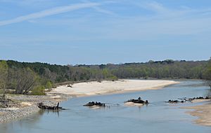
The Homochitto River is a river in the U.S. state of Mississippi. It flows for about 90 miles (140 km) from its start in southwest Mississippi. The river flows west and then south. It eventually empties into the mighty Mississippi River. This happens between the towns of Natchez and Woodville.
The name "Homochitto" comes from the Choctaw language. It probably means "big red."
Where Does the Homochitto River Flow?
The Homochitto River begins with several small streams. These streams are found near the border of Copiah County and Lincoln County. From there, it flows west and then south. It passes through the Homochitto National Forest.
After Lincoln County, the river enters Franklin County. It continues to flow south. Before a stream called McCall Creek joins it, two bridges cross the Homochitto. One is for U.S. Route 84, and the other is for the Illinois Central Railroad.
The river then turns southwest, flowing past the town of Bude. Further downstream, U.S. Route 98 crosses the river. The Middle Fork Homochitto River joins it from the north. A few miles later, the Homochitto River forms the border between Franklin and Amite counties. Here, it starts flowing more directly west.
Near the town of Rosetta, two more bridges cross the river. One is for Mississippi Highway 33, and the other is again for the Illinois Central Railroad. The river then flows through a wide, flat area called a floodplain. It used to have many curves, but parts of it have been straightened. On the north side, Franklin County changes to Adams County. Near the town of Doloroso, U.S. Route 61 crosses the Homochitto River.
Originally, the river flowed south and then west from Doloroso. It joined the Mississippi River at Lake Mary. Lake Mary is an oxbow lake, which is a U-shaped lake formed when a wide meander (bend) of a river is cut off. Today, most of the Homochitto's water flows west from Doloroso. It goes through the Abernathy Channel. This channel was built in 1938 by the United States Army Corps of Engineers. This new path lets the Homochitto River enter the Mississippi River several miles north of Lake Mary.
How People Changed the River

In 1938, the United States Army Corps of Engineers started changing the river. They built the Abernathy Channel. This was a shortcut from the Homochitto River near Doloroso to the Mississippi River. This shortcut made the river much shorter below Doloroso. It changed about 20 miles (32 km) of winding river into a straighter 9-mile (14 km) path. More shortcuts were built between Doloroso and Rosetta in 1940. These changes shortened the river by about 4 miles (6.4 km).
Other projects to control floods on the lower Homochitto were finished in 1952. These included cleaning the main river channel and digging out more shortcuts. All these projects aimed to stop floods along the lower Homochitto River. However, they had unexpected problems. The engineers at the time did not fully understand how rivers work.
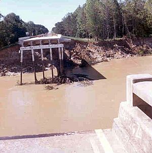
After these changes, the lower Homochitto River and some of its smaller streams started to wear away much faster. The shorter, straighter river made the water flow much faster. This increased erosion, which is when the river wears away its banks and bed. This also caused "scour," which is erosion around bridge foundations. This led to river banks collapsing and the river channel becoming unstable.
This faster erosion probably started near the Mississippi River in the early 1940s. It was noticed at Doloroso by 1944 and at Kingston by 1947. The river channel started eroding faster at Rosetta in the late 1940s.
This increased erosion caused several bridges to collapse. In 1955, a flood washed out the old U.S. Highway 61 bridge at Kingston. It also destroyed the Illinois Central Railroad bridge at Rosetta. A country road bridge on a stream called Second Creek was also washed out. In 1969, a bridge on Crooked Creek was destroyed. In 1971, the State Highway 33 bridge at Rosetta was washed out. During the big flood of 1974, both the State Highway 33 bridge and the Illinois Central bridge at Rosetta were washed away again.
 | Precious Adams |
 | Lauren Anderson |
 | Janet Collins |


