Buras-Triumph, Louisiana facts for kids
Quick facts for kids
Buras-Triumph
|
|
|---|---|
|
Former Census-designated place
|
|

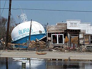
Fallen water tower following Hurricane Katrina
|
|
| Country | United States |
| State | Louisiana |
| Parish | Plaquemines |
| Area | |
| • Total | 7.2 sq mi (19 km2) |
| • Land | 5.0 sq mi (13 km2) |
| • Water | 2.2 sq mi (6 km2) |
| Elevation | 3 ft (0.9 m) |
| Population
(2000)
|
|
| • Total | 3,358 |
| • Density | 466/sq mi (180.1/km2) |
| Time zone | UTC-6 (CST) |
| • Summer (DST) | UTC-5 (CDT) |
| Area code(s) | 504 |
Buras-Triumph was a small community in Plaquemines Parish, Louisiana, United States. It was once listed as a "census-designated place," which is a special area defined by the government for counting people. In the year 2000, about 3,358 people lived there. Later, for the 2010 census, Buras-Triumph was divided into two separate areas: Buras and Triumph. Buras is located a bit higher up the peninsula, with Triumph to its southeast.
Contents
History of Buras-Triumph
The area that became Buras started to form in the 1840s. Several small groups of homes on the west side of the Mississippi River, north of Fort Jackson, became known as the "Quartiers des Burats." This name came from Sebastian Burat, who owned land there. Over time, "Burat" changed to "Buras." In 1854, a post office was opened, and mail started arriving regularly by boat. By 1864, the community had grown enough to build a new church called Our Lady of Good Harbor.
Buras During the Civil War
In April 1862, during the American Civil War, a big battle happened near Buras. It was called the Battle of Forts Jackson and St. Philip. A Union Navy leader, David Farragut, sailed his ships up the river to capture New Orleans. On April 23, his fleet fought against the forts. One Union ship, the USS Varuna, was sunk near Buras after fighting two Confederate ships, the CSS Governor Moore and the CSS Stonewall Jackson. The Governor Moore was also badly damaged and sank close to its Union opponent.
Life in the 20th Century
In the early 1900s, the main jobs in Buras were oyster fishing and growing citrus fruits like oranges. In the 1930s, oil, natural gas, and sulfur were found in the area. One of the first oil fields was set up by the Gulf Oil Company in Quarantine Bay, east of Buras. With these new industries, Buras slowly changed from a small farming and fishing village into a larger community.
Hurricanes and Their Impact
Buras-Triumph and the nearby communities have been hit by many powerful hurricanes over the years. Some of these include the 1893 Cheniere Caminada hurricane, which destroyed the first church, and storms in 1901 and 1915. Later, Hurricane Betsy hit in 1965, and Hurricane Camille in 1969.
More recently, on August 29, 2005, the center of Hurricane Katrina first reached land in Louisiana right in this area. Even though Katrina caused a lot of damage and was very costly, some older hurricanes like Betsy and Camille were actually stronger when they hit land. However, over time, the natural marshlands around Buras-Triumph had shrunk due to erosion. This meant that Katrina's powerful storm surge (a wall of ocean water pushed by the storm) could easily go over the levee system, causing huge floods and destruction.
A symbol of the community's recovery is the new Buras water tower. The old water tower, which collapsed during Katrina, became a famous image of the storm's destruction.
Geography of Buras-Triumph
Buras-Triumph is located on the west side of the Mississippi River. Its exact spot is 29°21′6″N 89°30′50″W / 29.35167°N 89.51389°W. The land there is very low, only about 3 feet (0.9 meters) above sea level. The community is protected by a system of levees designed to keep out floodwaters. About 3,000 acres (12 square kilometers) of the area are kept dry by two large pumping stations that remove stormwater.
The total area of Buras-Triumph was about 7.2 square miles (18.6 square kilometers). Most of this, about 5.0 square miles (12.9 square kilometers), was land. The rest, about 2.2 square miles (5.7 square kilometers), was water, making up about 30% of the total area.
People of Buras-Triumph
In 2000, there were 3,358 people living in Buras-Triumph. The community was made up of people from different backgrounds. About 71% were White, 10% were African American, 1% were Native American, and 12% were Asian. A small number of people were from other races or mixed races. About 1% of the population was Hispanic or Latino.
Many families lived in Buras-Triumph. About 40% of homes had children under 18. The average age of people living there was 32 years old.
Education in Buras-Triumph
The Plaquemines Parish School Board is in charge of the public schools in the area. Students from Buras-Triumph now attend South Plaquemines High School in Buras. Before 2005, there were separate schools called Buras Middle School and Buras High School. However, these school buildings were badly damaged by Hurricane Katrina, so new arrangements had to be made.
See also
 In Spanish: Buras (Luisiana) para niños
 | William M. Jackson |
 | Juan E. Gilbert |
 | Neil deGrasse Tyson |


