Storm history of Hurricane Katrina facts for kids
| Category 5 major hurricane (SSHWS/NWS) | |
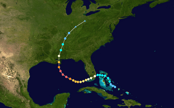
Hurricane Katrina track map
|
|
| Formed | August 23, 2005 |
|---|---|
| Dissipated | August 30, 2005 |
| Highest winds | 1-minute sustained: 175 mph (280 km/h) |
| Lowest pressure | 902 mbar (hPa); 26.64 inHg |
| Areas affected | Bahamas, South Florida, Cuba, Louisiana (especially Greater New Orleans), Mississippi, Alabama, Florida Panhandle, most of eastern North America |
| Part of the 2005 Atlantic hurricane season | |
| Hurricane Katrina |
|
 |
|
|
General Other wikis |
|
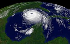
Hurricane Katrina was a very powerful storm that started on August 23, 2005. It was a highly destructive hurricane (a Category 5 storm on the Saffir-Simpson scale). Katrina began as a tropical depression (a weak storm) near the Bahamas. The next day, it became a tropical storm and was named Katrina.
Katrina then moved towards the southern part of Florida. It made landfall there as a Category 1 hurricane. After crossing Florida, Katrina weakened back into a tropical storm. But over the warm waters of the Gulf of Mexico, it quickly grew much stronger. It became the sixth strongest Atlantic hurricane ever recorded.
Later, Katrina made landfall again as a Category 3 hurricane near Buras-Triumph, Louisiana. It then hit land one more time near the Mississippi/Louisiana border. Katrina continued moving north through the central United States. It finally faded away near the Great Lakes, where it was absorbed by a cold front.
Contents
How Hurricane Katrina Formed
Tropical Depression Twelve started over the southeastern Bahamas at 5:00 p.m. EDT (9:00 p.m. UTC) on August 23, 2005. Part of this storm came from the leftover energy of Tropical Depression Ten. That earlier storm had weakened because of a nearby trough (a low-pressure area) in the upper troposphere (part of the atmosphere).
Usually, if a storm weakens and then gets stronger again, it keeps its old name. But satellite information showed that a new tropical wave (an area of low pressure) joined with the remains of Tropical Depression Ten. This created a new, stronger storm, which was then called Tropical Depression Twelve. At the same time, the trough weakened, which meant the wind shear (changes in wind speed or direction) in the area decreased. This helped the new tropical depression grow.
Later studies showed that the original Tropical Depression Ten had completely broken apart. Only its middle-level circulation moved on and combined with the second tropical wave. Because of this, it was considered a new storm and given a new name.
First Time Katrina Hit Land
The air around Tropical Depression Twelve was perfect for it to grow into a stronger storm. So, it began to get stronger. On the morning of August 24, it was upgraded to a Tropical Storm and given the name Katrina.
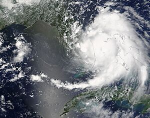
A burst of convection (rising warm air) helped Katrina become the fifth hurricane of the 2005 season on August 25. This happened just two hours before it made landfall around 6:30 p.m. EST (10:30 p.m. UTC). It hit land between Hallandale Beach and Aventura, Florida.
Katrina moved across Florida very fast with winds of 80 mph (130 km/h). It had a clear eye (the calm center of the storm) that stayed strong as it passed over Florida. On August 26, the storm weakened over land to a tropical storm. But it regained its hurricane strength at 2:00 a.m. EDT (6:00 a.m. UTC), about an hour after leaving Florida. Parts of the Florida Keys felt tropical storm-force winds throughout August 26. The Dry Tortugas even briefly had hurricane-force winds.
Katrina in the Gulf of Mexico
At first, weather experts thought Katrina would turn north after hitting Florida. They predicted it would hit the Florida Panhandle a few days later. However, Katrina kept moving west and southwest. This made forecasters change their predictions, now expecting Katrina to move towards New Orleans.
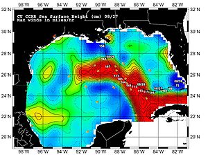
As soon as Katrina entered the Gulf of Mexico, it quickly became much stronger. This happened because of low wind shear, good air flow high up, and the very warm sea surface temperatures of the Gulf Loop Current. On August 27, Katrina was upgraded to a Category 3 hurricane. This made it the third major hurricane of the season.
For about 18 hours, an eyewall replacement cycle (where a new eyewall forms around the old one) stopped its winds from getting stronger. But this process almost doubled the size of the storm. Katrina then started to get much stronger again at 7:00 p.m. CDT on August 27. By 12:40 a.m. CDT on August 28, Katrina was a Category 4 hurricane with winds of 145 mph (233 km/h).
It became a Category 5 storm by 7:00 a.m. CDT. It reached its strongest point at 1:00 p.m. CDT with winds of 175 mph (280 km/h) and gusts up to 215 mph (344 km/h). Its central pressure was 902 mbar. This made Katrina, at that time, the fourth most intense Atlantic hurricane ever recorded. (Later that same year, Hurricanes Rita and Wilma would break Katrina's record.) As the hurricane got closer to New Orleans, the Weather Forecast Office in Slidell, Louisiana, sent out two very strong warnings about how dangerous the storm was.
By the afternoon of August 28, the storm was so large that some parts of the Gulf Coast were already feeling tropical storm-force winds. The center of Katrina was about 180 miles (290 km) from the mouth of the Mississippi River. But tropical storm-force winds reached 230 mi (370 km) from the center, and hurricane-force winds reached about 105 miles (170 km) away.
Overnight on August 29 and into the next morning, Katrina quickly weakened in terms of its strongest winds. This happened as it started another eyewall replacement cycle. The inner eyewall disappeared before a new outer eyewall fully formed, which helped it weaken fast. In 18 hours, the hurricane's strongest winds dropped from 170 mph (280 km/h) to 125 mph (205 km/h). However, the storm surge (a rise in sea level caused by the storm) stayed very high when it hit land. This was because huge waves, over 30 feet (9.1 m) tall, were created earlier when Katrina was a Category 4 and 5 storm. These waves then combined with the storm surge from the large Category 3 hurricane.
Second and Third Times Katrina Hit Land
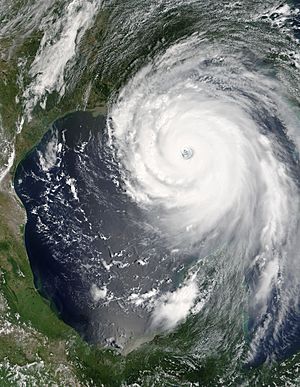
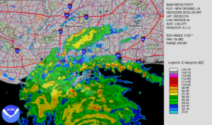
Katrina made its second landfall at 6:10 a.m. CDT on August 29. It was a Category 3 hurricane with winds of 125 mph (205 km/h) near Buras-Triumph, Louisiana. Because Katrina had just weakened from Category 4 strength, and because of the shape of the coastline, it's believed that Category 4-force winds still hit land even though the eye was over water. When it hit land, hurricane-force winds were recorded 120 miles (190 km) from the center. The storm's central pressure was 920 mbar, and it was moving at 15 mph (10 km/h).
As Katrina moved up the eastern Louisiana coastline, many towns in Plaquemines, St. Bernard Parish, and Slidell in St. Tammany Parish were badly damaged. This damage came from the storm surge and the strong winds of the eyewall. The eyewall also swept over eastern New Orleans, causing $1 billion worth of damage from severe flooding and wind.
At first, experts thought Katrina had made this landfall as a Category 4 hurricane with 135 mph (220 km/h) winds. However, as mentioned, the storm weakened just before hitting land to Category 3 strength. The reasons for this weakening are not fully understood. The eyewall replacement cycle played a part. Also, slightly increasing wind shear, dropping sea surface temperatures, dry air on the western side of the storm, and interacting with the land might have also helped weaken the hurricane. This is similar to other strong storms in the Gulf of Mexico: all storms with very low central pressures (973 mbar or less) have weakened in the 12 hours before hitting the Gulf Coast of the United States.
A few hours later, after weakening a bit more, Katrina made its third landfall near the Louisiana-Mississippi border. It still had 120 mph (195 km/h) winds and a pressure of 928 mbar, remaining a Category 3 storm. Its lowest pressure at its second landfall was 920 mbar. This made Katrina the third strongest hurricane ever to hit the United States. Only Hurricane Camille in 1969 (909 mbar) and the 1935 Labor Day Hurricane (892 mbar) were stronger.
Because the storm was so large, its very destructive eyewall winds and the strong northeastern part of the storm pushed record storm surges onto the shore. This smashed the entire Mississippi Gulf Coast, including towns like Waveland, Bay St. Louis, Pass Christian, Long Beach, Gulfport, Biloxi, Ocean Springs, Gautier, and Pascagoula. In Alabama, Bayou La Batre was also hit. The surges reached their highest at 28 feet (8.5 m) in Bay St. Louis, Mississippi. They were still 13 feet (4.0 m) as far away as Mobile, Alabama, which saw its highest storm surge since 1917. The storm surge was especially high because of the area's water features, the hurricane's huge size, and the fact that it only weakened a little bit before hitting land. As Katrina moved inland across Mississippi, its strong winds caused damage across almost the entire state.
How Hurricane Katrina Faded Away
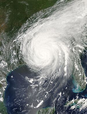
Katrina stayed at hurricane strength in Mississippi for a while, but it soon weakened. It lost its hurricane strength more than 150 miles (240 km) inland, near Meridian, Mississippi. Katrina then became a tropical depression near Clarksville, Tennessee, and split into two parts.
One part of the storm continued to move quickly northward, affecting the Central United States. It was last seen in the eastern Great Lakes region. On August 31, it was absorbed by a frontal boundary (where two air masses meet) and became a powerful extratropical cyclone (a type of low-pressure system). This caused 1.97–6.69 inches (50–170 mm) of rain in 12 hours. It also caused strong winds (31 to 61 mph or 50 to 98 km/h) in southeastern Quebec and northern New Brunswick. In the Saguenay and Côte-Nord regions, the rain caused roads to break down and fail. The Côte-Nord region was cut off from the rest of Quebec for at least one week.
The other part of Katrina broke off in the eastern Appalachians. This caused a major tornado outbreak (many tornadoes forming at once) in the area, from central Georgia to central Pennsylvania. These tornadoes were strong, killing two people and causing a lot of damage.
At 11:00 p.m. EDT on August 31, the center of the storm that was once Katrina was absorbed by another weather system in southeastern Canada.
Related Pages
- Hurricane Katrina
- Hurricane Katrina tornado outbreak
- National Weather Service bulletin for New Orleans region
- National Hurricane Center's Tropical Cyclone Report on Hurricane Katrina
- National Hurricane Center's archive on Hurricane Katrina
- Hydrometeorological Prediction Center's archive on Hurricane Katrina


