Preparations for Hurricane Katrina facts for kids
| Hurricane Katrina |
|
 |
|
|
General
Other wikis |
|
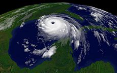
This article is all about how people got ready for Hurricane Katrina. Katrina was a super powerful storm, a Category 5 hurricane, which is the strongest kind! It hit parts of New Orleans, Florida, Louisiana, Mississippi, and Alabama really hard. We'll look at how people prepared, a practice drill called Hurricane Pam, and how weather experts tried to warn everyone. All of this led to the U.S. government looking into how well the country was ready for and reacted to Hurricane Katrina.
Contents
How People Got Ready for Hurricane Katrina
Getting Ready in South Florida
When Hurricane Katrina first hit Florida on August 25, 2005, many people in South Florida didn't know it had quickly grown from a tropical storm into a hurricane. However, the National Hurricane Center (NHC) had actually predicted it would get stronger. They sent out warnings about 6 to 8 days before the hurricane hit.
Florida's Governor, Jeb Bush, announced a state of emergency on August 24. This was to help people get ready before Katrina arrived. Shelters were opened, and schools were closed in many southern counties. Some people were told to leave their homes, especially in Martin County where it was a must for people in weaker buildings to evacuate.
Preparing Along the Gulf Coast
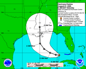
After Hurricane Katrina crossed Florida, it got even stronger, becoming a Category 3 storm. On August 27, President George W. Bush declared a state of emergency for Louisiana, Alabama, and Mississippi. This was two days before the hurricane reached land there.
On August 28, the National Weather Service office in Slidell, Louisiana sent out a special message. They warned that the damage would be "devastating," possibly as bad as Hurricane Camille had been. Because of this, many people in southeast Louisiana, coastal Mississippi, and Alabama were told they *must* leave their homes.
Big train companies also stopped their services. Canadian National Railway (CN) stopped all trains south of McComb, Mississippi. This was to prevent damage and help them restart services faster after the storm. CSX Transportation also stopped trains south of Montgomery, Alabama.
Amtrak, the passenger train service, changed its routes. Trains from Chicago that usually went to New Orleans stopped in Memphis, Tennessee instead. Trains from New York City stopped in Atlanta. And trains from Orlando, Florida, started in San Antonio, Texas instead. Amtrak said they couldn't provide other ways for people to travel into or out of the affected areas.
Even the Waterford nuclear power plant was shut down on August 28, just to be safe before Katrina arrived.
New Orleans Gets Ready
By August 26, people were starting to worry about a huge disaster in New Orleans. Some computer models showed the city right in the path of the hurricane. There was a 17% chance of a direct hit, which grew to 29% by August 28. This was a big problem because 80% of New Orleans is below sea level, near Lake Pontchartrain. Officials worried that the storm surge, which is a huge wall of water pushed by the hurricane, could go over the tops of the levees (protective walls) around the city. This would cause massive flooding. Experts like FEMA and the Army Corps of Engineers had warned for a long time that a direct hit could lead to thousands of deaths from drowning, disease, and not enough water.
At a press conference on August 28, after Katrina became a Category 5 storm, New Orleans Mayor Ray Nagin gave the first-ever mandatory evacuation order for the city. He called Katrina "a storm that most of us have long feared" and "a once-in-a-lifetime event." To help people leave faster, authorities used contraflow lane reversal. This means all lanes on highways like Interstate 10, Interstate 55, and 59 were used for traffic going *out* of the city.
The city also set up a "refuge of last resort" for people who couldn't leave. This was at the huge Louisiana Superdome. About 26,000 people stayed there with food and water for two days. The Louisiana National Guard brought in lots of water and MREs (Meals Ready-to-Eat), enough for 15,000 people for three days.
Louisiana's plan for hurricanes usually involves three phases for evacuations. People closest to the coast leave first, about 50 hours before strong winds hit. Then others leave 40 hours before, and finally, people in areas like New Orleans leave 30 hours before.
However, many areas couldn't provide enough transportation for people who didn't have their own cars. Many care homes couldn't evacuate their residents because they relied on the same bus and ambulance services. Gas and rental cars were hard to find, and public transportation stopped early. Because of this, hundreds of thousands of residents and tourists couldn't leave and stayed in the city. Still, about 90-92% of the 1.3 million people in the New Orleans area did evacuate, including 80% of Orleans parish. But more than 80,000 people were left without homes.
Hurricane Pam: A Practice Drill
Months before Hurricane Katrina actually hit New Orleans, a practice hurricane drill was done. It was called "Pam." In this drill, a Category 3 hurricane caused the levee system in New Orleans to fail, leaving the city underwater. Many emergency officials were shocked by how little was done after the Pam simulation. They worried that if a real disaster like this happened, the results would be terrible.
It was confirmed that FEMA and Louisiana state officials had seen Pam's disaster plan. The plan said that preparations for a hurricane should start three days before it hits land. But in New Orleans, the mandatory evacuation order for Katrina wasn't given until about 20 hours before the storm made landfall. Also, the Pam plan said that FEMA officials should have important supplies ready *before* the storm. They didn't do this for Katrina. While city and state governments were mainly in charge of moving people to safety, the Pam plan also pointed out that there weren't enough supplies in support shelters for Louisiana.
After Hurricane Katrina's terrible effects were clear, President Bush said he wanted an investigation. He wanted to find out how well the government had prepared for and responded to Hurricane Katrina.
Weather Forecasts and Warnings
The National Weather Service (NWS) works with several offices that focus on different parts of weather. These include the National Hurricane Center (NHC) and the Hydro-meteorological Prediction Center (HPC). The NHC is part of the National Centers for Environmental Prediction, and the HPC helps the NWS by providing weather forecasts.
The HPC also gives the NHC information about rainfall. After a tropical storm moves inland and the NHC stops its alerts, the HPC takes over watching the weather system. These two offices work closely to make sure the public gets the most accurate information.
The storm that became Hurricane Katrina was first noticed by both the NHC and HPC on August 22. After watching it for a few days, the HPC started making rainfall predictions for Katrina on August 24. On August 30, the HPC took over giving warnings about Katrina. On August 31, the hurricane system was absorbed by another weather system near the Great Lakes, so the HPC stopped its warnings for Katrina.
The NHC and HPC are very important to each other. For example, the HPC often practices being a backup for the NHC. They did many of these practice drills in the summer before Katrina hit. During Hurricane Katrina, many government emergency officials thought the NHC did an excellent job with its policies and actions. The NHC's forecasts for Hurricane Katrina were very consistent. They gave strong evidence about how intense and powerful the storm would be. The forecasts were not only accurate but also on time. This helped other emergency workers get accurate information to their teams. It was clearly predicted that Hurricane Katrina would be a huge hurricane causing terrible damage to the northern Gulf Coast.
What surprised many people after Hurricane Katrina was that the government didn't seem to do much about the clear forecasts from the NHC. It seemed obvious to many what Katrina's potential effects could be, but the storm wasn't treated with the seriousness it deserved.
| Date | Time | Warning type | Areas |
|---|---|---|---|
| August 23 | 23:00 UTC | Tropical Storm Warning | Central and northwest Bahamas |
| August 24 | 03:00 UTC | Tropical Storm Watch | Seven Mile Bridge to Vero Beach, Florida |
| 15:00 UTC | Seven Mile Bridge to Florida City, Florida | ||
| Tropical Storm Warning and Hurricane Watch | Florida City to Vero Beach, Florida | ||
| 21:00 UTC | Tropical Storm Watch | Vero Beach to Titusville, Florida | |
| Tropical Storm Warning and Hurricane Watch | Lake Okeechobee | ||
| August 25 | 03:00 UTC | Hurricane Warning | Florida City to Vero Beach, Florida, and Lake Okeechobee |
| 09:00 UTC | Tropical Storm Watch | Florida City to Englewood, Florida, including Florida Bay | |
| 15:00 UTC | Tropical Storm Warning | Grand Bahama, Bimini, and the Berry Islands, Bahamas | |
| 21:00 UTC | Hurricane Warning | Florida City to Jupiter Inlet, Florida | |
| Tropical Storm Warning | Jupiter Inlet to Florida Keys and Florida City to Longboat Key, Florida | ||
| Tropical Storm Watch | Longboat Key to Anclote Key, Florida | ||
| 23:00 UTC | Tropical Storm Warning discontinued | Grand Bahama, Bimini, and the Berry Islands, Bahamas | |
| August 26 | 03:00 UTC | Tropical Storm Watch discontinued | Vero Beach to Titusville, Florida |
| Tropical Storm Warning discontinued | Jupiter Inlet to Vero Beach, Florida | ||
| 05:00 UTC | Tropical Storm Warning | Deerfield Beach to Florida City, Florida | |
| Hurricane Warning discontinued | Deerfield Beach to Jupiter, Florida, and Lake Okeechobee | ||
| Tropical Storm Warning | Florida Keys including Florida Bay and Florida City to Longboat Key, Florida | ||
| 15:00 UTC | Florida City to Longboat Key and all the Florida Keys and Florida Bay | ||
| 21:00 UTC | Tropical Storm Watch discontinued | All | |
| Tropical Storm Warning discontinued | Florida City to Longboat Key, Florida | ||
| August 27 | 09:00 UTC | Tropical Storm Warning | Dry Tortugas to Longboat Key, Florida |
| 15:00 UTC | Dry Tortugas to Key West, Florida | ||
| Hurricane Watch | Morgan City to Pearl River, Louisiana | ||
| 21:00 UTC | Tropical Storm Warnings discontinued | All | |
| Hurricane Watch | Intracoastal City, Louisiana, to Florida-Alabama border | ||
| August 28 | 03:00 UTC | Hurricane Warning | Morgan City, Louisiana, to Florida-Alabama border, including Lake Pontchartrain |
| Tropical Storm Warning | Florida-Alabama border to Destin, Florida | ||
| Intracoastal City to Morgan City, Louisiana | |||
| Hurricane Watch | Florida-Alabama border to Destin, Florida | ||
| 09:00 UTC | Tropical Storm Warning | Destin to Indian Pass, Florida, and Intracoastal City to Cameron, Louisiana | |
| August 29 | 15:00 UTC | Hurricane Watches discontinued | All |
| 21:00 UTC | Tropical Storm Warning | Pearl River, Louisiana, to Florida-Alabama border | |
| Tropical Storm and Hurricane Warning discontinued | Cameron to Pearl River, Louisiana, and Florida-Alabama border to Destin, Florida | ||
| August 30 | 03:00 UTC | Tropical Storm Warning discontinued | All |
Government Committee Investigates
On September 15, 2005, it was announced that a special committee was formed. This committee had members from both major political parties. Their job was to investigate how the United States government prepared for and responded to Hurricane Katrina.
Related pages
 | William L. Dawson |
 | W. E. B. Du Bois |
 | Harry Belafonte |


