
St. Rose, Louisiana facts for kids
Quick facts for kids
St. Rose, Louisiana
Saint Rose
|
|
|---|---|

St. Rose, Louisiana
Location in Louisiana
|
|
| Country | United States |
| State | Louisiana |
| Parish | St. Charles |
| Area | |
| • Total | 7.45 sq mi (19.31 km2) |
| • Land | 6.34 sq mi (16.42 km2) |
| • Water | 1.11 sq mi (2.89 km2) |
| Elevation | 10 ft (3 m) |
| Population
(2020)
|
|
| • Total | 7,504 |
| • Density | 1,183.78/sq mi (457.04/km2) |
| Time zone | UTC-6 (CST) |
| • Summer (DST) | UTC-5 (CDT) |
| ZIP code |
70087
|
| Area code(s) | 504 |
| FIPS code | 22-67740 |
Saint Rose (often called St. Rose) is a community in St. Charles Parish, Louisiana, United States. It's known as a census-designated place (CDP), which means it's a special area defined for gathering population information.
St. Rose is located on the east side of the Mississippi River. It is about two miles (3 km) north of the Jefferson Parish border. This community is part of the larger Greater New Orleans metropolitan area. In 2000, about 6,540 people lived there. By 2020, the population had grown to 7,504.
Contents
History of St. Rose
One important historical building in St. Rose is the LaBranche Plantation Dependency House. This building is one of the few parts left from the old LaBranche Plantation. The main house of the plantation was built in 1792 by the Zweig family.
The plantation grew and processed sugar cane. This work relied on the labor of enslaved people. The main plantation house was destroyed during the Civil War. After the war, one of the few buildings that remained was the dependency house. This building was also called a garconnière, which is a French word for bachelor quarters. There is also a preserved building on the property that was once part of the slave quarters.
In 1873, a man named Palmer Elkins bought land in St. Rose. In 1880, he invited freedmen (people who had been enslaved and were now free) and their families to live on his property. He wanted to offer them training. This area became known as "Elkinsville" or "Freetown."
Geography of St. Rose
St. Rose is located at 29°57′38″N 90°18′47″W / 29.96056°N 90.31306°W.
The United States Census Bureau says that St. Rose has a total area of about 5.0 square miles (13.0 km2). Most of this area, about 4.0 square miles (10.5 km2), is land. The rest, about 1.0 square mile (2.6 km2), is water. This means that about 19.88% of St. Rose is covered by water.
People in St. Rose
| Historical population | |||
|---|---|---|---|
| Census | Pop. | %± | |
| 2020 | 7,504 | — | |
| U.S. Decennial Census | |||
The table below shows the different groups of people living in St. Rose as of 2020:
| Race | Number | Percentage |
|---|---|---|
| White (not Hispanic) | 3,063 | 40.82% |
| Black or African American (not Hispanic) | 3,028 | 40.35% |
| Native American | 13 | 0.17% |
| Asian | 158 | 2.11% |
| Pacific Islander | 3 | 0.04% |
| Other/Mixed | 258 | 3.44% |
| Hispanic or Latino | 981 | 13.07% |
As of the 2020 United States census, there were 7,504 people living in St. Rose. These people lived in 2,914 households, and 1,905 of these were families.
Education in St. Rose
The St. Charles Parish Public School System runs the public schools in St. Rose. These schools include:
- St. Rose Elementary School (for grades PK-5)
- Albert Cammon Middle School (for grades 6-8)
- Destrehan High School in Destrehan (for high school students)
Famous People from St. Rose
Many notable people have come from St. Rose, including:
- Macon Clark, an NFL safety who played for the Chicago Bears
- Burnell Dent, an NFL linebacker for the Green Bay Packers and New York Giants
- Snooks Eaglin, a talented guitarist and singer
- Roy Ebron, a basketball player in the ABA
- Shelley Hennig, who was Miss Teen USA in 2004 and is now an actress
- Jordan Jefferson, an NFL quarterback for the Tampa Bay Buccaneers
- Justin Jefferson, an NFL wide receiver for the Minnesota Vikings
- Curtis Johnson, a head football coach at Tulane University and an NFL assistant coach
- Beulah Levy Ledner, a famous dessert and pastry chef
- Ed Reed, a safety who is in the College Football Hall of Fame and NFL Hall of Fame. He played for the Baltimore Ravens, Houston Texans, and New York Jets.
- Darryl Richard, an NFL defensive tackle for the New England Patriots
- Margaret Taylor-Burroughs, who helped start the DuSable Museum of African American History in Chicago
- Gary Tyler, who was believed to have been wrongly found guilty of a crime in 1974 and was released in 2016.
- Josh Victorian, an NFL cornerback who played for several teams, including the Baltimore Ravens and New Orleans Saints
- Darius Vinnett, an NFL cornerback for the St. Louis Rams and Atlanta Falcons
- Michael Young Jr., an NFL wide receiver for the Indianapolis Colts
Images for kids
-
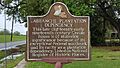
LaBranche Plantation Dependency House historical marker
-
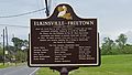
Elkinsville-Freetown historical marker
,_2009.jpg)

.jpg)
See also
 In Spanish: St. Rose (Luisiana) para niños
