Avondale, Louisiana facts for kids
Quick facts for kids
Avondale, Louisiana
|
|
|---|---|

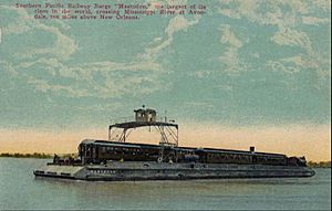
Postcard photo of the Southern Pacific railroad barge Mastodon crossing the Mississippi River at Avondale, Louisiana. The railroad also had railroad ferries which worked in the San Francisco area for the same purpose.
|
|
| Country | United States |
| State | Louisiana |
| Parish | Jefferson |
| Area | |
| • Total | 5.99 sq mi (15.51 km2) |
| • Land | 5.56 sq mi (14.39 km2) |
| • Water | 0.43 sq mi (1.12 km2) |
| Elevation | 3 ft (0.9 m) |
| Population
(2020)
|
|
| • Total | 4,582 |
| • Density | 824.55/sq mi (318.35/km2) |
| Time zone | UTC-6 (CST) |
| • Summer (DST) | UTC-5 (CDT) |
| ZIP Code |
70094
|
| Area code(s) | 504 |
| FIPS code | 22-03810 |
| GNIS feature ID | 542944 |
Avondale is a community located in Jefferson Parish, Louisiana, in the United States. It sits on the west side of the mighty Mississippi River. In 2020, about 4,582 people lived here. Avondale is also part of the larger New Orleans area, which includes nearby cities like Metairie and Kenner.
Geography of Avondale
Avondale is found at 29°54′16″N 90°12′15″W / 29.90444°N 90.20417°W. It is on the "West Bank" of the Mississippi River. To its west is Waggaman, and to its east is Bridge City. Across the Mississippi River to the north is the city of Harahan.
The closest way to cross the Mississippi River by road is the Huey P. Long Bridge. This bridge is about 4 miles (6.4 km) northeast of Avondale. It carries U.S. Route 90. Downtown New Orleans is about 13 miles (21 km) northeast of Avondale by road.
The community of Avondale covers a total area of about 15.5 square kilometers (5.99 sq mi). Most of this area, about 14.4 square kilometers (5.56 sq mi), is land. The rest, about 1.1 square kilometers (0.43 sq mi), is water.
People in Avondale
| Historical population | |||
|---|---|---|---|
| Census | Pop. | %± | |
| 2000 | 5,441 | — | |
| 2010 | 4,954 | −9.0% | |
| 2020 | 4,582 | −7.5% | |
| U.S. Decennial Census | |||
In 2020, the population of Avondale was 4,582 people. This number has changed over the years. For example, in 2000, there were 5,441 people, and in 2010, there were 4,954.
The community of Avondale is made up of people from many different backgrounds. Here's a look at the racial makeup in 2020:
| Group | Number of People | Percentage |
|---|---|---|
| White (not Hispanic) | 1,894 | 41.34% |
| Black or African American (not Hispanic) | 1,444 | 31.51% |
| Native American | 19 | 0.41% |
| Asian | 494 | 10.78% |
| Other/Mixed backgrounds | 176 | 3.84% |
| Hispanic or Latino | 555 | 12.11% |
In 2020, there were 1,729 households and 1,239 families living in Avondale. Many people in Avondale speak languages other than English. For example, some speak Spanish, and others speak Asian and Pacific Islander languages.
The average income for a household in Avondale was $40,503 in 2019. About 14.8% of the people in Avondale lived at or below the poverty line.
Education in Avondale
Public schools in Avondale are run by Jefferson Parish Public Schools.
Most students in Avondale go to Gilbert PreK-8 School. This school used to be called Henry Ford Middle School until 2019. A smaller part of the community goes to Cherbonnier K-8 School. All high school students attend L.W. Higgins High School in Marrero.
For students who want to study advanced subjects, there are special academies. Residents of Avondale can go to the Marrero Academy or the Patrick F. Taylor Science and Technology Academy.
See also
 In Spanish: Avondale (Luisiana) para niños
 | Janet Taylor Pickett |
 | Synthia Saint James |
 | Howardena Pindell |
 | Faith Ringgold |


