Plains of Abraham facts for kids
Quick facts for kids Plains of Abraham |
|
|---|---|
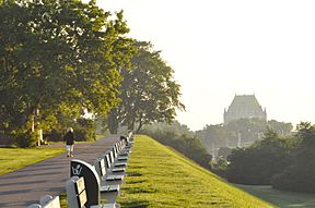
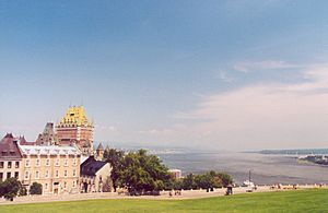
Plains of Abraham in summer
|
|
| Location | Quebec City, Quebec, Canada |
| Area | 98 ha (240 acres) |
| Established | 17 March 1908 |
| Governing body | National Battlefields Commission (Canadian Crown) |
The Plains of Abraham (French: Plaines d'Abraham) is a famous historic area in Quebec City, Quebec, Canada. This land was the site of the important Battle of the Plains of Abraham on September 13, 1759. For many years, parts of the fields were used for grazing animals, homes, and small factories.
In 1908, the land became part of Quebec City. It is now managed by the National Battlefields Commission, a special group created by the Canadian government. Today, about 4 million people visit the park each year. They come for sports, relaxing, outdoor concerts, and festivals.
Contents
Plains of Abraham Museum: Learn About History
The Plains of Abraham Museum is the main information center for the park. It has a cool multi-media exhibit about the siege of Québec. You can also learn about the battles of the Plains of Abraham in 1759 and 1760.
Other displays show the history of the area through old objects found in the park. The museum is open all year. It's a great place to start your visit and even has a gift shop.
What's in a Name? The Plains' Features
The Plains are probably named after Abraham Martin (1589–1664). He was a fisherman and river guide, sometimes called "The Scot." Martin moved to Quebec City in 1635. He received 32 acres of land from the Company of New France.
Abraham's name appeared on maps and in land records during the time of New France. Old documents from the 17th and 18th centuries mention "Abraham's coast." A 1734 map even shows an "Abraham Street." Later, soldiers' diaries from both the French and British sides called the area "Heights of Abraham" or "Plains of Abraham."
The park is about 2.4 kilometers (1.5 miles) long and 0.8 kilometers (0.5 miles) wide. It covers 98 hectares (242 acres). It stretches west from the Citadelle of Quebec and the city walls. The park sits on a high flat area above the Saint Lawrence River. It is part of The Battlefields Park.
You can find walking trails and an information center here. There are also monuments to remember the Battle of Sainte-Foy and James Wolfe. A special marker for Wolfe was put up in 1790. It shows where he was believed to have died.
In 1913, a column was placed on the site, just like one built in 1849. A replica of the Cross of Sacrifice was also built. This cross remembers soldiers lost in World War I. Remembrance Day ceremonies are still held here every year.
History: Battles and Preservation
On September 13, 1759, the Plains of Abraham were the site of a very important battle. This battle was part of the French and Indian War, which was itself part of the larger Seven Years' War.
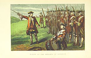
On that day, British soldiers led by General Wolfe climbed the steep cliff in the dark. They surprised and defeated the French forces. The battle was quick, lasting only about 30 minutes. Both General Wolfe and the French commander, the Marquis de Montcalm, died from their injuries. The British won control of Quebec City, which helped them take control of Canada the next year.
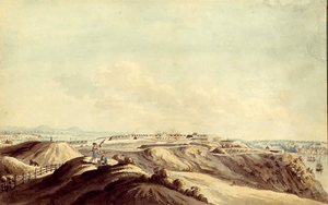
After the battle, the plains remained mostly open fields. Only a monument to Wolfe reminded people of the events. As Quebec City grew, buildings started to appear on the plains. Hundreds of acres were built over.
In 1901, the government stepped in. They stopped a plan to build on 88 acres by buying the land. However, another part of the plains was used for a rifle factory. This happened despite public protests.
People continued to push for the site to be saved. By 1904, the Literary and Historical Society of Quebec was allowed to put up plaques. These plaques marked important spots around the area. The next year, a plan to create an Historic Landmarks Association was proposed. Governor General the Earl Grey began his own plan to save the battlefields. He said he would not rest until this "sacred ground" belonged to all of Canada.
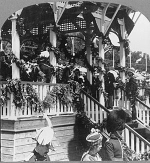
In 1908, the Mayor of Quebec City, Jean-Georges Garneau, formed a special commission. This group suggested that the Quebec battlefields should become national property. They also wanted a museum of Canadian history.
The federal prime minister at the time, Wilfrid Laurier, thought preserving the plains themselves would be a better tribute. This matched Earl Grey's wishes. On March 17, the park was officially created. It became the first National Historic Site in Canada. It was placed under the care of the new National Battlefields Commission.
On July 24, 1908, Prince George, Prince of Wales (who later became King George V), officially opened the Quebec Battlefields Park. He gave the land deeds to the Governor General. Quebec residents loved these events. Laurier even said that Quebecers were "monarchical by religion, by habit, and by the remembrance of past history."
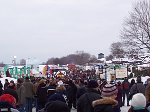
Today, the Plains of Abraham is a popular urban park in Quebec City. The National Battlefields Commission compares its use to Central Park in New York City or Hyde Park in London. Many events are held here, especially during the Fête nationale du Québec, the Quebec Winter Carnival, and the Quebec City Summer Festival.
Recognition: How the Plains are Remembered
The Plains of Abraham have been recognized in different ways. On September 10, 1959, Canada Post released a special stamp called "Plains of Abraham, 1759–1959." It was designed by Ephrum Philip Weiss.
The site is also mentioned in several songs. These include "Acadian Driftwood" by The Band (1975), "The Maker" by Daniel Lanois, and "Nous Vivons Ensemble" by Gordon Lightfoot (1971). Geddy Lee also mentions the site in his song "My Favourite Headache" (2000).
See also
 In Spanish: Llanuras de Abraham para niños
 | Shirley Ann Jackson |
 | Garett Morgan |
 | J. Ernest Wilkins Jr. |
 | Elijah McCoy |


