
Promontory of Quebec facts for kids
The promontory of Quebec is a high, cliff-like area in Quebec City, Canada. It's where the upper part of the city is built, including the historic Old Quebec neighborhood. This part of the promontory is also known as Cap Diamant. The promontory is the eastern half of a larger flat-topped hill, or plateau, often called the "Quebec hill." The western part of this plateau holds the upper areas of Sainte-Foy–Sillery–Cap-Rouge.
Contents
History of the Quebec Promontory
The promontory has played an important role in Quebec City's history. Its very steep southern side was famously climbed by British soldiers in September 1759. They surprised the French army, leading to the important Battle of the Plains of Abraham.
Getting Up and Down the Promontory
The steep cliffs of the promontory have always made it tricky to travel between the lower and upper parts of the city. Today, there are several ways to get around:
- Roads: Regular streets connect the different levels.
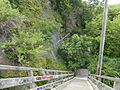
- Escalator: A free escalator called du Faubourg helps people go up and down easily.
- Funicular: The Old Quebec Funicular is a special cable car that carries passengers up the steep slope.
- Stairs: There are 20 official sets of stairs connecting the lower and upper towns.
The longest staircase is the escalier du Cap-Blanc with 398 steps. It was designed in 1868 and leads to the south of the Plains of Abraham. The second longest is the Franciscains stairs, with 177 steps, going up to the Montcalm neighborhood. The shortest public staircase is the Quai-du-Roi in the Petit Champlain area, with 30 steps.
Dealing with Rockfalls
Over the years, the cliffs have sometimes caused rockfalls. Since 1775, 53 rockfalls have been recorded, causing 88 deaths and 70 injuries. They also destroyed 20 houses. Two major events were:
- The rockslide of 1841, which killed 32 people.
- The rockslide of 1889, which killed 35 people.
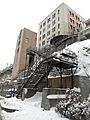
The 1889 rockslide happened because a drain from the Citadelle of Quebec became blocked. Water built up pressure, causing the rock to break apart. To prevent future incidents, special nets and fences were put in place during the 20th century. These safety measures have greatly reduced the number of rockfalls.
Geography of the Quebec Hill
The entire plateau, which includes the promontory of Quebec, is about 13 kilometers (8 miles) long. It is widest in the west, at about 4 kilometers (2.5 miles), and narrower in the east, near Old Quebec, where it averages 1 kilometer (0.6 miles) wide. The highest point of the hill is in the former city of Sainte-Foy, reaching about 110 meters (360 feet) high.
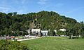
The hill is bordered by the Saint-Charles River to the northeast and the Saint Lawrence River to the south. Near the Plains of Abraham, just west of Cap Diamant (which is about 100 meters or 330 feet high), you can see white-cedar trees growing right on the rocks. This area is called "Cap-Blanc" (White Cape). It might be a translation of an Innu name. In the past, before the 20th century, there were fewer trees here, so the grey rock was more visible. This grey color was a contrast to the reddish rocks at the southwestern end of the hill, known as Cap-Rouge (Red Cape).
How the Hill Was Formed
Geologically, the Quebec hill is part of the Appalachian Mountains. It's the only part of these mountains that extends north of the Saint Lawrence River. Along the northern side of the plateau runs the Logan's Fault. This is an important inactive thrust fault that marks the boundary between the Appalachian mountains and the Saint Lawrence Lowlands.
The western side of the plateau is mostly made of sandstone and mudstone. Closer to Old Quebec, the eastern half rests on stony schist. Early settlers used these schist stones for building material, but they were later found to be of poor quality. Builders then started using sandstone from Sillery and limestone from quarries in nearby areas like Beauport, Sainte-Anne-de-Beaupré, and Saint-Marc-des-Carrières. Beneath the entire plateau, the ground is mostly made of sand and pebbles. These materials were left behind when the ancient Champlain Sea retreated after the last ice age.
Images for kids
-
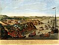
An old painting (around 1797) showing British soldiers climbing the promontory.
-
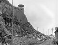
The damage after the rockslide of 1889.
-
The cedars growing on the cliffs of Cap-Blanc.
-
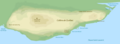
A map showing the shape of the Quebec plateau.
-
A rockfall net behind des Glacis stairs.
-
Southward view from Autoroute 73.
-
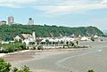
View from the Saint Lawrence's cove of Anse-au-Foulon with Cap Diamant on the east.
-
du Faubourg escalator and stairs.
-
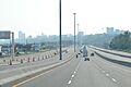
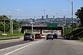
Autoroute 440 runs along the northern flank of the hill.


_-_Sud.JPG)


