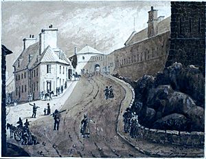
Ramparts of Quebec City facts for kids
Quick facts for kids Fortifications of Québec National Historic Site |
|
|---|---|
| Native name French: Lieu historique national des Fortifications-de-Québec |
|
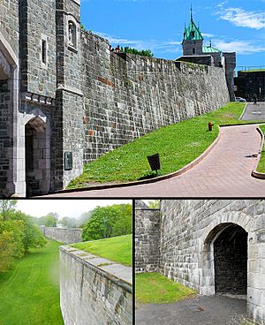
Multiple views of the ramparts of Quebec
|
|
| Type | City wall |
| Location | Quebec City, Quebec, Canada |
| Built | 1690 |
| Rebuilt | 1745, 1820–1830s |
| Architect | Gaspard-Joseph Chaussegros de Léry (1745) Gother Mann (1820–1830s) |
| Governing body | Parks Canada |
| Official name: Fortifications of Québec National Historic Site of Canada | |
| Designated | 25 May 1948 |
The ramparts of Quebec City are old city walls that surround the western part of Old Quebec's Upper Town in Quebec City, Quebec, Canada. These walls were first built in the 1600s. They have been changed and improved many times over the years.
The city walls stretch for about 4.6 kilometers (2.9 miles). The southern parts of the ramparts are also part of the Citadelle of Quebec. The ramparts were originally built in 1690 to protect Quebec City's Upper Town. In 1745, they were rebuilt further west, following designs by Gaspard-Joseph Chaussegros de Léry.
These walls helped Quebec City survive several attacks in the mid-1700s. British soldiers used them to defend against a French attack in 1760. They also helped against an American attack in 1775. From the 1820s to the 1830s, the British made the ramparts even stronger. In 1948, the ramparts became part of the larger Fortifications of Québec National Historic Site. In 1985, the fortifications and Old Quebec became a UNESCO World Heritage Site. This area is the only fully intact fortified colonial settlement in North America north of Mexico.
Contents
How Quebec City's Walls Were Built
Building temporary defenses for Quebec City started soon after the French settled here in 1608. The first settlement, called the Habitation de Québec, had a trading post, homes, and a small fort with raised walls. From 1620 to 1665, simple forts were built to protect the city.
The city's first real defensive walls were put up in 1690. This happened shortly after the British took Port Royal. The walls were finished before the Battle of Quebec in 1690. Work on a better wall system, called an enceinte, began a few years later in 1693. This enceinte was built around the city. It had 11 small forts connected by wooden fences. Most of Quebec's Upper Town was on the steep cliffs of Cap Diamant. So, protecting the western edge of Upper Town, which faced the Plains of Abraham, was the most important task.
Improving the Fortifications
Changes and additions were made to the walls until 1745. After the Fortress of Louisbourg fell to the British in 1745, people in Quebec City became very worried. Because of this, François de Beauharnois de la Chaussaye, Baron de Beauville, who was the Governor General of New France, ordered a new stone wall to be built. He did this without getting approval from France.
This new wall was based on designs by Gaspard-Joseph Chaussegros de Léry. It was built further west than the first wall to make room for the growing city.
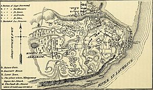
However, the 1745 design had some problems. Parts of the wall were exposed to higher ground further west. Also, it was built quickly because everyone was in a panic. By 1759, the ramparts were in bad shape. French commanders noticed this before the Battle of the Plains of Abraham. The poor condition of the walls was one reason why General Louis-Joseph de Montcalm gathered his soldiers outside the city on the Plains of Abraham to fight the British. This battle led to Quebec surrendering.
The city's ramparts were then used by the British. They helped the British hold out against a French attack in 1760 until more soldiers arrived. The walls were used again 15 years later. In 1775, British and Canadian soldiers used them to stop another attack by American forces.
British Improvements and Preservation
Even though British officials in Quebec wanted to improve the city's defenses, not much was done for many years. The British only made necessary repairs. The American Revolutionary War made them more interested in strengthening the city's defenses. Temporary forts were built on Cap Diamant.
New plans were later made by Gother Mann. These plans included making the 1745 ramparts longer and adding more defenses. They also included building a citadel on Cap Diamant. Construction based on these plans started in 1820. Most of the plan was completed by the late 1830s, including the Citadelle of Quebec.
Around 300 cannons were placed on the ramparts in 1837. In the mid-1800s, the needs of the military often clashed with the city's growth. When British soldiers left the city in 1871, some parts of the old forts were torn down to make way for new buildings. This included the old military gates of the ramparts.
Many old parts of the city's defenses were torn down in the late 1800s. However, the main walls of the city remained. This was thanks to the Governor General of Canada, Lord Dufferin, who stepped in to save them.
On May 25, 1948, the ramparts of Quebec City, along with other buildings linked to Quebec's defenses, were named a National Historic Site of Canada. In 1985, the ramparts and the rest of Old Quebec became a UNESCO World Heritage Site. Old Quebec is special because it is the only complete example of a fortified colonial settlement in North America north of Mexico.
Design and Layout of the Walls
The ramparts of Quebec City are located on top of Cap Diamant, a large hill in the city. The walls surround the western parts of Old Quebec's Upper Town. The other sides of Upper Town are protected by steep cliffs that drop about 90 meters (300 feet). The total length of the ramparts is about 4.6 kilometers (2.9 miles). They were first built in the 1600s, rebuilt in 1745 by the French, and then improved and extended by the British in the 1820s and 1830s.
Wood and green sandstone from Sillery were used to build much of the fortifications. An underground artillery battery was built into the ramparts in the 1750s. This was called the flank blockhouse. It was built to make the weakest part of the ramparts stronger by doubling the number of cannons there. Its openings can still be seen at the Citadelle today. Small holes in the wall allowed people to go to the outer defenses when the city gates were closed.
The ramparts of Quebec City are part of the Fortifications of Québec National Historic Site of Canada. This site includes many places linked to the historic defenses of the city's Upper Town and Lower Town. These defenses stretch along the north shore of the Saint Lawrence River to the Montmorency River in Beauport. Other related sites are on the south shore of the river in Lévis.
These sites include the ramparts themselves, plus other important parts like barracks (where soldiers lived), guard posts, magazines (for storing gunpowder), Martello towers, and storehouses. Examples include the Esplanade powder magazine, the powder magazine on Hôtel-Dieu de Québec's property, the Dauphin redoubt, the Lévis Forts, and the Citadelle of Quebec. Parts of the Citadelle of Quebec are actually connected to the city's ramparts. All these sites date from 1608 to 1871.
At one time, the defensive system around Upper Town was about 75 meters (246 feet) deep. This included the city walls, ditches, outer defenses, and a gentle slope called a glacis. However, this defensive area was later made smaller to allow for new buildings west of the city walls.
City Gates of Quebec
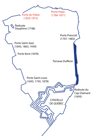
There are four main city gates built into the ramparts. These gates let people enter Old Quebec's Upper Town. They are Kent Gate, Prescott Gate, Saint-Jean Gate, and Saint-Louis Gate. In the mid-1700s, the ramparts had three city gates. Several more gates were built in the mid-1800s. However, two gates, Palace Gate and Hope Gate, were torn down in the 1800s. This left the ramparts with four city gates. There were plans to tear down the Saint-Jean and Saint-Louis gates in 1871, but Lord Dufferin stopped this from happening.
Kent Gate was built in 1879. It was named after Queen Victoria's father, Prince Edward Augustus, Duke of Kent and Strathearn. Prescott Gate has been in its location since 1797. It was rebuilt twice, in 1871 and again in 1983. This gate was named by and after Robert Prescott.
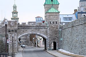
Rue St-Jean passes through Saint-Jean Gate. Its current location dates back to 1770. The original Saint-Jean Gate was further east on Rue St-Jean and was built in 1693. The gate was rebuilt at its current spot in 1770, but it was torn down and rebuilt again in 1865. From 1770 to 1871, the gate doors were closed at night. This made local trade difficult. The doors were removed permanently in 1871, allowing traffic to flow freely into Upper Town on Rue St. Jean. The gates were rebuilt again in 1939. This was done to make the gate look more like Kent Gate and Saint-Louis Gate.
Saint-Louis Gate is built on rue Saint-Louis. Its location goes back to the late 1600s. However, the current gate was built in 1878. It replaced the older gate with one that was considered more "beautiful." Like Saint-Jean Gate, the doors of Saint-Louis Gate were closed at night. This also stopped local traffic until they were permanently removed in 1871.
 | Aurelia Browder |
 | Nannie Helen Burroughs |
 | Michelle Alexander |


