
Montmorency River facts for kids
Quick facts for kids Montmorency River |
|
|---|---|

Mouth of the Montmorency River
|
|
| Other name(s) | Rivière Montmorency |
| Country | Canada |
| Province | Quebec |
| Region | Capitale-Nationale |
| RCM | La Jacques-Cartier Regional County Municipality, La Côte-de-Beaupré Regional County Municipality and Quebec (city) |
| Physical characteristics | |
| Main source | Moran Lake Lac-Jacques-Cartier Unorg. Terr. 845 m (2,772 ft) 47°34′42″N 71°04′45″W / 47.57833°N 71.07917°W |
| River mouth | Saint Lawrence River Boischatel 4 m (13 ft) 46°53′06″N 71°08′36″W / 46.88500°N 71.14333°W |
| Length | 103.7 km (64.4 mi) |
| Basin features | |
| Basin size | 1,150 km2 (440 sq mi) |
| Tributaries |
|
The Montmorency River is a beautiful river in Quebec, Canada. It flows into the Saint Lawrence River near Quebec City. This river is famous for the amazing Montmorency Falls, which are taller than Niagara Falls!
The river is about 103.7 km (64.4 mi) long. It starts from Moran Lake and flows south. The Montmorency River passes through different areas, including Lac-Jacques-Cartier, Château-Richer, L'Ange-Gardien, Boischatel, Sainte-Brigitte-de-Laval, and parts of Quebec City.
The amount of water flowing in the river changes a lot. On average, it carries about 35.6 m3/s (1,260 cu ft/s) of water. In summer, it's around 25 m3/s (880 cu ft/s). But in spring, when snow melts, it can swell to 130 to 650 m3/s (4,600 to 23,000 cu ft/s)! Very big floods, like the one in November 1966, can see flows up to 1,100 m3/s (39,000 cu ft/s).
Contents
Exploring the Montmorency River's Geography
The Montmorency River begins its journey in Lake Montmorency. It flows south through a wild area called the Laurentides Wildlife Reserve. As it moves, the river carves its way between tall, rocky cliffs, some reaching over 600 metres (1,969 ft) high. Further downstream, it flows through towns like Sainte-Brigitte-de-Laval and Boischatel. Here, you'll find many fast-moving sections called rapids before the river plunges 83 metres (272 ft) down the incredible Montmorency Falls.
The River's Water Basin
The area of land that drains water into the Montmorency River is called its watershed basin. This basin is mostly covered by forests, about 92% of it! It also has 424 lakes. The biggest lake in this area is Lac des Neiges, which means "Lake of Snow." This lake is the source of the rivière des Neiges, the Montmorency's largest branch. Only a small part of the basin, about 2%, is used for cities and towns, and 1% for farming.
Main Branches of the Montmorency River
The Montmorency River has several important branches, called tributaries, that flow into it. Here are some of the larger ones:
- Noire River
- rivière des Neiges
- Smith River (also known as de la Décharge)
- rivière à l'Île
- rivière aux Pins
- Ferrée River
A Journey Through Time: History of the Montmorency River
.jpg)
The Montmorency River has a rich history! In 1608, a famous explorer named Samuel de Champlain visited the falls at the river's mouth. He was so impressed that he named them "the great falls of Montmorency." He did this to honor Charles de Montmorency, a French admiral. Over time, the name of the falls was given to the entire river.
Early Settlements and Conflicts
People started settling near the mouth of the Montmorency River around 1664, in what is now the town of Boischatel. Later, in 1759, during a war, the river played a big role. The British General James Wolfe found the Montmorency River a major challenge. It stopped him from attacking Quebec City from the east. This forced him to find another way, leading to the famous Battle of the Plains of Abraham. You can still find parts of an old fort built by Wolfe on the east side of the falls!
Industry and Tourism Development
In the 1800s, more people moved inland along the river. They started cutting down trees for wood, a process called log driving. The river's power was also used to build a hydro-electric dam and a sawmill near the falls. After the logging era, textile factories grew near the river's mouth.
In 1992, the area around the Montmorency Falls became a park. It was developed for visitors with new viewing spots, stairs, a bridge, and even a cable car! This made it easier for everyone to enjoy the amazing falls.
Wildlife of the Montmorency River
The Montmorency River and its surrounding basin are home to many interesting animals.
Fish Species in the River
The most common fish you'll find here are different types of trout, including rainbow trout, lake trout, and brook trout. Other fish that live in the river include the longnose sucker, white sucker, slimy sculpin, and pearl dace.
Amphibians and Reptiles
The river basin also has two types of reptiles: the common garter snake and the red-bellied snake. There are also eight kinds of amphibians, which are animals that can live both on land and in water. These include the American toad, wood frog, green frog, spring peeper, red-backed salamander, dusky salamander, northern two-lined salamander, and the eastern newt.
What's in a Name? The Toponymy of Montmorency
The name "Montmorency River" comes from the impressive falls near its mouth. In 1608, the explorer Samuel de Champlain called these falls "le grand saut de Montmorency," which means "the big jump of Montmorency." He named them after Charles de Montmorency (1537-1612), a French duke and admiral. Champlain had dedicated his exploration stories to him.
Later, around 1641, a map by Jean Bourdon showed the river as "Saut de Montmorency." This shows how the name of the falls became the name of the whole river. The official name "Montmorency river" was formally recognized on December 5, 1968, by the Commission de toponymie du Québec, which is like a naming committee for places in Quebec.
Images for kids
-
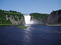
Montmorency Falls
-
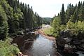
The Montmorency River flowing through the landscape.


