
Athabasca River facts for kids
Quick facts for kids Athabasca River |
|
|---|---|
.jpg)
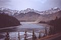
Athabasca River in Jasper National Park
|
|

Athabasca River watershed in western Canada
|
|
| Country | Canada |
| Province | Alberta |
| Physical characteristics | |
| Main source | Columbia Icefield Jasper National Park 1,520 m (4,990 ft)(foot of glacier) 52°10′4″N 117°25′50″W / 52.16778°N 117.43056°W |
| River mouth | Lake Athabasca 205 m (673 ft) 58°37′35″N 110°50′5″W / 58.62639°N 110.83472°W |
| Length | 1,231 km (765 mi) |
| Basin features | |
| Basin size | 95,300 km2 (36,800 sq mi) |
The Athabasca River is a long river in Alberta, Canada. It starts high up in the mountains at the Columbia Icefield in Jasper National Park. The river flows for more than 1,231 km (765 mi) before it reaches Lake Athabasca.
Many areas along the river are protected as national and provincial parks. The Athabasca River is also known as a Canadian Heritage River. This means it is important for its history, culture, and natural beauty. You can find the beautiful Athabasca Falls about 30 km (19 mi) from Jasper.
Contents
What's in a Name?
The name Athabasca comes from the Woods Cree language. The word aðapaskāw means "where there are plants one after another." This probably refers to how plants grow in patches along the river.
The River's Journey
The Athabasca River begins in Jasper National Park. It starts from a lake at the bottom of the Columbia Glacier, which is part of the Columbia Icefield. This spot is very high up, about 1,600 metres (5,200 ft) above sea level.
The river travels 1,231 km (765 mi) to the Peace–Athabasca Delta near Lake Athabasca. From there, its waters flow north into the Arctic Ocean through a system of other rivers like the Peace River and Mackenzie River. The total area drained by the Athabasca River and its branches is about 95,300 km2 (36,800 sq mi).

The river flows past icefields and through deep gorges. Its banks and nearby wetlands are home to many different animals. Along its path, the river goes through or next to several national and provincial parks. These include Jasper National Park and Wood Buffalo National Park. Some parts of the river have rapids, which make it hard for boats to travel.
Many towns and cities are located along the Athabasca River. Some of these include Jasper, Hinton, Whitecourt, Athabasca, and Fort McMurray.
Rivers Joining the Athabasca
Many smaller rivers and creeks flow into the Athabasca River. These are called tributaries. They add water to the main river as it travels.
|
|
|
A Look Back in Time
Long before Europeans arrived, Indigenous tribes like the Sekani, Stoney, and Cree lived along the Athabasca River. They hunted and fished there.
Around 1778, the Athabasca River became a very important route for the North American fur trade. Fur traders used the river to move goods and furs between the Mackenzie River and the Great Lakes.

In 1811, explorer David Thompson traveled through the Athabasca Pass. Later, in 1862, a group called the Overlander Party crossed the Athabasca Springs area during the Cariboo Gold Rush.
The northern part of the Athabasca River became a major shipping route in 1921. This happened when a railway reached Waterways, near Fort McMurray. This made Waterways the northernmost point on the North American railway system at that time. Goods heading further north were loaded onto barges there. These barges were then pulled by tugboats up the river.
Caring for the River
The Athabasca River flows near the Athabasca oil sands, which is an area where oil is extracted from the ground. Because of this, there are many energy buildings and pipelines along the river.
Sometimes, accidents can happen. For example, in 1970, a pipeline broke near the river. Also, studies have shown that the river downstream from the oil sands can have higher levels of certain elements.
Coal Mine Spill
In 2013, a coal mine had a large spill. A lot of muddy waste flowed into nearby creeks and then into the Athabasca River. This waste traveled over 500 km (310 mi) down the river and settled in Lake Athabasca.
River's Special Status
The Athabasca River is a Canadian Heritage River. This is because of its important role in the fur trade and in opening up the Canadian West with railways and roads. It is also recognized for its amazing natural environment.
The Canadian Heraldic Authority even named a special position, the Athabaska Herald, after this important river.
Gallery
-
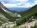
Athabasca River Valley seen from the Geraldine Lakes
-
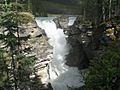
Flowing through the Athabasca Falls
-
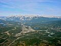
Passing by Jasper
-
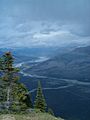
Athabasca River valley from the Pallisades fire lookout
-
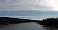
Athabasca River at the mouth of Brûlé Lake
-
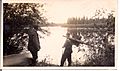
Dr. Karl Clark and guide Romeo Eymundson on the bank of the Athabasca River.
-
Upstream from Whitecourt
-
Bituminous sand banks north of Fort McMurray


.jpg)


Images for kids
-
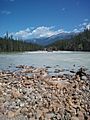
Athabasca River in July, 2013
-
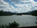
Athabasca River in Jasper
-
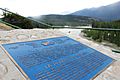
Plaque overlooking the river in Jasper National Park, 2015


See also
 In Spanish: Río Athabasca para niños
