
Whitecourt facts for kids
Quick facts for kids
Whitecourt
|
||
|---|---|---|
|
Town
|
||
| Town of Whitecourt | ||

Whitecourt's entrance sign on Highway 43
|
||
|
||
| Nickname(s):
Snowmobile Capital of Alberta
|
||
| Motto(s):
Let's Go...
|
||

Location in Woodlands County
|
||
| Lua error in Module:Location_map at line 416: Malformed coordinates value. | ||
| Country | Canada | |
| Province | Alberta | |
| Planning region | Upper Athabasca | |
| Municipal district | Woodlands County | |
| Founded | 1910 | |
| Incorporated | ||
| • Village | January 1, 1959 | |
| • New town | August 15, 1961 | |
| • Town | December 20, 1971 | |
| Area
(2021)
|
||
| • Land | 29.51 km2 (11.39 sq mi) | |
| Elevation | 690 m (2,260 ft) | |
| Population
(2021)
|
||
| • Total | 9,927 | |
| • Density | 336.4/km2 (871/sq mi) | |
| • Estimate (2020) | 10,234 | |
| Time zone | UTC−7 (MST) | |
| • Summer (DST) | UTC−6 (MDT) | |
| Forward sortation area |
T7S
|
|
| Area code(s) | +1-780 | |
| Highways | Highway 43 Highway 32 |
|
| Waterways | Athabasca River McLeod River Sakwatamau River Beaver Creek |
|
Whitecourt is a town in Northern Alberta, Canada. It is surrounded by Woodlands County. The town is about 177 kilometers (110 miles) northwest of Edmonton. It sits where Highway 43 and Highway 32 meet. Whitecourt is 690 meters (2,260 feet) above sea level.
The town is also where four rivers and creeks meet. These are the Athabasca River, McLeod River, Sakwatamau River, and Beaver Creek. A Canadian National train line runs through the town. Whitecourt calls itself the Snowmobile Capital of Alberta. Its motto is Let's Go.... You can find the Whitecourt meteor impact crater on nearby Whitecourt Mountain.
Contents
Whitecourt's Story
The area where Whitecourt is located was first known by the Cree people as Sagitawah. This means "the place where the rivers meet." The first Hudson's Bay Company trading post was set up here in 1897. The first person to live permanently on the town's current site was John Goodwin, who arrived in 1905.
In 1910, a government road was opened from Entwistle to Whitecourt. This helped people travel to the area. The Grand Trunk Pacific Railway also expanded in 1910. This encouraged more people to move to the large, empty area between Edmonton and the Peace River Country.
The Canadian Northern Railway planned to reach Whitecourt by 1913. This was because more people were settling there. Also, Whitecourt was on the route to the Pine Pass through the Rocky Mountains. However, Whitecourt did not get a railway connection until later. This happened after the Canadian Northern Railway joined with Canadian National.
The name "Whitecourt" was chosen in 1909 by Walter White. He was the postmaster of the young community. Walter White was the son-in-law of former Kansas governor John W. Leedy, who also lived in Whitecourt. The name "Whitecourt" was chosen to be similar to "Green Court", which was White's previous hometown nearby.
Whitecourt's Location and Areas
Whitecourt has three main parts:
- The Valley: This area includes the town center and the Athabasca Flats homes. It also has Millar Western's sawmill and pulp mill. Three mobile home parks are also in the Valley.
- The Hilltop: This part has the Hilltop and Southlands Estates neighborhoods. It also includes the Hilltop industrial area. A 2.5 km (1.6 mi) long shopping strip along Highway 43 is here. Two more mobile home parks are on the Hilltop.
- West Whitecourt: This area is between the McLeod and Athabasca Rivers. It has an industrial area and a 1.0 km (0.6 mi) long shopping strip along Highway 43. One mobile home park is also in West Whitecourt.
Whitecourt's Weather
Whitecourt has a subarctic climate. This means it has long, cold winters. Its summers are quite short and warm. It's a bit milder than some other places further east, even if they are at the same latitude.
| Climate data for Whitecourt, Alberta (1981-2010) | |||||||||||||
|---|---|---|---|---|---|---|---|---|---|---|---|---|---|
| Month | Jan | Feb | Mar | Apr | May | Jun | Jul | Aug | Sep | Oct | Nov | Dec | Year |
| Record high humidex | 16.5 | 17.6 | 18.5 | 27.1 | 32.8 | 33.8 | 37.7 | 44.2 | 33.4 | 28.1 | 22.5 | 27.3 | 44.2 |
| Record high °C (°F) | 16.9 (62.4) |
17.6 (63.7) |
18.8 (65.8) |
27.6 (81.7) |
31.6 (88.9) |
31.8 (89.2) |
34.7 (94.5) |
33.5 (92.3) |
32.1 (89.8) |
28.5 (83.3) |
20.0 (68.0) |
16.5 (61.7) |
34.7 (94.5) |
| Mean daily maximum °C (°F) | −6.4 (20.5) |
−2.4 (27.7) |
2.5 (36.5) |
10.5 (50.9) |
16.3 (61.3) |
19.8 (67.6) |
22.2 (72.0) |
21.1 (70.0) |
15.8 (60.4) |
9.1 (48.4) |
−1.4 (29.5) |
−5.4 (22.3) |
8.5 (47.3) |
| Daily mean °C (°F) | −11.2 (11.8) |
−7.9 (17.8) |
−2.9 (26.8) |
4.4 (39.9) |
9.8 (49.6) |
13.7 (56.7) |
16.0 (60.8) |
14.8 (58.6) |
9.7 (49.5) |
3.7 (38.7) |
−5.6 (21.9) |
−10.0 (14.0) |
2.9 (37.2) |
| Mean daily minimum °C (°F) | −15.9 (3.4) |
−13.3 (8.1) |
−8.4 (16.9) |
−1.8 (28.8) |
3.3 (37.9) |
7.5 (45.5) |
9.9 (49.8) |
8.5 (47.3) |
3.6 (38.5) |
−1.7 (28.9) |
−9.7 (14.5) |
−14.5 (5.9) |
−2.7 (27.1) |
| Record low °C (°F) | −41.5 (−42.7) |
−40.2 (−40.4) |
−36.0 (−32.8) |
−24.0 (−11.2) |
−8.0 (17.6) |
−1.4 (29.5) |
1.7 (35.1) |
−2.9 (26.8) |
−8.4 (16.9) |
−28.9 (−20.0) |
−37.7 (−35.9) |
−41.3 (−42.3) |
−41.5 (−42.7) |
| Record low wind chill | −51.0 | −51.0 | −46.0 | −31.0 | −14.0 | −4.0 | 0.0 | −3.0 | −10.0 | −33.0 | −54.0 | −49.0 | −54.0 |
| Average precipitation mm (inches) | 26.6 (1.05) |
15.4 (0.61) |
21.0 (0.83) |
26.8 (1.06) |
61.3 (2.41) |
99.1 (3.90) |
100.6 (3.96) |
73.6 (2.90) |
50.9 (2.00) |
29.6 (1.17) |
21.6 (0.85) |
18.1 (0.71) |
544.6 (21.45) |
| Average rainfall mm (inches) | 1.5 (0.06) |
0.4 (0.02) |
1.2 (0.05) |
12.5 (0.49) |
55.8 (2.20) |
99.1 (3.90) |
100.6 (3.96) |
73.6 (2.90) |
47.7 (1.88) |
15.3 (0.60) |
1.8 (0.07) |
0.9 (0.04) |
410.4 (16.17) |
| Average snowfall cm (inches) | 33.5 (13.2) |
20.1 (7.9) |
26.3 (10.4) |
16.4 (6.5) |
5.4 (2.1) |
0.0 (0.0) |
0.0 (0.0) |
0.0 (0.0) |
2.8 (1.1) |
17.3 (6.8) |
5.1 (2.0) |
24.5 (9.6) |
151.4 (59.6) |
| Average precipitation days (≥ 0.2 mm) | 11.6 | 9.0 | 10.4 | 9.2 | 12.4 | 16.4 | 16.6 | 13.6 | 11.6 | 9.6 | 10.8 | 10.2 | 141.4 |
| Average rainy days (≥ 0.2 mm) | 0.89 | 0.89 | 1.7 | 5.3 | 11.6 | 16.4 | 16.6 | 13.6 | 11.2 | 6.6 | 1.8 | 0.85 | 87.43 |
| Average snowy days (≥ 0.2 cm) | 11.5 | 8.6 | 9.6 | 4.8 | 1.7 | 0.04 | 0.0 | 0.0 | 0.73 | 3.9 | 9.7 | 9.8 | 60.37 |
| Average relative humidity (%) (at 15:00 LST) | 74.1 | 65.1 | 56.4 | 44.0 | 43.4 | 50.4 | 52.5 | 53.4 | 54.1 | 56.1 | 71.9 | 75.1 | 58.0 |
| Source: Environment Canada | |||||||||||||
Whitecourt's Population
|
||||||||||||||||||||||||||||||||||||||||||||||||||||||
In 2021, Statistics Canada counted 9,927 people living in Whitecourt. They lived in 3,876 homes. This was a small decrease from its 2016 population of 10,209. Whitecourt covers 29.51 square kilometers (11.39 sq mi) of land. This means there were about 336.4 people per square kilometer in 2021.
In 2016, Whitecourt had 10,204 people. This was an increase from 9,605 people in 2011. The town's land area was 26.44 square kilometers (10.21 sq mi) in 2016.
Whitecourt's own count in 2013 showed 10,574 residents. This was a 14.9% increase from 2008. With this many people, Whitecourt is one of the largest towns in Alberta. It is also big enough to become a city. In Alberta, a town can become a city when it reaches 10,000 residents.
| Group | 2021 | 2016 | 2011 | 2006 | 2001 | |||||
|---|---|---|---|---|---|---|---|---|---|---|
| Pop. | % | Pop. | % | Pop. | % | Pop. | % | Pop. | % | |
| European | 7,560 | 76.67% | 8,195 | 81.3% | 7,945 | 83.24% | 7,950 | 88.78% | 7,390 | 89.04% |
| Indigenous | 1,260 | 12.78% | 1,135 | 11.26% | 1,315 | 13.78% | 880 | 9.83% | 635 | 7.65% |
| Southeast Asian | 695 | 7.05% | 390 | 3.87% | 175 | 1.83% | 70 | 0.78% | 30 | 0.36% |
| African | 115 | 1.17% | 75 | 0.74% | 0 | 0% | 20 | 0.22% | 30 | 0.36% |
| South Asian | 90 | 0.91% | 105 | 1.04% | 25 | 0.26% | 0 | 0% | 25 | 0.3% |
| East Asian | 65 | 0.66% | 160 | 1.59% | 40 | 0.42% | 25 | 0.28% | 95 | 1.14% |
| Middle Eastern | 50 | 0.51% | 0 | 0% | 0 | 0% | 0 | 0% | 60 | 0.72% |
| Latin American | 20 | 0.2% | 15 | 0.15% | 0 | 0% | 10 | 0.11% | 25 | 0.3% |
| Other/multiracial | 0 | 0% | 30 | 0.3% | 10 | 0.1% | 0 | 0% | 10 | 0.12% |
| Total responses | 9,860 | 99.33% | 10,080 | 98.74% | 9,545 | 99.38% | 8,955 | 99.82% | 8,300 | 99.59% |
| Total population | 9,927 | 100% | 10,209 | 100% | 9,605 | 100% | 8,971 | 100% | 8,334 | 100% |
| Note: Totals greater than 100% due to multiple origin responses | ||||||||||
Whitecourt's Economy

Whitecourt's economy mainly relies on three big industries. These are forestry (working with trees), the oil and gas industry, and tourism. There is also some farmland south and east of Whitecourt. So, agriculture (farming) plays a smaller part in the town's economy.
Whitecourt has four mills that work with wood:
- Blue Ridge Lumber Sawmill / Ranger Board MDF (owned by West Fraser)
- Millar Western Pulp Mill (owned by Atlas Holdings LLC)
- Canfor Sawmill
- Alberta Newsprint Company Pulp & Paper Mill.
Because of its history with forests, the Canadian Forestry Association named Whitecourt and Woodlands County the "Forest Capital of Canada 2013." Whitecourt is also home to many companies that provide services to the oil and gas industry.
Fun Things to Do in Whitecourt


Whitecourt has many fun places to visit. These include the Allan & Jean Millar Centre, Festival Park, and the Forest Interpretive Centre and Heritage Park. There are also other facilities and parks.
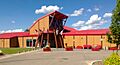
The Allan & Jean Millar Centre has a swimming area, a fieldhouse, and a fitness center. It also has an indoor playground for kids. You can rent rooms for meetings or classes. The swimming area has a main pool, a kids' pool, a lazy river, a water slide, a hot tub, and a steam room. The fieldhouse has a sports area, a track, and courts for racquetball and squash. The fitness center has equipment for cardio and weight training. It also has a studio for fitness classes. This center offers many programs like lessons and personal training.
Festival Park is a large outdoor park near downtown. It has a pond where you can fish. In winter, the pond is cleared for ice skating. The park also has trails, sports fields, playgrounds, and picnic areas. There is an off-leash dog park too. A fun attraction is the river slide, with two artificial creeks for tubing. In 2012, a splash park with 19 water features opened in Festival Park. The park used to be called Rotary Park. Its name changed in 2023 due to new rules from Rotary International.
The town also has several bike trails. There is even a bike park designed by professionals.
The Forest Interpretive Centre has a museum with videos and displays. It shows how the forestry industry is important to Whitecourt's history. The center also has meeting rooms. It is home to the local chamber of commerce and a tourist information center. Town council meetings are also held here. The Heritage Park, connected to the center, has old vehicles and farm equipment. It also has a barn and a walking trail.
Sports in Whitecourt
| Club | League | Sport | Venue | Years Active | League championships | Provincial championships |
|---|---|---|---|---|---|---|
| Whitecourt Wolverines |
|
Ice hockey | JDA Place |
|
|
|
| Whitecourt Wolverines |
|
Ice hockey | JDA Place |
|
|
|

Travis Roche and Rocky Thompson are hockey players from Whitecourt. Travis Roche played 60 games in the National Hockey League (NHL). He played for the Minnesota Wild and Phoenix Coyotes. He also played for Team Canada in the Spengler Cup, winning gold in 2012. Rocky Thompson played 25 games in the NHL for the Calgary Flames and Florida Panthers. He was also an assistant coach for the Edmonton Oilers.
Normand Lacombe is the strength and conditioning coach for the Whitecourt Wolverines of the Alberta Junior Hockey League (AJHL). He used to be the head coach of the earlier Wolverines team. Lacombe played 319 games in the NHL. He played for the Buffalo Sabres, Edmonton Oilers, and Philadelphia Flyers. He won the Stanley Cup with the Oilers in 1988.
Getting Around Whitecourt
Travel by Air
The Whitecourt Airport offers full air service. It is located west of Whitecourt, about 5 kilometers (3.1 mi) from Highway 43. It is Alberta's ninth busiest airport. Up to 32,000 aircraft use the airport each year. The runway is 5,800 feet (1,768 m) long and 100 feet (30 m) wide. It can handle large jets like the 737. Many companies offer scheduled charter flights from this airport.
Travel by Bus
Red Arrow and Northern Express bus companies offer trips. You can travel to Edmonton and Grande Prairie from Whitecourt.
Travel by Train
The CN Sangudo Subdivision provides train service. It runs through Whitecourt from Edmonton. It goes to many gas plants south of Fox Creek. The Millar Western Sawmill / Pulp Mill and the Alberta Newsprint Company Pulp & Paper Mill both use the train for shipping.
Travel by Road
Two main highways serve the Town of Whitecourt. Highway 43 is a divided highway. It is part of the CANAMEX Corridor. This highway connects Whitecourt to Edmonton in the southeast. It also connects to Grande Prairie in the northwest.
Highway 32 gives Whitecourt a direct link to the Yellowhead Highway (Highway 16) to the south. This highway connects the town to Edson and Hinton. Another part of Highway 32 starts about 6 kilometers (3.7 mi) northwest of town. It links Highway 43 to Swan Hills and Slave Lake.
Many local roads connect Whitecourt to the nearby rural areas in Woodlands County. In the McLeod River valley, Govenlock Road leads to two country roads. These are West Mountain Road and Tower Road. They provide access to homes and farms to the south.
In the Athabasca River valley, Flats Road (Township Road 600) leaves the town from its northern edge. This road serves many farms to the east.
On the Hilltop, 41 Avenue (Township Road 594A) was the original highway into Whitecourt. This road leaves the town going east towards the Hamlet of Blue Ridge. People often call this road Blue Ridge Road.
Schools in Whitecourt

|
|
Whitecourt's Media
Newspapers
Whitecourt has two news sources. The Whitecourt Star is owned by Postmedia Network. It became an online-only newspaper in 2023. The Whitecourt Press is an independent weekly newspaper. The monthly Community Advisor stopped publishing in 2018.
Radio Stations
Two FM radio stations broadcast from Whitecourt:
- Boom 96.7 (FM 96.7, CFXW-FM) plays classic hits. It is owned by Stingray Radio.
- XM 105 FM (FM 105.3, CIXM-FM) plays country radio music. It is owned by Pattison Media.
The CKUA Radio Network also has a repeater in Whitecourt at FM 107.1.
Sister Cities
Whitecourt has a sister city relationship with Yūbetsu, Hokkaido, Japan. This partnership started in 1998. High school students from Hilltop High School have visited Japan as part of this program. They stayed with Japanese families and traveled to Tokyo.
Images for kids
-
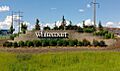
Whitecourt's entrance sign on Highway 43
-
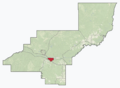
Location in Woodlands County
-

Whitecourt's official logo
-
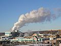
Millar Western sawmill and pulp mill
-
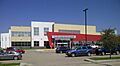
The Allan & Jean Millar Centre
-
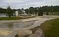
The Whitecourt River Slides overlooking the pond and fountain in Festival Park
-
Whitecourt's Forest Interpretive Centre
-
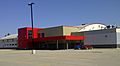
JDA Place, home of the Whitecourt Wolverines
-
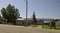
Hilltop High School main entrance
