
Columbia Icefield facts for kids

The Columbia Icefield is the biggest ice field in North America's Rocky Mountains. It sits high up in the Canadian Rockies, right on the Continental Divide. This means it's partly in Banff National Park and partly in Jasper National Park, crossing the border between British Columbia and Alberta, Canada. It's huge, covering about 325 square kilometers (125 square miles). The ice is very deep, from 100 meters (330 feet) to 365 meters (1,200 feet) thick! It also gets a lot of snow, up to 7 meters (23 feet) each year.
Contents
How the Icefield Formed
The Columbia Icefield was created a very long time ago during major ice ages. The first big ice advance happened between 238,000 and 126,000 BCE. Later, another huge advance occurred between 18,000 and 9,000 BCE. The last major time the icefield grew was during the Little Ice Age, which lasted from about 1200 to 1900 AD. Around 1800, the Athabasca Glacier (one of the icefield's glaciers) was at its biggest. It then started to shrink, grew a little again until 1840, and has been shrinking ever since.
Exploring the Icefield
The Columbia Icefield was one of the last big places in western Canada to be explored by Europeans. This was because it was so remote and the weather was very harsh.
In 1827, a Scottish botanist named David Douglas was exploring nearby. He climbed a mountain and thought it was incredibly tall. Later, in 1884, a geology professor named Arthur Philemon Coleman searched for Douglas's giant peak. He didn't find it, but he did discover the route that is now the famous Icefield Parkway.
In July 1898, British explorer J. Norman Collie and his friends set out to find Douglas's peaks. On August 18, Collie and Herman Wooley climbed Mount Athabasca. From the top, they saw an amazing sight: a massive ice field stretching out in every direction! Collie wrote that it was a "new world" with "vast ice-field probably never before seen by the human eye."

After World War I, more amazing climbing feats happened. In 1923, American climbers and an Austrian guide climbed several difficult peaks, including North Twin Peak, Mount Columbia, and Mount Saskatchewan, all in just five days! The next year, another team climbed both the North Twin Peak and the South Twin Peak in 24 hours.
In 1927, A. J. Ostheimer explored the area for 63 days. He walked over 1,000 kilometers (620 miles) and climbed thirty peaks! Twenty-five of these were first ascents, meaning no one had climbed them before.
In 1932, three men, Cliff White, Joe Weiss, and Russell Bennet, made an incredible ski trip from Jasper to Banff, covering about 500 kilometers (310 miles). When they reached the Columbia Icefield, they skied down for almost 50 kilometers (30 miles)! This was the longest continuous ski run in Canadian history at the time. Their adventure helped make the Canadian Rockies famous around the world. Today, many adventurers still come to the Columbia Icefield to follow in the footsteps of these early explorers.
Glaciers of the Icefield
The Columbia Icefield feeds six large glaciers:
- Athabasca Glacier
- Castleguard Glacier
- Columbia Glacier
- Dome Glacier
- Stutfield Glacier
- Saskatchewan Glacier
You can see parts of the Columbia Icefield and its glaciers from the Icefields Parkway.
The Athabasca River and the North Saskatchewan River start in the Columbia Icefield. Also, some of the water that feeds the Columbia River begins here. This icefield is special because it sits on a "triple Continental Divide." This means water from the icefield flows in three different directions:
- North to the Arctic Ocean
- East to Hudson Bay (and then to the North Atlantic Ocean)
- South and West to the Pacific Ocean
Mountains Around the Icefield


Some of the tallest mountains in the Canadian Rockies are found around the edges of the Columbia Icefield:
- Mount Alberta (3,619 meters / 11,873 feet)
- Mount Andromeda (3,450 meters / 11,319 feet)
- Mount Athabasca (3,491 meters / 11,453 feet)
- Mount Bryce (3,507 meters / 11,506 feet)
- Mount Castleguard (3,090 meters / 10,138 feet)
- Mount Columbia (3,747 meters / 12,293 feet)
- Mount King Edward (3,490 meters / 11,450 feet)
- Mount Kitchener (3,505 meters / 11,499 feet)
- North Twin Peak (3,684 meters / 12,087 feet)
- South Twin Peak (3,566 meters / 11,699 feet)
- Snow Dome (3,456 meters / 11,339 feet)
- Stutfield Peak (3,450 meters / 11,319 feet)
Images for kids
-

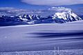
Snow Dome and the Columbia Icefield
-
Columbia Icefield; Mount Bryce on the right
-
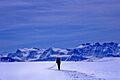
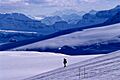
Skiing on the Columbia Icefield
-
Peaks to the West of the Icefield


See also
 In Spanish: Campo de hielo Columbia para niños
