Stutfield Peak facts for kids
Quick facts for kids Stutfield Peak |
|
|---|---|

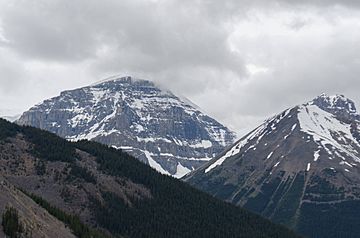
Stutfield's East Peak seen from the Skywalk area
|
|
| Highest point | |
| Elevation | 3,450 m (11,320 ft) |
| Prominence | 290 m (950 ft) |
| Listing | Mountains of Alberta |
| Geography | |
| Location | Alberta, Canada |
| Parent range | Winston Churchill Range |
| Topo map | NTS 83C/03 |
| Climbing | |
| First ascent | 1927 by Alfred J. Ostheimer, guided by Hans Fuhrer |
| Easiest route | rock/snow climb |
Stutfield Peak is a tall mountain located in Jasper National Park, Alberta, Canada. It stands proudly at the northern edge of the huge Columbia Icefield. This peak is about 6 kilometers (3.7 miles) northwest of Mount Kitchener. It is part of the Winston Churchill Range within the amazing Canadian Rockies.
Stutfield Peak actually has two main tops, or "summits." These are called Stutfield East and Stutfield West. Because of these two tops, people sometimes call the mountain The Stutfields. The West peak is a bit taller than the East peak, by about 50 meters (164 feet).
Naming Stutfield Peak
In 1899, a famous mountain climber named J. Norman Collie gave the mountain its name. He named it after his friend, Hugh Stutfield. Hugh Stutfield was also a climber who explored the Canadian Rockies with Collie.
The Stutfield Glacier
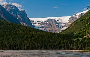
There is also a large ice mass called the Stutfield Glacier. This glacier was also named after Hugh Stutfield. It flows southeast from the peak and is part of the big Columbia Icefield.
Exploring the Climate of Stutfield Peak
The area around Stutfield Peak has a subarctic climate. This means it has very cold and snowy winters. The summers are usually mild. Temperatures can drop below -20 degrees Celsius (-4 degrees Fahrenheit). With the wind, it can feel even colder, sometimes below -30 degrees Celsius (-22 degrees Fahrenheit)!
 | Janet Taylor Pickett |
 | Synthia Saint James |
 | Howardena Pindell |
 | Faith Ringgold |


