
Banff National Park facts for kids
Quick facts for kids Banff National Park |
|
|---|---|
|
IUCN Category II (National Park)
|
|

Moraine Lake, and the Valley of the Ten Peaks
|
|
| Location | Alberta |
| Nearest town | Canmore, Alberta |
| Area | 6,641 km2 (2,564 sq mi) |
| Established | 1885 |
| Visitors | 3,609,639 (in 2014/15) |
| Governing body | Parks Canada |
Banff National Park (French: Parc national Banff) is Canada's oldest national park, created in 1885. It's located in Alberta's Rocky Mountains, about 110 to 180 kilometers west of Calgary. Banff covers a huge area of 6,641 square kilometers. This land is full of mountains, glaciers, ice fields, thick coniferous forests, and high alpine areas.
The Icefields Parkway is a famous road that starts at Lake Louise. It connects Banff to Jasper National Park in the north. To the west, Banff is next to provincial forests and Yoho National Park. Kootenay National Park is to the south, and Kananaskis Country is to the southeast. The main town in the park is Banff, which sits in the Bow River valley.

The Canadian Pacific Railway played a big role in Banff's early days. They built famous hotels like the Banff Springs Hotel and Chateau Lake Louise. They also brought many tourists by advertising the park widely. In the early 1900s, roads were built in Banff. These projects sometimes involved people working on large public works, including during the Great Depression.
Since the 1960s, places to stay in the park have been open all year. The number of visitors to Banff grew to over 5 million in the 1990s. Millions more people drive through the park on the Trans-Canada Highway. With so many visitors, the park's natural environment has faced challenges. In the mid-1990s, Parks Canada started a study to help protect the park's nature. They created new rules to keep the ecosystem healthy.
Banff National Park has a subarctic climate. It has three main natural zones: montane, subalpine, and alpine. Forests at lower elevations are mostly Lodgepole pine trees. Higher up, below the treeline, you'll find Engelmann spruce. Above the treeline, it's mostly rocks and ice.
Many animals live here, like grizzly bears, cougars, wolverines, elk, bighorn sheep, and moose. Hundreds of bird species also call Banff home. There are also some reptiles and amphibians. The mountains here are made of sedimentary rock. They were pushed up between 80 and 55 million years ago. In the past few million years, glaciers covered most of the park. Today, glaciers are only on mountain slopes, but they include the huge Columbia Icefield. Water and ice have shaped the mountains into what they look like today.
Contents
Exploring Banff National Park

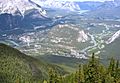
Banff National Park is in the Rocky Mountains. It's on Alberta's western border with British Columbia. The town of Banff is about 128 kilometers west of Calgary by road. It's also about 401 kilometers southwest of Edmonton.
Jasper National Park is to the north of Banff. Yoho National Park is to the west, and Kootenay National Park is to the south. Kananaskis Country is located to the south and east.
The Trans-Canada Highway goes right through Banff National Park. It passes through the towns of Banff and Lake Louise. Then it continues into Yoho National Park in British Columbia. The town of Banff is the main hub in the park. The village of Lake Louise is where the Trans-Canada Highway meets the Icefields Parkway.
Banff Town: The Heart of the Park
The town of Banff was started in 1885. It's the main center for businesses and cultural events in Banff National Park. Banff has many interesting places to visit. These include the Banff Centre, the Whyte Museum, and the Buffalo Nations Luxton Museum. You can also see the Cave and Basin National Historic Site and several art galleries.
Banff has hosted many yearly events throughout its history. The Banff Mountain Film Festival has been held here since 1976. In 1990, Banff officially became a town in Alberta. However, it still follows rules from the National Parks Act. This means the federal government helps with planning and building. In 2014, Banff had about 9,386 people living there. The Bow River flows through the town, and Bow Falls are just outside.
Lake Louise: A Famous View

Lake Louise is a small village about 54 kilometers northwest of the town of Banff. It's famous for the beautiful Chateau Lake Louise hotel. This hotel sits right on the edge of Lake Louise.
About 15 kilometers from Lake Louise is Moraine Lake. This lake offers amazing views of the Valley of the Ten Peaks. This stunning scene was even on the back of the Canadian $20 banknote from 1969 to 1979! The Lake Louise Mountain Resort is also close to the village. Lake Louise is one of the most visited lakes in the world. It's surrounded by mountains, with the Mount Victoria Glacier to the southwest.
Icefields Parkway: A Scenic Drive
The Icefields Parkway is a 230-kilometer-long road. It connects Lake Louise to Jasper, Alberta. The Parkway starts at Lake Louise and goes north up the Bow Valley. It passes by Hector Lake, which is the biggest natural lake in the park. Other beautiful lakes along the parkway include Bow Lake and Peyto Lake.
The Parkway then crosses Bow Summit, which is 2088 meters high. This is the highest point a public road crosses in Canada! It then follows the Mistaya River to Saskatchewan Crossing. Here, it meets the Howse and North Saskatchewan River.
The North Saskatchewan River flows east from Saskatchewan Crossing. It leaves Banff and goes into an area known as David Thompson Country. The David Thompson Highway follows this river. It passes the man-made Abraham Lake. North of Saskatchewan Crossing, the Icefields Parkway follows the North Saskatchewan River up to the Columbia Icefield. The Parkway enters Jasper National Park at Sunwapta Pass, which is 2035 meters high.
How Banff's Mountains Were Formed


The Canadian Rockies have many mountain ranges that run from northwest to southeast. Banff National Park has two main mountain ranges. The western edge of the park follows the top of the Main Ranges. This line is also the continental divide, which separates rivers flowing to different oceans.
The Main Ranges in Banff include the Waputik, Bow, and Blue Ranges. The high peaks west of Lake Louise are part of the Bow Range. The eastern edge of the park includes the Front Ranges. These include the Palliser, Sawback, and Sundance Ranges. The town of Banff is located in the Front Ranges. The tallest mountain completely inside the park is Mount Forbes at 3612 meters. Mount Assiniboine, on the border of Banff and Mount Assiniboine Provincial Park, is slightly taller at 3618 meters.
The Canadian Rockies are made of sedimentary rock. This includes shale, sandstone, dolomite, and limestone. Most of the rocks in Banff are from the Precambrian to the Jurassic periods (600 to 145 million years ago). However, some younger rocks can be found near the east entrance. These rocks were laid down in shallow seas long ago. They were then pushed east during a mountain-building event called the Laramide orogeny. Mountain building in Banff National Park finished about 55 million years ago.
The Canadian Rockies might have been as tall as 8000 meters about 70 million years ago. After the mountains formed, erosion started to carve them into their rugged shapes. Water caused some erosion, but it sped up a lot during the Quaternary glaciation 2.5 million years ago. Glaciers have shaped Banff's landscape a lot. You can see many classic glacier features like cirques (bowl-shaped hollows), arêtes (sharp ridges), hanging valleys, moraines (piles of rock left by glaciers), and U-shaped valleys.
Many mountain ranges here run from northwest to southeast. The layers of rock often tilt down to the west. This creates mountains with steeper east and north faces. Rivers and old glacial valleys often follow the weaker rock layers. A good example is Mount Rundle near the town of Banff. Castle Mountain is made of several rock layers. The top is hard dolomite, below that are softer shales, and the lowest cliffs are limestone.
Glaciers and Icefields: Nature's Sculptors
Banff National Park has many large glaciers and icefields. You can see 100 of them from the Icefields Parkway. Small cirque glaciers are common in the Main Ranges. They sit in hollows on the sides of many mountains.
Like most glaciers worldwide, the glaciers in Banff are shrinking. Peyto Glacier has been studied for a long time, since the 1970s. However, most glaciers in the Canadian Rockies have only been studied closely since the late 1990s. Scientists are now researching the glaciers more to understand how shrinking ice might affect water supplies.
It's estimated that 150 glaciers disappeared in the Canadian Rockies between 1920 and 1985. Another 150 disappeared between 1985 and 2005. This shows that glaciers are melting and vanishing faster. In Banff National Park alone, 29 glaciers disappeared between 1985 and 2005. The total area covered by glaciers dropped from 625 to 500 square kilometers in that time.
The biggest glaciated areas are the Waputik and Wapta Icefields. Both are on the border of Banff and Yoho National Parks. The Wapta Icefield covers about 80 square kilometers. Glaciers flowing from Wapta Icefield into Banff include Peyto, Bow, and Vulture Glaciers. Bow Glacier shrank by about 1100 meters between 1850 and 1953. Since then, it has shrunk even more, leaving a new lake where its end used to be. Peyto Glacier has lost 70 percent of its size since records began. It has shrunk by about 2000 meters since 1880. This glacier might disappear completely in the next 30 to 40 years.

The Columbia Icefield is at the northern end of Banff. It sits on the border of Banff and Jasper National Parks and extends into British Columbia. Snow Dome, in the Columbia Icefield, is a special place. Water from its glaciers flows to the Atlantic, Pacific, and Arctic Oceans! Saskatchewan Glacier is about 13 kilometers long and covers 30 square kilometers. It's the main glacier from the Columbia Icefield that flows into Banff National Park. Between 1893 and 1953, Saskatchewan Glacier shrank by 1364 meters. From 1948 to 1953, it was shrinking by about 55 meters each year. Overall, the glaciers in the Canadian Rockies lost 25 percent of their mass during the 20th century.
Wildlife and Nature in Banff
Ecoregions: Different Natural Zones

Banff National Park has three main natural zones, called ecoregions: montane, subalpine, and alpine. The subalpine zone is mostly thick forest and makes up 53 percent of Banff's area. About 27 percent of the park is above the tree line, in the alpine zone. The tree line in Banff is around 2300 meters high. Above this, you'll find open meadows and some areas covered by glaciers.
A small part (3 percent) of the park is in the montane zone, at lower elevations. Lodgepole pine forests are common in the montane region of Banff. You'll also see Engelmann spruce, willow, aspen, and sometimes Rocky Mountain Douglas-fir and Douglas maple. Engelmann spruce trees are more common in the subalpine areas of Banff. Here, you'll also find some lodgepole pine and subalpine fir. The montane areas in the Bow Valley are often where wildlife prefers to live. These areas have seen a lot of human development over the years.
Animals of Banff National Park

The park has 56 different types of mammals. Grizzly bears and black bears live in the forested areas. Other main predators include cougars, lynx, wolverines, red foxes, weasels, river otters, coyotes, and wolfes.
Elk, mule deer, and white-tailed deer are common in the park's valleys. You can often see them around the town of Banff. Moose are harder to spot. They usually stay in wet areas and near streams. In the high alpine regions, you'll find mountain goats, bighorn sheep, marmots, and pikas. Smaller mammals like beavers, porcupines, squirrels, chipmunks, snowshoe hares, and Columbian ground squirrels are also often seen. Caribou were the rarest large mammals in the park. Sadly, an avalanche in 2009 might have killed the last five caribou in the park.
Because of the cold winters, the park has few reptile and amphibian species. Only one type of toad, three types of frogs, one salamander, and two types of snakes have been found. At least 280 bird species live in Banff. These include predatory birds like bald and golden eagles, red-tailed hawks, ospreys, and merlins.
Commonly seen birds at lower elevations include the Canada jay, American three-toed woodpecker, mountain bluebird, Clark's nutcracker, mountain chickadee, and pipit. The white-tailed ptarmigan is a ground bird often seen in the alpine zones. Rivers and lakes are home to over a hundred different bird species. These include loons, herons, and mallards, which spend their summers in the park.
Endangered species in Banff include the Banff Springs snail (Physella johnsoni). This tiny snail is only found in the hot springs of Banff. The Woodland caribou are also an endangered species here.
Mountain Pine Beetles: A Forest Challenge
Mountain pine beetles have caused several large outbreaks in Banff National Park. These beetles eat the inner bark of mature lodgepole pines. Alberta's first known outbreak happened in 1940. It affected 43 square kilometers of forest in Banff. A second big outbreak happened in the late 1970s and early 1980s. It affected Banff and the surrounding Rocky Mountains.
Images for kids
-
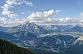
View from the summit of Sulphur Mountain, showing Banff and the surrounding areas
-
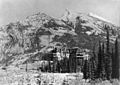
Banff Springs Hotel, 1902
-
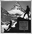
Canadian Pacific Railway advertising brochure, highlighting Mount Assiniboine and Banff scenery, c. 1917
-
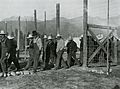
Castle Mountain internment camp, 1915
-
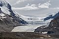
the Columbia Icefield's Athabasca Glacier at the northern end of Banff
-
Parker Ridge, near the Columbia Icefield
-
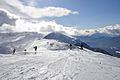
Skiing at Lake Louise
-
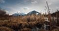
Mount Rundle and Sulphur Mountain as seen from the reeds along the shore of one of the Vermillion Lakes in Banff National Park, Alberta, Canada.
-
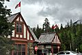
Entry station for Banff National Park
-
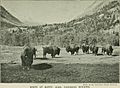
Historical image of bison in Banff in 1900s
-

Bear-proof garbage can at Lake Louise
-
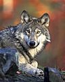
Gray wolf
-
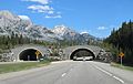
Wildlife overpass
-
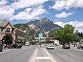
Banff townsite
-
Bow River winding through Banff town


_(14780658104).jpg)


See also
 In Spanish: Parque nacional Banff para niños
