Waputik Icefield facts for kids
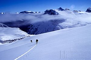
The Waputik Icefield is a large area of ice and snow found high up in the Canadian Rocky Mountains. It sits right on the Continental divide, which is like a giant line that separates rivers flowing to different oceans. This amazing icefield is located in both British Columbia and Alberta provinces. It forms on the highest parts of the Waputik Range.
This icefield is part of two famous national parks: Banff and Yoho National Park. Many smaller glaciers flow out from the main icefield. Water from the melting icefield feeds many lakes, streams, and rivers. These include Hector Lake, the Bow River, the Kicking Horse River, and the Yoho River. Water from one of its glaciers, the Daly Glacier, even helps create the beautiful Takakkaw Falls.
The Waputik Icefield covers about 40 square kilometers (15 square miles). It is located about 20 kilometers (12 miles) northwest of Lake Louise. You can find it on the west side of the famous Icefields Parkway.
Adventurers can easily reach this icefield in both summer and winter. In winter, people enjoy ski trips across the icefield. In summer, they go on glacier hiking trips. Many people combine exploring the Waputik Icefield with a trip across the Wapta Icefield, which is just to the north.
Glaciers of the Icefield
The Waputik Icefield is home to several important glaciers. These large rivers of ice slowly move down the mountains. Here are some of the glaciers that are part of this icefield:
- Waputik Glacier
- Diableret Glacier
- Glacier des Poilus
- Emerald Glacier
- Bath Glacier
- Niles Glacier
- Balfour Glacier
- Daly Glacier
Huts for Explorers
The Alpine Club of Canada manages two special huts near the Waputik Icefield. These huts offer shelter and a place to rest for mountaineers and hikers. They are great starting points for exploring the icefield.
- Scott Duncan Hut
- Balfour Hut
 | George Robert Carruthers |
 | Patricia Bath |
 | Jan Ernst Matzeliger |
 | Alexander Miles |


