
Bow River facts for kids
Quick facts for kids Bow River |
|
|---|---|

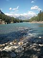
The Bow River near Banff
|
|

Map of the Bow River
|
|
| Country | Canada |
| Province | Alberta |
| Physical characteristics | |
| Main source | Bow Lake 1,960 m (6,430 ft) 51°39′03″N 116°25′12″W / 51.65083°N 116.42000°W |
| River mouth | South Saskatchewan River 700 m (2,300 ft) 49°55′42″N 111°41′12″W / 49.92833°N 111.68667°W |
| Length | 587 km (365 mi) |
| Basin features | |
| Basin size | 26,200 km2 (10,100 sq mi) |
The Bow River is a major river in Alberta, Canada. It starts high up in the Rocky Mountains. From there, it flows through foothills and wide-open prairies. Eventually, the Bow River joins the Oldman River to form the South Saskatchewan River. All these waters then travel through the Nelson River to reach Hudson Bay.
The Bow River flows right through the big city of Calgary. In Calgary, it meets another river called the Elbow River. The river's name, "Bow," comes from the reeds that grew along its banks. Long ago, First Nations people used these reeds to make bows for hunting. In the Blackfoot language, the river is called Makhabn, which means "river where bow reeds grow."
This river is super important for water. It provides drinking water and water for irrigation (watering crops). Between 1910 and 1960, many changes were made to the Bow River. Dams were built to create hydroelectric power, mostly for Calgary. These changes greatly affected how the river flowed and the animals living in it.
Contents
Journey of the Bow River


The Bow River starts from the Bow Glacier. This glacier is part of the Wapta Icefield. The water from the glacier flows into Bow Lake in the Canadian Rockies.
From Bow Lake, the river flows south to the village of Lake Louise. Then it turns east. It passes through the towns of Banff and Canmore. Further downstream, the Ghost Lake reservoir is formed.
The Bow River continues east to the city of Calgary. After Calgary, it joins the Oldman River near Grassy Lake. This meeting point forms the South Saskatchewan River. The water eventually reaches Hudson Bay through other rivers and Lake Winnipeg.
Many towns and cities are located along the Bow River. These include Lake Louise, Banff, Canmore, Cochrane, Calgary, and Arrowwood. You can also find the beautiful Bow Falls near Banff. The Bow River is about 587 km (365 mi) long. Its drainage area, which is the land that collects water for the river, covers about 26,200 km2 (10,100 sq mi).
River's Past and People
First Peoples and Early Settlers
David Thompson, a fur trader, was one of the first Europeans to see the Bow River. He camped there with Piikani people in 1787–88. But long before that, First Nations people had lived in the Bow River area for thousands of years. These groups included the Nakoda, Tsuu Tʼina, and the Blackfoot Confederacy. The Blackfoot Confederacy includes the Kainai, Piikanai, and Siksika peoples.
First Nations used the river valleys for hunting buffalo. They would guide buffalo herds over cliffs or into valleys. This made it easier to hunt them with bows and arrows. The Nakoda people were known for fishing in the river regularly. Other groups mostly hunted buffalo, even though fish were plentiful in summer.
The river's water attracted many animals for hunting. Women gathered roots, nuts, and berries for food. The river also provided firewood and shelter. This made the Bow River a popular place for First Nations to camp during winter. The river was also a natural boundary. Two main crossing points became important gathering places. Here, First Nations traded goods and held celebrations. One of these places, Blackfoot Crossing, is now part of the Siksika reserve.
After Thompson's trip, fur traders came to the Bow River region. But the river wasn't a major part of the fur trade. The arrival of the whisky trade in the 1870s caused problems for First Nations. To stop this, the North-West Mounted Police (now the RCMP) built Fort Calgary in 1875. This fort was located where the Elbow River meets the Bow.
As more settlers arrived and railways were built, the government wanted to make agreements with First Nations. These agreements were called treaties. In 1877, the Nakoda, Tsuu Tʼina, Kainai, Piikanai, and Siksika signed Treaty 7 at Blackfoot Crossing. They agreed to live on specific lands called reserves. In return, they gave up their land rights outside these reserves. The reserves for the Nakoda, Tsuu Tʼina, and Siksika were set up along the Bow River.
Building Dams for Power
After 1900, Calgary grew very fast. Business leaders wanted to build dams to create cheaper hydroelectric power. In 1910, the Calgary Power Company was formed. They started building Alberta's first big hydroelectric plant, Horseshoe Dam. This was on land bought from the Nakoda people.
The Bow River's flow changes a lot depending on winter snow. Calgary Power didn't have good information on the river's flow. So, they couldn't always produce enough electricity in winter. To fix this, they built another power plant and reservoir on a river that flows into the Bow, the Kananaskis River. A reservoir was also created in Banff National Park at Lake Minnewanka in 1912.

Even with these additions, Calgary Power still struggled in winter. So, in the 1920s, they planned more projects to control the Bow River. The Ghost Dam was built in 1929. A big project on the Spray River (another tributary) finished in 1951. In 1954, the Bearspaw Dam was built near Calgary to help control floods. It also had a power station. During World War II, more power was needed. Another hydroelectric project was built in Banff National Park on the Cascade River.
Between 1910 and 1960, the Bow River changed a lot. It was engineered to control its water flow and make electricity. This meant that big summer floods in Calgary became a thing of the past. Water was stored in reservoirs during spring and summer. This allowed for steady power generation in fall and winter. For example, the river's flow in January almost doubled between the 1920s and 1950s. Some parts of the river even turned into lakes. These changes also affected the environment. Some fish species, like brown trout, thrived, while others almost disappeared.
Protecting the River's Environment

By the 1950s, the south bank of the Bow River in Calgary was a run-down business area. A group called the Calgary Local Council of Women wanted to turn this area into a park system. The Calgary City Council agreed in 1955. But not much happened for a while.
Later, the city and the Canadian Pacific Railway thought about moving the railway along the river. This would create a parkway. But the Local Council of Women reminded the city of its promise for a river park. Eventually, the railway plan failed. More people started supporting the idea of a riverfront park system.
People who wanted parks saw the Bow River as Calgary's natural space. It was something to protect and for everyone to enjoy. The city eventually created a large plan for the Bow River's park system. Today, this pathway is a very important part of Calgary's identity.
In 1989, a toxic "blob" was found in the Bow River. It came from an old wood-preserving plant. This "blob" released harmful chemicals that spread for over 250 kilometres (160 mi) downstream. This caused a lot of worry, especially since many Calgarians used the river for fun.

Because of this, Alberta's leader, Ralph Klein, created the Bow River Water Quality Council. This group included people from First Nations, farming, and cities. They worked to raise awareness about the river's water quality. They also tried to improve it by finding facts and helping different groups work together. Groups like Ducks Unlimited and the Bow Waters Canoe Club cared about the river's environment. They wanted to keep the river healthy for people to use and enjoy.
Over time, the council's views changed. By 1994, their reports stressed the importance of the river's entire ecosystem. They realized that keeping the whole system balanced was key to good water quality. In the mid-1990s, people started treating the upper Bow River with a biocentric approach. This means they focused on the river's natural value, not just how humans used it. Maintaining the ecosystems in Banff National Park became more important than just human enjoyment.
2013 Floods
In June 2013, southern Alberta had huge amounts of rain. This caused terrible floods along the Bow, Elbow, Highwood, and Oldman rivers. Many towns and cities declared emergencies. Water levels rose very quickly, and many communities had to evacuate.
Banff National Park
Creating a National Park
In 1887, the Canadian government created Rocky Mountain Park. This park later became Banff National Park. It was Canada's first national park and included the Bow River. Over time, the park grew to include the Bow Glacier, where the Bow River begins.
Making Banff a national park changed how people saw the Bow River. People started to appreciate its beauty, not just its use for industry or farming. The Canadian Pacific Railway, which helped develop Banff, understood this. When they built a new luxury hotel in Banff in 1886–87, the vice-president, William Van Horne, changed the plans. He made sure hotel guests would have a great view of the Bow River. Many old and new postcards from Banff show the Bow River prominently.
Keeping Banff Sustainable

From the 1920s onwards, the National Parks of Canada focused on making money from tourism. This meant building new highways and creating reservoirs to store water for the growing town of Banff. So, the Bow River was seen for its beauty and its practical uses.
By the 1950s, Banff was dumping its raw sewage into the Bow River. The cold, fast-flowing water was good at cleaning itself naturally. Tourists and residents often didn't know the river was being used as a sewage treatment system.
As Banff grew, more sewage went into the river. This started to bother people. Pouring raw sewage into a main attraction of the park polluted the river and Banff's image. There was also a worry that relying on the river as a sewer would stop Banff from growing or harm public health. By the 1960s, Banff built a modern sewage plant. They stopped releasing untreated water into the Bow. The river's beauty became a top priority for development within the National Park.
Fun on the Bow River
.jpg)
The Bow River is home to lots of wildlife. It also offers many chances for fun activities like fishing and boating. Fishermen, both fly fishermen and spinner fishermen, enjoy the river all year round. Serious anglers from all over the world come to the Bow River. They love its healthy populations of brown trout and rainbow trout. These trout grow very well in the Bow River. A 4 to 5-year-old trout can be around 53 centimetres (21 in) long! The river has many fish this size or even bigger. Most fishing happens south of Calgary, where the water treatment sites release water into the river. This area has more nutrients and more fish.
People use three main types of boats on the river: inflatable boats, Jon boats, and canoes. There are several places to launch boats, like Graves Landing and McKinnon Flats.
The Bow River pathway runs along both sides of the river in Calgary. It's a great place for cycling, hiking, jogging, rollerblading, and skateboarding.
Calgary's Harvie Passage
In 1904, the Bow River Weir was built near downtown Calgary. A weir is like a small dam that diverts water. This weir was made to send water into the Western Irrigation District for farming. But it created a dangerous, swirling wave right after it. Because rafting, canoeing, and kayaking are popular on the Bow River, this spot caused many accidents and deaths. Also, fish couldn't pass through the weir. This trapped them, and many pelicans gathered there to eat the trapped fish.
To fix this dangerous wave, construction began in 2007 on the Bow River Weir paddle around, called the Harvie Passage. This project aimed to spread the wave over several smaller rapids. It still allowed water to go to the irrigation district. The Harvie Passage cost 18 million dollars and was finished in spring 2012.
However, in June 2013, just a year after it opened, Calgary was hit by a huge flood. All the work on the Harvie Passage was destroyed. Since then, the passage has been closed to the public. Rebuilding it to its original design would cost about $23.4 million. It is expected to remain closed until at least 2018.
River Life
An invasive species of algae called Didymosphenia geminata, or "rock snot," is a concern. It threatens the populations of brown trout in the river.
Rivers that Join the Bow
|
|
Many lakes are found in the Bow Valley. Some are natural, formed by glaciers. Others are man-made reservoirs. These include Bow Lake, Hector Lake, Vermilion Lakes, Gap Lake, Lac des Arcs, and Ghost Lake.
Gallery
-
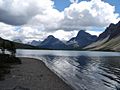
Bow River originates in Bow Lake.
-
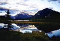
Vermilion Lakes formed along the Bow River
-
Lac des Arcs formed along Bow River
-
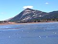
Hoodoos above the Bow River.
-
Ghost Lake in Bow Valley
-
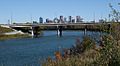
Crowchild Trail crossing the river in Calgary, downtown in background
-
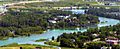
Bow River with Calgary Zoo


Images for kids
-
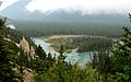
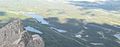
Mountains around Banff, with Spray River flowing north to the Bow River at Banff (a small cloud obscures Banff itself)
-
Bow River


See also
 In Spanish: Río Bow para niños
