
Elbow River facts for kids
Quick facts for kids Elbow River |
|
|---|---|

Elbow River in Calgary
|
|
| Country | Canada |
| Province | Alberta |
| Physical characteristics | |
| Main source | Elbow Lake, Elbow Pass, Kananaskis Improvement District 2,100 m (6,900 ft) 50°38′32″N 115°00′22″W / 50.64219°N 115.00604°W |
| River mouth | Bow River 1,040 m (3,410 ft) 51°02′43″N 114°02′29″W / 51.04519°N 114.04126°W |
| Length | 120 km (75 mi) |
| Basin features | |
| Basin size | +1,200 km2 (460 sq mi) |
The Elbow River is a river in southern Alberta, Canada. It starts in the Canadian Rockies mountains. Then, it flows all the way to the city of Calgary. In Calgary, it joins another river called the Bow River.
The Elbow River is a fun place for many outdoor activities. People love to go canoeing, rafting, camping, and hiking along its banks. You can find cool spots like Allen Bill Pond, Forgetmenot Pond, and Elbow Falls along the river. Some parts of the river are special for fishing. You might need to release the fish you catch back into the water.
The amount of water in the Elbow River can change a lot. Sometimes, there is a huge amount of water, which can cause floods. In June 2005, a very big flood happened. So much water flowed that it went over the Glenmore Dam. About 1,500 people living near the river in Calgary had to leave their homes for safety. Another even bigger flood happened on June 20, 2013. This time, tens of thousands of people had to evacuate.
Contents
What happened during the 2013 floods?
.jpg)
In June 2013, the province of Alberta, Canada, had a lot of rain. This heavy rain caused huge floods in many parts of southern Alberta. Rivers like the Bow, Elbow, Highwood, and Oldman overflowed their banks.
On June 20, 2013, many towns and cities in Southern Alberta declared a state of emergency. This means they needed extra help to deal with the rising water. Many communities had to tell their residents to leave their homes because of the danger.
Where does the Elbow River flow?

The Elbow River begins at Elbow Lake. This lake is found in the Elbow-Sheep Wildland Provincial Park in the Canadian Rockies. From there, the river flows through the foothills of the Rocky Mountains. It then reaches the small community of Bragg Creek.
The river goes under Highway 22. It then travels through the rural area of Springbank. It also passes through the Tsuu T'ina Nation 145 Indian reserve, which is west of Calgary.
The Elbow River enters Calgary at a place called the Weaselhead Flats. This area is like a natural wetland. The river then flows into the Glenmore Reservoir. This reservoir is one of the main places Calgary gets its drinking water from. After that, the river flows north through different neighborhoods. It goes under Macleod Trail and past the Calgary Stampede grounds. Finally, it joins the Bow River near the Calgary Zoo.
Long ago, in 1873, a police post called Fort Calgary was built. This fort was placed right where the Bow and Elbow rivers meet. This spot was important for the start of settlement in the Calgary area.
The Elbow River is about 120 kilometres (75 mi) long. It drains an area of more than 1,200 square kilometres (460 sq mi). The river starts high up in the Elbow Pass, at about 2,100 metres (6,900 ft) above sea level. It then drops about 1,060 metres (3,480 ft) in height until it reaches the Bow River, which is at an elevation of 1,040 metres (3,410 ft).
What are the smaller streams that join the Elbow River?
Many smaller streams and creeks flow into the Elbow River, adding to its water. These are called tributaries. Some of them include:
- Little Elbow River
- Canyon Creek
- Iron Creek
- Bragg Creek
- Harris Creek
- Pirmez Creek
- Millburn Creek
- Springbank Creek
- Cullen Creek
- May Creek
- Lott Creek
Gallery
-
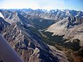
Upper course in the Elbow Pass
-
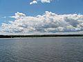
Glenmore Reservoir in Calgary
-
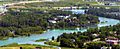
Confluence with Bow River


Images for kids
-
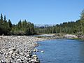
Elbow River at Redwood Meadows

See also
 In Spanish: Río Elbow para niños
