
Alberta Highway 22 facts for kids
Quick facts for kids
|
||||
|---|---|---|---|---|
| Cowboy Trail | ||||
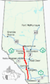
 Highway 22 highlighted in red
|
||||
| Route information | ||||
| Length | 574 km (357 mi) | |||
| Major junctions | ||||
| South end | ||||
|
||||
| North end | ||||
| Location | ||||
| Specialized and rural municipalities: |
Pincher Creek No. 9 M.D., Ranchland No. 26 M.D., Foothills County, Rocky View County, Mountain View County, Clearwater County, Wetaskiwin No. 10 County, Brazeau County, Parkland County, Yellowhead County, Lac Ste. Anne County | |||
| Towns: | Diamond Valley, Cochrane, Sundre, Rocky Mountain House, Drayton Valley, Mayerthorpe | |||
| Villages: | Longview, Cremona, Caroline | |||
| Highway system | ||||
Provincial highways in Alberta
|
||||

.svg)
Alberta Provincial Highway No. 22, also known as Highway 22 or the Cowboy Trail, is a long road in Alberta, Canada. It stretches for about 584 kilometers (363 miles). This highway runs mostly north and south, following the eastern side of the Rocky Mountains.
The Cowboy Trail starts in the southern foothills of Alberta near Lundbreck Falls. It goes through beautiful ranch country and ends near Mayerthorpe in northern Alberta. This highway is a scenic route that shows off Alberta's natural beauty.
The Cowboy Trail actually extends beyond Highway 22. It follows Highway 3 to Pincher Creek, Highway 6 to Waterton Lakes National Park, and Highway 5 to Cardston.
The government of Alberta is working on improving Highway 22. For example, they are building a new interchange where Highway 22 meets Highway 1A in Cochrane. An interchange helps traffic flow smoothly without stopping. There are also plans to make parts of the highway wider, adding more lanes for easier driving.
Contents
What is the Cowboy Trail?

Highway 22 is a very important road in central and southern Alberta. It is the longest north-south highway in this area, besides Highway 2. It helps connect many communities in the western part of the Calgary–Edmonton Corridor.
For a long time, Highway 22 didn't have much traffic. It was a two-lane road with only a few extra lanes for passing. This was because a faster, four-lane highway (Highway 2) was less than 100 kilometers (62 miles) to the east. However, since the mid-1990s, the area west of Calgary has grown a lot. This has made some parts of Highway 22, especially between Diamond Valley and Sundre, very busy.
Exploring Southern Alberta on Highway 22
Highway 22 begins as a two-lane road in southern Alberta. It starts near Lundbreck Falls at Highway 3. The highway travels north through the foothills, following the Oldman River. There are no big towns in this first part of the journey.
As you drive north, the highway passes near the Black Heritage Rangeland Natural Area. It crosses Highway 520, which goes east towards Claresholm. Highway 22 continues through beautiful scenery to the Chain Lakes Reservoir. From there, Highway 533 goes east towards Nanton.
Further north, the highway goes through several towns and villages. These include Longview, Diamond Valley (which used to be two towns, Black Diamond and Turner Valley), and Millarville. The highway then turns west at an intersection with Highway 22X.
About 30 kilometers (19 miles) later, the road turns north again at an intersection with Highway 66. It passes through a small part of Bragg Creek and then through a section of the Tsuu T'ina 145 Reservation, near Redwood Meadows. After leaving the reservation, Highway 22 reaches a Roundabout at Highway 8. It then enters Rocky View County and crosses the Elbow River. From there, it heads north past an interchange with the Trans-Canada Highway (Highway 1). Finally, it reaches the town of Cochrane, which is a large and growing community.
Driving Through Cochrane
Highway 22 is the main north-south road in Cochrane. It is one of only two roads that cross the Bow River in this area. The Bow River divides the town in half.
When you enter Cochrane, the two-lane highway goes through a major intersection at Fireside Gate/James Walker Trail. It then dips down into the Bow River Valley. There's an uphill passing lane for southbound traffic here. After another traffic light at George Fox Trail, the highway crosses the Bow River on a two-lane bridge.
On the other side of the river, you'll pass through three more traffic lights quickly. These are at Griffin Road, Quigley Drive, and Bow Valley Trail (Highway 1A). The intersection with Highway 1A is being replaced with an interchange to help traffic move better. The highway then goes up a hill (with a northbound passing lane) out of the river valley. It meets one last traffic light at Sunset Drive before leaving the town.
Central Alberta Journey
After leaving Cochrane, Highway 22 passes the small community of Cochrane Lake. It then reaches an important intersection with Highway 567. From there, it continues north to the village of Cremona. It then meets Highway 27 at another intersection.
After a short turn to the west, the highway reaches Sundre. Here, it turns north again towards Caroline. After another short turn west, the highway crosses the Red Deer River. It then heads north to Rocky Mountain House. In Rocky Mountain House, Highway 22 shares a short section of road with Highway 11.
From Rocky Mountain House, the highway continues north to Highway 39. Here, it turns west for the fourth time, crossing the North Saskatchewan River and reaching Drayton Valley. It keeps going north from Drayton Valley and meets Highway 16 (the Yellowhead Highway) at Entwistle. This is about 85 kilometers (53 miles) west of Edmonton.
After sharing the road with Highway 16 for about 8 kilometers (5 miles) going west, Highway 22 turns north again. It crosses Highway 43 in Mayerthorpe. The highway finally ends about 7 kilometers (4 miles) north of Mayerthorpe, at Highway 18.
How Highway 22 Changed Over Time
The original Highway 22 started south of Calgary and went west to Priddis. From there, it turned south to Turner Valley and ended at Highway 7 in Black Diamond.
In the 1970s, Alberta started to improve roads to create a major north-south highway west of Highway 2. Around 1972, the road between the Trans-Canada Highway and Cochrane became part of Highway 22. In 1973, a new system for secondary highways was introduced. The road between Cochrane and Highway 27 was called Highway 922.
Throughout the 1970s, Highway 922 was extended. It eventually stretched from Highway 3 in the south to Highway 57 near Drayton Valley in the north. As Highway 922 was paved around 1976, Highway 22 was extended from Cochrane to Cremona. The next year, Highway 22 took over the section between the Trans-Canada Highway and Priddis. The part between Priddis and Macleod Trail was renamed Highway 22X.
Around 1980, all the remaining unpaved sections of Highway 922 became part of Highway 22. This also included parts of other highways, like a section of Highway 7 between Black Diamond and Longview. By the mid-1990s, almost all of Highway 22 was paved.
In 2014, a new bridge was finished over the North Saskatchewan River near Drayton Valley. This $52 million bridge replaced an older one built in 1957.
In 2019, the interchange where Highway 22 crosses Highway 1 was updated to make it safer. Some ramps were removed, and a new traffic light was added on Highway 22.
Starting in 2022, a section of Highway 22 between Highway 1 and Highway 8 began to be changed. It is being moved and raised to avoid flooding from the new Springbank dry reservoir. This project also includes building a bridge for Highway 22 over a new canal that will feed the reservoir.
What's Next for Highway 22?
In April 2017, Alberta Transportation announced plans for a new interchange at Highway 1A in Cochrane. After some delays, construction finally started in May 2023. This interchange is expected to take three years to complete. When it's finished, it will allow traffic on Highway 22 to move through without stopping.
The 2024 Provincial Construction Program shows plans for new roundabouts on Highway 22 in Bragg Creek and at Highway 567. These are in the design phase, meaning they will likely be built soon. There are also plans to make Highway 22 wider within Cochrane, including a new bridge over the Bow River. This section will likely be the first part of Highway 22 to have four lanes.
Alberta Transportation also looked into adding new passing lanes on Highway 22 between Highways 3 and 543. A study in 2011 said these lanes would be helpful. Although there were no immediate plans then, these passing lanes are now being assessed for engineering. This means they will probably be built in the near future.
There are also plans to make Highway 22 wider, with two lanes in each direction, between Cochrane and Highway 8. In the long term, it might even be widened to six lanes. The interchange at Highway 1 will also be upgraded. No exact dates have been set for these projects yet.
See Also
- List of Alberta provincial highways
Images for kids
-
Highway 22 highlighted in red
-
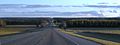
Southbound Highway 22, north of Sundre
