Rocky View County facts for kids
Quick facts for kids
Rocky View County
Municipal District of Rocky View No. 44 (1956–2009)
Municipal District of Calgary No. 44 (1955–1956) |
|||
|---|---|---|---|

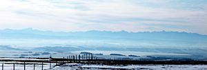
View of the Rockies and Foothills
|
|||
|
|||

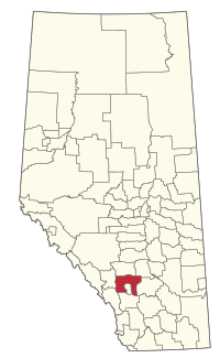
Location within Alberta
|
|||
| Country | Canada | ||
| Province | Alberta | ||
| Planning region | South Saskatchewan | ||
| Metropolitan area | Calgary | ||
| Incorporated | January 1, 1955 | ||
| Name changed | January 9, 1956 June 24, 2009 |
||
| Administrative office | Balzac | ||
| Area
(2021)
|
|||
| • Land | 3,828.85 km2 (1,478.33 sq mi) | ||
| Population
(2021)
|
|||
| • Total | 41,028 | ||
| • Density | 10.7/km2 (28/sq mi) | ||
| Time zone | UTC−7 (MST) | ||
| • Summer (DST) | UTC−6 (MDT) | ||
| Forward sortation area |
T1Z
|
||
Rocky View County is a special type of local government area called a municipal district in southern Alberta, Canada. It's named for the amazing views of the Rocky Mountains you can see to the west. This county almost completely surrounds the big city of Calgary, forming its northern, western, and eastern borders.
With over 41,000 people living there in 2021, Rocky View County is the most populated municipal district in Alberta. Even though it's mostly rural (meaning it has lots of open land and farms), it's also home to 14 hamlets, which are small communities. One of these, Langdon, is one of Alberta's largest hamlets. Many country homes and small neighborhoods are also found in its rural areas.
Contents
History of Rocky View County
The area now known as Rocky View County started as the Municipal District (MD) of Calgary No. 44. This happened on January 1, 1955. It was created from parts of several other districts.
How Rocky View County Got Its Name
The name "Rocky View" was chosen in December 1955 after a local competition. Leslie Burwash from Balzac suggested the winning name. Other ideas included "Bow View" and "Chinook".
The name "Rocky View" was picked because it perfectly describes the area. Most places within the county offer beautiful views of the Rocky Mountains to the west. On January 9, 1956, the MD of Calgary No. 44 officially changed its name to the MD of Rocky View No. 44. Later, on June 24, 2009, its name was shortened to Rocky View County.
Geography and Communities
Rocky View County is surrounded by several towns and cities. It also contains many smaller communities within its borders.
Neighboring Urban Areas
|
These urban municipalities are located next to Rocky View County:
|
Hamlets in Rocky View County
The following hamlets are located inside Rocky View County:
- Hamlets
- Balzac
- Bottrel
- Bragg Creek
- Cochrane Lake
- Conrich
- Dalemead
- Dalroy
- Delacour
- Indus
- Janet
- Kathyrn
- Keoma
- Langdon
- Madden
Other Localities and Areas
Many other smaller places, called localities, are also found within Rocky View County. These include:
- Localities
- Allandale Estates
- Anatapy
- Artists View East Subdivision
- Artists View Park West
- Banded Peak Place
- Bearspan Heights
- Bearspaw
- Bennett
- Braemore Ranch
- Caldbeck
- Calling Horse Estates
- Camp Gardner
- Circle Five
- Colpitts Ranch Subdivision
- Country Estates
- Craigdhu
- Croxford Estates
- Cullen Creek
- Deerwood Estates
- Del-Rich Meadows
- Elbow River Estates
- Elk Valley Park
- Entheos West
- Fawnhill
- Garden Heights
- Georgian Estates
- Ghost Dam
- Glenbow
- Green Valley Place
- Helmsdale
- High Point Estates
- Idlewood Estates
- Inverlake
- Kersey
- Lake Erie Estates
- Lansdowne Estates
- Livingstone Estates
- Mitford
- Mount View Estates
- Mountain View Estates
- Murray Acres Estates
- Nier
- Norfolk
- O'Neil Ranchettes
- Partridge Place
- Pinebrook Estates
- Pirmez Creek
- Prairie Royale
- Radnor
- River Ridge Estates
- Robertson
- Rocky View
- Rolling Range Estates
- Rosewood
- Springbank Meadows
- Springgate Estates
- Springland Estates
- Springshire Estates
- Toki Estates
- Tower Ridge Estates
- West Bluff Road Subdivision
- Wild Rose Country Estates
- Wildcat
- Williams Subdivision
- Wintergreen
- Other places
- Bearspaw-Glendale (country residential area)
- Elbow Valley (country residential area)
- Harmony (urban community)
- Heritage Woods
- Springbank (country residential area)
Population and Demographics
Rocky View County has been growing steadily. A census is like a big count of all the people living in an area.
In the 2021 Census, Rocky View County had a population of 41,028 people. This was a good increase from its population of 39,407 in 2016. The county covers a land area of about 3,829 square kilometers (1,478 square miles). This means there are about 10.7 people living in each square kilometer.
Fun Places to Visit
Rocky View County has many cool places to explore:
- Big Hill Springs Provincial Park
- Bragg Creek Community Centre and historic downtown
- Bragg Creek Provincial Park
- Calaway Park (a popular amusement park!)
- Century Downs Racetrack and Casino
- CrossIron Mills (a large shopping mall)
- Glenbow Ranch Provincial Park
- Pioneer Acres Museum
How to Get Around: Transportation
Rocky View County has important roads, railways, and airports that help people and goods move around.
Major Highways
Two very important highways, the Trans-Canada Highway (Highway 1) and Highway 2, pass right through Rocky View County. Highway 9 is another key road in the eastern part of the county, connecting Calgary to Saskatoon, Saskatchewan.
 Hwy 1 (TCH)
 Hwy 1A
 Hwy 2
Hwy 2 Hwy 2A
 Hwy 8
Hwy 8
|
|
|
Railways
Major train lines from two big railway companies, Canadian Pacific Kansas City (CPKC) and Canadian National Railway (CNR), run through Rocky View County. These lines connect Calgary and Edmonton. The CPKC line goes through Airdrie and Crossfield, while the CNR line passes through Irricana and Beiseker.
Airports
Rocky View County is also home to two airports: Beiseker Airport and Springbank Airport.
 | Madam C. J. Walker |
 | Janet Emerson Bashen |
 | Annie Turnbo Malone |
 | Maggie L. Walker |


