County of Wetaskiwin No. 10 facts for kids
Quick facts for kids
County of Wetaskiwin No. 10
|
|
|---|---|

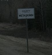
County line sign
|
|

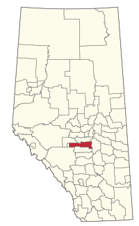
Location within Alberta
|
|
| Country | Canada |
| Province | Alberta |
| Region | Central Alberta |
| Census division | 11 |
| Established | 1943 |
| Incorporated | 1958 (County) |
| Area
(2021)
|
|
| • Land | 3,121.98 km2 (1,205.40 sq mi) |
| Population
(2021)
|
|
| • Total | 11,212 |
| • Density | 3.6/km2 (9/sq mi) |
| Time zone | UTC−7 (MST) |
| • Summer (DST) | UTC−6 (MDT) |
The County of Wetaskiwin No. 10 is a municipal district in central Alberta, Canada that is south of Edmonton. Located in Census Division No. 11, its municipal office is in located in the City of Wetaskiwin.
Geography
Communities and localities
|
The following urban municipalities are surrounded by the County of Wetaskiwin No. 10.
|
The following hamlets are located within the County of Wetaskiwin No. 10.
|
The following localities are located within the County of Wetaskiwin No. 10.
- Localities
|
|
Demographics
In the 2021 census conducted by Statistics Canada, the County of Wetaskiwin No. 10 had a population of 11,212 living in 4,490 of its 5,675 total private dwellings, a change of 0.3% from its 2016 population of 11,176. With a land area of 3,121.98 km2 (1,205.40 sq mi), it had a population density of 3.6/km2 (9.3/sq mi).
In the 2016 census conducted by Statistics Canada, the County of Wetaskiwin No. 10 had a population of 11,181 living in 4,372 of its 5,556 total private dwellings, a 2.9% change from its 2011 population of 10,866. With a land area of 3,132.06 km2 (1,209.30 sq mi), it had a population density of 3.6/km2 (9.3/sq mi).

