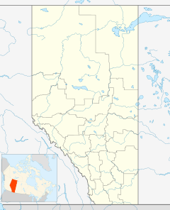
Winfield, Alberta facts for kids
Quick facts for kids
Winfield
|
|
|---|---|
|
Hamlet
|
|
| Country | Canada |
| Province | Alberta |
| Region | Central Alberta |
| Census division | 11 |
| Municipal district | County of Wetaskiwin No. 10 |
| Government | |
| • Type | Unincorporated |
| Area
(2021)
|
|
| • Land | 1.07 km2 (0.41 sq mi) |
| Elevation | 926 m (3,038 ft) |
| Population
(2021)
|
|
| • Total | 193 |
| • Density | 180.5/km2 (467/sq mi) |
| Time zone | UTC-7 (MST) |
| • Summer (DST) | UTC-6 (MDT) |
| Postal code span |
T0C
|
| Area code(s) | +1-780, +1-587 |
| Highways | Alberta Highway 13 |
| Highway | Alberta Highway 20 |
| Website | Wetaskiwin County |
Winfield is a small community called a hamlet in Alberta, Canada. It is part of the County of Wetaskiwin No. 10. You can find Winfield where two main roads, Highway 13 and Highway 20, meet. It is about 70 kilometers (43 miles) west of the city of Wetaskiwin.
Contents
Understanding Winfield's Climate
Winfield has a type of weather called a subarctic climate. This means it has very cold winters and mild summers. It is also close to a humid continental climate, which has warm summers and cold winters.
Temperatures in Winfield
The average temperature in January, which is the coldest month, is about -9.1°C (15.6°F). In July, the warmest month, the average temperature is around 15.5°C (59.9°F). However, Winfield has seen some extreme temperatures. It has been as cold as -44.5°C (-48.1°F) and as hot as 34.0°C (93.2°F)!
Precipitation and Seasons
Winters in Winfield are usually cold and dry. Snow covers the ground from mid-November until early April. Summers are warm with long daylight hours. Most of the rain falls during the summer months, often from thunderstorms. July gets the most rain, with an average of 131.1 millimeters (5.16 inches).
| Climate data for Winfield, Alberta | |||||||||||||
|---|---|---|---|---|---|---|---|---|---|---|---|---|---|
| Month | Jan | Feb | Mar | Apr | May | Jun | Jul | Aug | Sep | Oct | Nov | Dec | Year |
| Record high °C (°F) | 17.0 (62.6) |
17.0 (62.6) |
23.5 (74.3) |
28.5 (83.3) |
31.0 (87.8) |
33.0 (91.4) |
34.0 (93.2) |
32.5 (90.5) |
32.5 (90.5) |
28.5 (83.3) |
20.0 (68.0) |
17.5 (63.5) |
34.0 (93.2) |
| Mean daily maximum °C (°F) | −3.5 (25.7) |
−0.6 (30.9) |
2.9 (37.2) |
10.5 (50.9) |
16.0 (60.8) |
19.2 (66.6) |
21.7 (71.1) |
21.2 (70.2) |
16.1 (61.0) |
10.3 (50.5) |
1.5 (34.7) |
−2.5 (27.5) |
9.4 (48.9) |
| Daily mean °C (°F) | −9.1 (15.6) |
−6.5 (20.3) |
−2.8 (27.0) |
4.2 (39.6) |
9.3 (48.7) |
13.1 (55.6) |
15.5 (59.9) |
14.6 (58.3) |
9.8 (49.6) |
4.4 (39.9) |
−3.6 (25.5) |
−7.7 (18.1) |
3.4 (38.1) |
| Mean daily minimum °C (°F) | −14.6 (5.7) |
−12.3 (9.9) |
−8.4 (16.9) |
−2.1 (28.2) |
2.7 (36.9) |
6.8 (44.2) |
9.1 (48.4) |
8.0 (46.4) |
3.4 (38.1) |
−1.6 (29.1) |
−8.6 (16.5) |
−13 (9) |
−2.5 (27.5) |
| Record low °C (°F) | −43.0 (−45.4) |
−40 (−40) |
−39 (−38) |
−26.0 (−14.8) |
−13.0 (8.6) |
−2.8 (27.0) |
0.0 (32.0) |
−4.0 (24.8) |
−7.5 (18.5) |
−26.5 (−15.7) |
−37.0 (−34.6) |
−44.5 (−48.1) |
−44.5 (−48.1) |
| Average precipitation mm (inches) | 22.8 (0.90) |
17.2 (0.68) |
23.0 (0.91) |
27.4 (1.08) |
65.1 (2.56) |
102.5 (4.04) |
131.1 (5.16) |
85.5 (3.37) |
62.3 (2.45) |
28.8 (1.13) |
19.6 (0.77) |
17.0 (0.67) |
602.3 (23.71) |
| Average rainfall mm (inches) | 1.2 (0.05) |
0.1 (0.00) |
1.4 (0.06) |
17.4 (0.69) |
57.6 (2.27) |
102.5 (4.04) |
131.1 (5.16) |
85.5 (3.37) |
60.4 (2.38) |
19.0 (0.75) |
2.0 (0.08) |
0.4 (0.02) |
478.6 (18.84) |
| Average snowfall cm (inches) | 22.1 (8.7) |
17.1 (6.7) |
21.6 (8.5) |
10.1 (4.0) |
7.4 (2.9) |
0.0 (0.0) |
0.0 (0.0) |
0.0 (0.0) |
1.9 (0.7) |
9.8 (3.9) |
17.7 (7.0) |
16.6 (6.5) |
124.2 (48.9) |
| Source: Environment Canada | |||||||||||||
Winfield's Population
Every few years, Statistics Canada counts how many people live in different places. This count is called a census.
Population in 2021
In the 2021 Census, Winfield had a population of 193 people. These people lived in 85 homes out of 96 available homes. This number was a decrease of about 18.9% from its population in 2016. Winfield covers a land area of 1.07 square kilometers (0.41 square miles). This means there were about 180.5 people living in each square kilometer in 2021.
Population in 2016
In the 2016 Census, Winfield had 238 people. They lived in 85 homes out of 98 available homes. This was a small increase of about 6.3% from its population in 2011, which was 224 people. In 2016, the population density was about 222.4 people per square kilometer.
 | Audre Lorde |
 | John Berry Meachum |
 | Ferdinand Lee Barnett |


