Wetaskiwin facts for kids
Quick facts for kids
Wetaskiwin
|
|||||
|---|---|---|---|---|---|
|
City
|
|||||
| City of Wetaskiwin | |||||
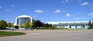
Reynolds-Alberta Museum in Wetaskiwin
|
|||||
|
|||||
| Motto(s):
"Pacem Volo Bellum Paro"
|
|||||
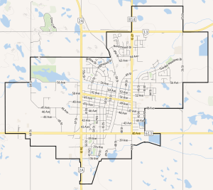
City boundaries
|
|||||
| Country | Canada | ||||
| Province | Alberta | ||||
| Planning region | North Saskatchewan | ||||
| Municipal district | County of Wetaskiwin No. 10 | ||||
| Founded | 1892 | ||||
| Incorporated | |||||
| • Village | December 4, 1899 | ||||
| • Town | April 5, 1902 | ||||
| • City | May 9, 1906 | ||||
| Area
(2021)
|
|||||
| • Land | 18.75 km2 (7.24 sq mi) | ||||
| Elevation | 760 m (2,490 ft) | ||||
| Population
(2021)
|
|||||
| • Total | 12,594 | ||||
| • Density | 671.6/km2 (1,739/sq mi) | ||||
| • Municipal census (2014) | 12,621 | ||||
| • Estimate (2020) | 12,996 | ||||
| Time zone | UTC−7 (MST) | ||||
| • Summer (DST) | UTC−6 (MDT) | ||||
| Forward sortation area |
T9A
|
||||
| Area code(s) | 780, 587, 825, 368 | ||||
| Highways |
|
||||
Wetaskiwin (/wəˈtæsk(ə)wɪn/ WƏ-tas-K(Ə-)win) is a city in Alberta, Canada. It's about 70 kilometers (43 miles) south of Edmonton, the provincial capital. The name "Wetaskiwin" comes from the Cree word wītaskiwinihk, which means "the hills where peace was made."
The city is home to the Reynolds-Alberta Museum, which celebrates machines and technology. You can also visit the Wetaskiwin and District Heritage Museum to learn about the early settlers. Southeast of the city, the Alberta Central Railway Museum shows how important railways were to Central Alberta.
Wetaskiwin is famous in Western Canada for its catchy slogan, "Cars cost less in Wetaskiwin." This jingle has been used in ads since the mid-1970s.
Contents
History of Wetaskiwin
The area where Wetaskiwin now stands was once a battlefield. The Cree and Blackfoot First Nations fought here. They later made peace, calling the spot Wee-Tas-Ki-Win-Spatinow, meaning "the place where peace was made."
In 1890, the Calgary and Edmonton Railway built a stop here, known as Siding 16. In 1892, the area was surveyed and officially named Wetaskiwin. Soon after, Scandinavian immigrants settled in the new town. Businesses opened, and a newspaper called the Free Lance started.
A Baptist church was built in 1900. By 1901, the village had over 500 people and became officially incorporated. By 1908, Wetaskiwin had a town hall and several churches. The city's courthouse was built in 1909, and the water tower around the same time. After World War II, the Wetaskiwin airport was built. This airport later became the site of the Reynolds-Alberta Museum.
Geography and Climate
Wetaskiwin is located on land that was once part of a huge ancient sea. The northwest part of the city has sandy hills, which used to be sand dunes. The southeast part is very flat with silty soil.
The city is about 760 meters (2,493 feet) above sea level. Coal Lake, a reservoir on the Battle River, is just east of the city. Other nearby waterways include Pipestone Creek, Bigstone Creek, Bittern Lake, and Bearhills Lake.
Wetaskiwin is an important meeting point for Highway 2A, Highway 13, and the Canadian Pacific Kansas City railway. It was once a stagecoach stop between Calgary and Edmonton.
Wetaskiwin's Climate
Wetaskiwin has a humid continental climate. This means it has warm summers with cool nights and cold winters. It's a good place for many plants, falling into Plant hardiness zone 3b.
| Climate data for Wetaskiwin | |||||||||||||
|---|---|---|---|---|---|---|---|---|---|---|---|---|---|
| Month | Jan | Feb | Mar | Apr | May | Jun | Jul | Aug | Sep | Oct | Nov | Dec | Year |
| Record high °C (°F) | 11.5 (52.7) |
15 (59) |
25.0 (77.0) |
28.5 (83.3) |
34.0 (93.2) |
34.5 (94.1) |
36.0 (96.8) |
35.5 (95.9) |
32.5 (90.5) |
29.5 (85.1) |
18.5 (65.3) |
16.0 (60.8) |
36.0 (96.8) |
| Mean daily maximum °C (°F) | −5.2 (22.6) |
−2.2 (28.0) |
2.6 (36.7) |
11.8 (53.2) |
17.8 (64.0) |
21.4 (70.5) |
24.0 (75.2) |
22.8 (73.0) |
18.1 (64.6) |
11.1 (52.0) |
0.7 (33.3) |
−2.7 (27.1) |
10.0 (50.0) |
| Daily mean °C (°F) | −10.5 (13.1) |
−7.9 (17.8) |
−2.9 (26.8) |
5.4 (41.7) |
11.0 (51.8) |
15.2 (59.4) |
17.6 (63.7) |
16.2 (61.2) |
11.5 (52.7) |
5.0 (41.0) |
−4.2 (24.4) |
−7.9 (17.8) |
4.1 (39.4) |
| Mean daily minimum °C (°F) | −15.7 (3.7) |
−13.6 (7.5) |
−8.3 (17.1) |
−1.1 (30.0) |
4.2 (39.6) |
9.0 (48.2) |
11.2 (52.2) |
9.6 (49.3) |
4.7 (40.5) |
−1.2 (29.8) |
−9 (16) |
−13.1 (8.4) |
−2 (28) |
| Record low °C (°F) | −40 (−40) |
−39.5 (−39.1) |
−34 (−29) |
−19.5 (−3.1) |
−9.5 (14.9) |
0.5 (32.9) |
3.0 (37.4) |
−2.5 (27.5) |
−7 (19) |
−22.5 (−8.5) |
−33 (−27) |
−37.5 (−35.5) |
−40 (−40) |
| Average precipitation mm (inches) | 27.9 (1.10) |
18.4 (0.72) |
26.7 (1.05) |
30.7 (1.21) |
51.2 (2.02) |
79.4 (3.13) |
92.3 (3.63) |
60.7 (2.39) |
41.7 (1.64) |
24.8 (0.98) |
25.0 (0.98) |
18.7 (0.74) |
497.2 (19.57) |
| Average rainfall mm (inches) | 1.7 (0.07) |
0.4 (0.02) |
2.9 (0.11) |
18.3 (0.72) |
46.3 (1.82) |
79.4 (3.13) |
92.3 (3.63) |
60.7 (2.39) |
40.9 (1.61) |
14.2 (0.56) |
2.3 (0.09) |
1.2 (0.05) |
360.5 (14.19) |
| Average snowfall cm (inches) | 26.2 (10.3) |
18.0 (7.1) |
23.7 (9.3) |
12.4 (4.9) |
4.9 (1.9) |
0 (0) |
0 (0) |
0 (0) |
0.8 (0.3) |
10.6 (4.2) |
22.8 (9.0) |
17.5 (6.9) |
136.8 (53.9) |
| Source: Environment Canada | |||||||||||||
Population and People
|
||||||||||||||||||||||||||||||||||||||||||||||||||||||||||||||||||||||||||||||||||||
In 2021, Wetaskiwin had a population of 12,594 people. This was a small decrease from its 2016 population of 12,655. The city covers an area of about 18.75 square kilometers (7.24 square miles).
In 2006, almost 12% of the people in Wetaskiwin identified as aboriginal. Most residents (about 90%) speak English as their first language. Other languages spoken include German, French, Cree, and Tagalog.
About 75% of residents identified as Christian in 2001. Many others said they had no religious affiliation.
Cool Places to Visit
Wetaskiwin's Water Tower
Built in 1909, Wetaskiwin's water tower is one of Canada's oldest. This tall structure is 42 meters (138 feet) high and holds over 450,000 liters (120,000 gallons) of water.
In 2004, there was talk of tearing it down. But people in the city wanted to save it. So, in 2005, work began to fix it up. By 2006, the water tower was fully restored.
Peace Cairn Monument
The Wetaskiwin Peace Cairn remembers 60 years of peace. This peace was made between the Blackfoot and Cree First Nations. It happened in some hills just north of where Wetaskiwin is today.
When the cairn was built, school children helped. They each carried a rock in a parade from their school to the hill. The cairn was officially opened on July 2, 1927. This was part of Canada's Diamond Jubilee celebrations.
Manluk Centre for Fun
The Manluk Centre is a large building, about 44,756 square feet. It opened on September 13, 2014. The second floor has the Flaman Fitness Facility. Local businesses and people helped pay for the center.
It has a 25-meter pool, a fun leisure pool, and a lazy river. There's also a wave machine, slides, a whirlpool, and a steam room.
City Hall Building
The building that is now City Hall was first built as a courthouse. It was finished in 1908 and cost $75,000. It was one of seven courthouses built in Alberta between 1906 and 1912.
The building is made of red brick in a modern renaissance style. The steps, columns, and foundation are made of stone. In the early days, the basement had jail cells and living areas for the caretaker and police. You can still see carvings prisoners made on the brick walls!
In 1983, a new courthouse was built. The old one was empty for over 20 years. In the late 1990s, a developer suggested making it the new City Hall. The city bought the building, and renovations started in 2005. The outside brick was kept, and the original courtroom was restored. It now serves as the Council Chambers. In 2007, the building became Wetaskiwin's new City Hall.
By-the-Lake Park
Wetaskiwin's By-the-Lake Park is a great place to spend the day. It's near the downtown area. The park has a 2.5-kilometer (1.5-mile) paved path around a 17-acre man-made lake. There's also a large picnic area.
A nature trail has signs that tell you about the plants and animals. The lake is stocked with fish for summer and winter fishing. Schools and groups use the lake for canoeing and other water sports. In winter, people enjoy cross-country skiing, ice skating, tobogganing, and pond hockey here.
City Services and Media
The Wetaskiwin Regional Airport is located within the city.
Wetaskiwin has two local newspapers: the Pipestone Flyer and The Wetaskiwin Times. There is also a radio station, CKJR, which broadcasts sports radio from Edmonton.
Education in Wetaskiwin
Wetaskiwin Regional Public Schools manages the public schools in the area. This includes Wetaskiwin Composite High School. St. Thomas Aquinas Roman Catholic Schools runs Sacred Heart School (for grades K-9) in Wetaskiwin.
Famous People from Wetaskiwin
- Rod Buskas, a former professional hockey player
- Jackson Davies, an actor
- Val Fonteyne, a former professional hockey player
- Paul Greene, an actor
- Gus Marker, a former professional hockey player
- Lori Radke, a former Paralympic wheelchair basketball player
- Stan Reynolds, a generous supporter of good causes
- Harnarayan Singh, a hockey announcer
- Martin Sonnenberg, a professional hockey player
- Aritha van Herk, an author and academic
- Allen York, a professional hockey player
- Justine Bouchard, a gold medalist wrestler
See also
 In Spanish: Wetaskiwin para niños
 | Percy Lavon Julian |
 | Katherine Johnson |
 | George Washington Carver |
 | Annie Easley |


